Tag Archives: Google Maps

A new homescreen on Google Maps – designed for users in India

Earlier this week, we have rolled out a new home screen on Google Maps for Android, specifically designed for people in India. The new home screen makes Google Maps easier to use, letting you navigate around and explore things with just one tap. The newly added visual elements let you spend less time searching for your destination and more time enjoying your journey. And with this update, the new home screen will load the map much faster - so the millions of people in India coming online can discover and share great places, even on spotty connections.

2017-04-26 15_56_05.gif

Maps are great for helping you get from A to B, for instance when you’re looking for directions before hopping on a scooter to Connaught Place in New Delhi. Now when you fire up your Google Maps app, you’ll instantly see a directions panel with icons for modes of transportations. So whether you’d like to take the bus or are planning to go by foot to a new mall that just opened near you, just type in the place you’d like to go to and you’ll get directions in just one tap. While you’re looking for directions, the map can load in the background, making the home screen load much faster on slow connections. And if you’d like to access a certain route while you’re on the go without using data, you can also save a route to be used offline.

Below the directions panel, you’ll also see icons highlighting some of the other useful features on Maps. From getting a first impression of a place with satellite imagery to real-time information about traffic around you, to more details about transit lines when you’re on the road - these features are now just a tap away. In addition, with a tap on the download icon, you can now download a specific map area for offline use, so you can explore your surroundings even when you’re in a place with spotty connectivity or no connectivity at all.

This new home screen is designed for people in India - we’re hoping that this helps to provide a much more intuitive and faster experience for users in India. We’ll continue to evolve our Maps and Local products to make them useful no matter where you go or what you do in India, especially for the millions of people coming online for the first time.

Posted by Cathay Bi, Product Manager, Google Maps

Vimy through the lens of Google Maps

Ed. Note: Today’s blog post is authored by Peter Mansbridge, the Chief Correspondent for CBC News. It’s also cross-posted to CBCNews.ca.

So here's a challenge: How do you engage a new generation with an old story about a military battle thousands of kilometers away? That's what we had to consider when we decided to re-tell the story of Vimy Ridge.
Vimy is one of those names that Canadians mention when they talk about their country's military past – names like The Plains of Abraham, Ypres, Dieppe, Normandy and many, many others. But what do they really know about what happened a century ago now on that towering ridge in northern France? Did we win, did we lose, did it really make a difference? And perhaps most important of all, why do some historians say it was in that bloody, horrific battle that Canada forged its soul and became a nation? All good questions, but how in today's world of short attention spans and handheld technology can we find new and captivating ways to answer them.
 That's why a seemingly odd pairing - a new age tech giant: Google Canada, teamed up with the supposedly staid old Mother Corp (and it's aging anchor!) and headed off to the battlefield just last month. And within hours of arrival there I found myself with a Google "Trekker" strapped to my back, walking through the restored trenches of Vimy Ridge.

Trekker in the Trenches
The "Trekker" is the same piece of technology that takes those Street View pictures of downtowns across Canada It isn’t that heavy – it weighs about twenty kilograms – but it does make you a bit top heavy and you have to be careful not to topple over! But the benefits for the viewer are terrific – the "Trekker" puts you right there, walking through history along the same paths our grandfathers and great grandfathers did exactly one hundred years ago during the Easter weekend of 1917. That's when the 100,000 soldiers of Canada's four divisions, for the first time together, launched an attack on what was seen as the most strategic ridge the Germans held in France.
The Tunnels
Beneath the trenches, the tunnels that shuttled the troops to the front lines. Today they too are restored and safe – a far cry from the muddy, rat infested and highly dangerous subways that our forefathers used to get to the fight. And here again, we bring you right there. This time using The Odyssey - 16 interconnected GOPRO cameras - created a 360 degree video of your surroundings, to give you the ultimate feel. When watching through virtual reality goggles you can point the picture where you want to go, see what you want to see. The tunnels were an engineering feat - able to keep the soldiers and the officers safe, but right at the frontlines of the battle as it raged above.

Cemetery Trekker

Canada won the battle, and at home, that became a source of considerable national pride. And for the soldiers who did the fighting, a source of considerable and justified boasting. They had done what neither the French nor the British had been able to do over months of intense fighting. But Canada paid a very heavy price. Over four days of sometimes hand to hand combat, we lost nearly four thousand soldiers, and more than seven thousand wounded. In the Canadian Vimy cemetery thousands lie side by side – they're young, sometimes very young, ages paying testament to the generation we lost.
Monument at Vimy 
The Vimy monument sits high atop the ridge that so much Canadian blood was lost to win. It is tribute to all those who died in the Great War but whose bodies were never found --- all their names, more than 11 thousand of them – are carved into the monument's walls.

Every name a compelling story of a Canadian who had travelled across the oceans to fight for "King and Country". They were fathers, sons, brothers, cousins, farmers, teachers, lawyers, labourers, hockey players, artists, preachers …. and there were kids, school students who lied about their age to do what they thought was right.

In the classroom
In the past few days the results of the Google-YouTube-CBC partnership have started to hit some select Canadian schools. Last week a grade eight class in Harriston, Ontario watched in amazement. It can be disconcerting – you really DO feel like you're there, almost reaching out to touch the trenches, the tunnels, the carved names.

And really, that's what we were hoping would happen.

Letting that new generation to virtually reach back a century and touch a moment that helped make all us, and our country, who we are.

Share your trips and real-time location from Google Maps

“Where are you now?” and “What's your ETA?” Whether you’re heading to a party or meeting up for dinner, you probably hear questions like this pretty often from family and friends. Soon Google Maps users worldwide will be able to answer those questions in just a few taps, without ever leaving the app. On both Android and iOS, you’ll be able to share your real-time location with anyone. And the people you share with will be able to see your location on Android, iPhone, mobile web, and even desktop. Here’s how it works in a real-world scenario:

Whenever you want to let someone know where you are, just open the side menu or tap the blue dot that represents where you are. Tap “Share location” and then select who to share with and how long to share—and you're done! You can share your real-time location with your Google contacts, or even share with friends and family by sending a link on your favorite messenger apps. When you’re sharing your location, the people you’ve chosen to share with will see you on their map. And you’ll see an icon above the compass on your own map reminding you that you’re actively sharing your location. You can change your mind and stop sharing at any time—it’s entirely up to you.
    
Next time you’re on your way or running late, you can share your real-time location and trip progress from navigation as well. During your next trip, tap the “More” button on the bottom on the navigation screen, and then tap “Share trip.” When you share your trip with people, they’ll see your expected arrival time and can follow your journey as you head towards your destination. Sharing automatically ends when you arrive.
  

Location sharing on Google Maps is rolling out worldwide over the coming week, and you’ll be able to quickly let your friends and family know where you are and when you’ll get where you’re going. The answer to “where are you?” is only a tap away.

Posted by Sanket Gupta, Program Manager, Google Maps


Now it gets easier to plan your commute with the Google Maps transit feature in seven more Indian cities

~ Transit feature is now available in sixteen Indian cities ~


Want to reach somewhere and wondering which bus to take or which bus routes go to your destination? To help you better plan your commute around the city, and make it easier for you to get an overview of public transportation around you, we are expanding the transit feature on Google Maps to seven more Indian cities including Chandigarh, Lucknow, Vadodara, Indore, Mysore, Surat and Coimbatore.


With today’s update, the transit feature is now available in sixteen Indian cities – the seven newly added cities as well as Delhi, Mumbai, Bangalore, Chennai, Kolkata, Jaipur, Hyderabad, Pune, Ahmedabad.


Google Transit is a feature on Google Maps designed to help you plan your commute with only a couple of taps. For instance, if you’re going to Sukhna Lake in Chandigarh, just search for Sukhna Lake and Google Maps will show you how to get there from your current location. We’ll now show you bus routes and stops, including details such as departure and arrival times, the names of bus stands, and even where to change buses. You can scroll through the options and tap on the one that is most convenient for you, making it easier for you to know when to leave to arrive on time. Google Transit is available on Google Maps for Android and iOS as well as through your browser.


To try out the feature, just follow these steps:
  • Open Google Maps for Mobile on your Android or iOS device
  • Enter your destination and click the "get directions" icon. If it’s not already selected, tap the "transit" icon (the little tram) to view times, bus numbers, routes and more.


Google Maps is your guide to the world around you, and this launch is part of our effort to reflect the real world and provide you with relevant information about your surroundings. Google Maps globally provides over 1 billion km worth of transit results every day and has schedules for more than 2.5 million public transit stops worldwide. Google Transit is now available for hundreds of cities across dozens of countries, with new partners joining all the time.


Posted by Sanket Gupta, Product Manager, Google Maps

Keep track of your favorite places and share them with friends


Is your bucket list etched in your memory, or scribbled on a dozen post-it notes scattered around your home? Have you ever promised out-of-town guests an email full of your favorite spots, only to never get around to clicking send? Starting today, you can create lists of places, share your lists with others, and follow the lists your friends and family share with you—without ever leaving the Google Maps app (Android, iOS).

Getting started is easy. Simply open the Google Maps app and find that ‘Chaat’ spot you’ve been wanting to try. Tapping on the place name and then the “Save” icon adds the place to one of several pre-set lists like “Want to Go” or “Favorites.” You can also add the restaurant to a new list that you name yourself, like “Mouth Watering Chaat.” To recall the lists you’ve created, go to Your Places (in the side menu) and then open the saved tab. Icons for the places you’ve saved to lists will appear on the map itself, so you’ll always know whether one of your must-try Chaat spots is nearby.


Because sharing is caring, we made it easy to share lists like “Best Views in Mumbai or Best restaurants in Bangalore or ten must street food places in Delhi” via text, email, social networks and popular messaging apps. Whenever friends and family come to town, tap the share button to get a link and start flexing your local knowledge muscles. Once you send a link to your out-of-towners, they can tap “Follow” to pull up the list from Your Places whenever they need it. Here’s how it all works in real life:


The lists you follow are with you wherever you take Google Maps and are viewable on mobile and desktop—and even offline. Next time you're on a trip, download offline maps of the area in advance and you'll be able to see all the places you’ve added to lists on the map itself.

With the millions of landmarks, businesses and other points of interest in Google Maps, there’s no shortage of places to try. Now that we’ve got the world mapped, it’s your turn to map your world with Lists—from local hotspots to bucket list destinations worlds away.

Posted by Sanket Gupta, Program Manager, Google Maps

Using Machine Learning to predict parking difficulty


"When Solomon said there was a time and a place for everything he had not encountered the problem of parking his automobile." -Bob Edwards, Broadcast Journalist

Much of driving is spent either stuck in traffic or looking for parking. With products like Google Maps and Waze, it is our long-standing goal to help people navigate the roads easily and efficiently. But until now, there wasn’t a tool to address the all-too-common parking woes.

Last week, we launched a new feature for Google Maps for Android across 25 US cities that offers predictions about parking difficulty close to your destination so you can plan accordingly. Providing this feature required addressing some significant challenges:
  • Parking availability is highly variable, based on factors like the time, day of week, weather, special events, holidays, and so on. Compounding the problem, there is almost no real time information about free parking spots.
  • Even in areas with internet-connected parking meters providing information on availability, this data doesn’t account for those who park illegally, park with a permit, or depart early from still-paid meters.
  • Roads form a mostly-planar graph, but parking structures may be more complex, with traffic flows across many levels, possibly with different layouts.
  • Both the supply and the demand for parking are in constant flux, so even the best system is at risk of being outdated as soon as it’s built.
To face these challenges, we used a unique combination of crowdsourcing and machine learning (ML) to build a system that can provide you with parking difficulty information for your destination, and even help you decide what mode of travel to take — in a pre-launch experiment, we saw a significant increase in clicks on the transit travel mode button, indicating that users with additional knowledge of parking difficulty were more likely to consider public transit rather than driving.

Three technical pieces were required to build the algorithms behind the parking difficulty feature: good ground truth data from crowdsourcing, an appropriate ML model and a robust set of features to train the model on.

Ground Truth Data
Gathering high-quality ground truth data is often a key challenge in building any ML solution. We began by asking individuals at a diverse set of locations and times if they found the parking difficult. But we learned that answers to subjective questions like this produces inconsistent results - for a given location and time, one person may answer that it was “easy” to find parking while another found it “difficult.” Switching to objective questions like “How long did it it take to find parking?” led to an increase in answer confidence, enabling us to crowdsource a high-quality set of ground truth data with over 100K responses.

Model Features
With this data available, we began to determine features we could train a model on. Fortunately, we were able to turn to the wisdom of the crowd, and utilize anonymous aggregated information from users who opt to share their location data, which already is a vital source of information for estimates of live traffic or popular times and visit durations.

We quickly discovered that even with this data, some unique challenges remain. For example, our system shouldn’t be fooled into thinking parking is plentiful if someone is parking in a gated or private lot. Users arriving by taxi might look like a sign of abundant parking at the front door, and similarly, public-transit users might seem to park at bus stops. These false positives, and many others, all have the potential to mislead an ML system.

So we needed more robust aggregate features. Perhaps not surprisingly, the inspiration for one of these features came from our own backyard in downtown Mountain View. If Google navigation observes many users circling downtown Mountain View during lunchtime along trajectories like this one, it strongly suggests that parking might be difficult:
Our team thought about how to recognize this “fingerprint” of difficult parking as a feature to train on. In this case, we aggregate the difference between when a user should have arrived at a destination if they simply drove to the front door, versus when they actually arrived, taking into account circling, parking, and walking. If many users show a large gap between these two times, we expect this to be a useful signal that parking is difficult.

From there, we continued to develop more features that took into account, for any particular destination, dispersion of parking locations, time-of-day and date dependence of parking (e.g. what if users park close to a destination in the early morning, but further away at busier hours?), historical parking data and more. In the end, we decided on roughly twenty different features along these lines for our model. Then it was time to tune the model performance.

Model Selection & Training
We decided to use a standard logistic regression ML model for this feature, for a few different reasons. First, the behavior of logistic regression is well understood, and it tends to be resilient to noise in the training data; this is a useful property when the data comes from crowdsourcing a complicated response variable like difficulty of parking. Second, it’s natural to interpret the output of these models as the probability that parking will be difficult, which we can then map into descriptive terms like “Limited parking” or “Easy.” Third, it’s easy to understand the influence of each specific feature, which makes it easier to verify that the model is behaving reasonably. For example, when we started the training process, many of us thought that the “fingerprint” feature described above would be the “silver bullet” that would crack the problem for us. We were surprised to note that this wasn’t the case at all — in fact, it was features based on the dispersion of parking locations that turned out to be one of the most powerful predictors of parking difficulty.

Results
With our model in hand, we were able to generate an estimate for difficulty of parking at any place and time. The figure below gives a few examples of the output of our system, which is then used to provide parking difficulty estimates for a given destination. Parking on Monday mornings, for instance, is difficult throughout the city, especially in the busiest financial and retail areas. On Saturday night, things are busy again, but now predominantly in the areas with restaurants and attractions.
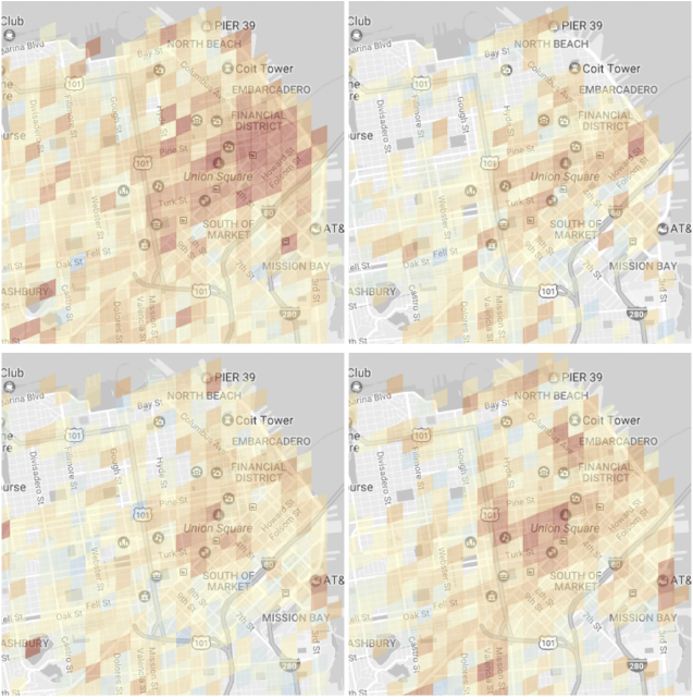
Output of our parking difficulty model in the Financial District and Union Square areas of San Francisco. Red denotes a higher confidence that parking is difficult. Top row: a typical Monday at ~8am (left) and ~9pm (right). Bottom row: the same times but on a typical Saturday.
We’re excited about the opportunities to continue to improve the model quality based on user feedback. If we are able to better understand parking difficulty, we will be able to develop new and smarter forms of parking assistance — we’re very excited about future applications of ML to help make transportation more enjoyable!

Find public toilets in the National Capital Region and Madhya Pradesh on Google Maps

Next time you are on the road and nature calls, don’t fear, Google Maps is here!
Starting today, Google will make information about thousands of public toilets in India’s National Capital Region and Madhya Pradesh available on Google Maps. Working closely with the Ministry of Urban Development, Google is adding the location, address and opening hours of over four thousand community and public restrooms to Maps, aiming to provide easy access to information to people in India and and make it convenient for them to find public restrooms.


With over four thousand listings covering Delhi NCR including Ghaziabad, Gurugram, Noida, Faridabad, Bhopal and Indore in Madhya Pradesh - Indians and visitors alike will now be able to easily find the nearest public toilet on Google Maps — both on the mobile app as well as on desktop. This service will be accessible to users both in English and Hindi language.


From now on, when you search for “public toilet” on Google Maps in an area where the service is available, you’ll see a list of restrooms near you, including the respective address and opening hours. For instance, if you’re traveling on the national highway 8 in Gurugram, locating a public toilet can be challenging and most often the only option is going to nearby restaurants and cafes. Having this information handy can make things much easier.


Public toilet listings in english
Public toilet listings in hindi


Improving sanitation is an important cornerstone of the government's Swachh Bharat campaign for a clean India. This includes making information about existing sanitation facilities easily accessible to people. The Ministry of Urban Development plans to continue to provide information about public restrooms for more cities.


We’re beginning to roll out these new local listings on Google Maps today, and they will be available to users both on desktop and Google Maps for Mobile (Android | iOS).

Posted by Sanket Gupta, Product Manager, Google Maps


Engage holiday shoppers with Promoted Places in Google Maps

During the busy holiday season, on-the-go shoppers are using their smartphones to find the perfect stocking stuffers, festive decor and gifts for loved ones. In fact, 70% of smartphone users who bought something in a store first turned to their devices for information relevant to that purchase. One in four of them also used a map through a web browser or an app before making the purchase.1 This year, a number of brands are testing Promoted Places in Google Maps to showcase special offers and announcements to drive more foot traffic to their stores.


Some users have started seeing a limited test of Promoted Places in the Google Maps for Android app. It integrates seamlessly with the browsing experience, where places of interest are visually marked with icons to help users orient themselves and explore the world around them. With Promoted Places, advertisers can improve awareness for their stores by branding their location icons with their logo. Clicks on a business’s logo will reveal promotions such as in-store sales or new products and services to help consumers decide where to go. They can also view the business’s place page to see store hours, check live updates to Popular Times, get directions, and more.


“We’re looking forward to testing Promoted Places to help us deliver a more branded and customized experience on Google Maps. It will allow us to spotlight our latest products with the goal of driving more shoppers in-store to get the full M·A·C Cosmetics experience.”
- Laura Elkins, SVP of Global Marketing

“Innovation is part of our DNA and we’re continually evaluating meaningful and contextually relevant ways to connect with our customers. Staying top of mind, especially during the competitive holiday season, requires a mix of tried and true, including breakthrough strategies. Promoted Places in Google Maps can help drive incremental store traffic and promote Walgreens as a go-to destination for small gifts. This gives us a new and different way to highlight seasonal offerings through visuals and engaging copy. Combined with the breadth of our store locations in the community, this aligns with our goals of driving loyalty and giving customers more reasons to choose Walgreens for their holiday needs.”
- Andrea Kaduk, Director of SEM & Social

"With Promoted Places, we can enhance our presence on Google Maps and give users a glimpse of our brand and coffeehouses before they even get there. Having our logo on the map helps our locations jump out and promoting our favourite menu items gives people a reason to choose us."
- Jamie McQuary, Senior Marketing Manager


This holiday season, Promoted Places will help businesses stand out to busy shoppers in the moments they’re figuring out where to go. We’re excited to test new experiences that help consumers discover nearby sales and promotions and allow businesses to reach more people through Google Maps.


1. Google/Purchased Digital Diary: How Consumers Solve Their Needs in the Moment, May 2016, Smartphone users = 1000. Offline Purchasers = 696

Source: Inside AdWords


Updating Your Holiday Hours on Google? Easy as Pumpkin Pie.

Heather Mohorn, owner of Momo’s Tree House, adds special hours on Google to let last-minute shoppers know when her business is open. “The holiday hours feature makes it easy to communicate [changes in hours] to customers,” she says. “It reduces the number of phone calls we receive to ask whether we’re open, which is nice when we’re busy wrapping those last-minute gifts on Christmas Eve.”

With Google My Business, you can update your business info on Google for free to ensure that your phone number, address, and hours of operation are correct so customers can find you this season (and beyond).

To help you make the most of the season, we put together a holiday workshop filled with tips for using the web to connect with shoppers. Preview the section on updating your holiday hours above, or watch the entire workshop at gybo.com/livestream.

For a list of step-by-step instructions on how to update your hours on Google My Business, visit our help center

We hope this is one thing you can easily check off your holiday to-do list.

Cheers,
Emily Harris, on behalf of the Let’s Put Our Cities on the Map team

Get Better Insights With Google My Business

Search engines have become the most popular way for people to find info about local businesses1 – and millions of business owners rely on Google My Business to reach new customers on Google Search and Maps. In fact, the average well-maintained Google My Business listing gets five times more views than listings which haven’t been claimed by their owners.2

Today we’re announcing some exciting changes to Google My Business, designed to let our users see where and how people are finding them on Google.

Where are people seeing your listing?
Now when you log into Google My Business, not only will you see the total number of views for your listing, you’ll also see a breakdown of how many are coming from Google Search vs. Maps.

How are people finding you?
Though some people search for you on Google by name, others search more generally for what you have to offer. (For example, “pizza restaurants in [your town].”) In fact, when researching a future purchase, 76% of people consider more than one business before making their final choice.3 Now you can see who visited your listing after searching for it directly, and who discovered your business while looking for a broader category.

To better serve our users, we’re focusing these new insights on Google Search and Maps, and removing Google+ statistics from the dashboard. With deeper insights on how people are finding your business on Google, you can make sure your efforts to maintain and promote your business are paying off. Keep your listing up-to-date by adding photos, responding to reviews, and updating your hours so that users find helpful, relevant information when they’re looking for you directly. And, if you want to reach more customers who are searching for your business category, consider promoting your listing with AdWords Express.

We hope these changes make your life a little simpler, and we’re excited to introduce even more insights into your customers' behavior soon. To learn more, check out our help center. Happy Tracking!


1. 82% of consumers use Search Engines to find information about local businesses (Google Consumer Barometer)
2. Google Internal Data
3. Google Consumer Barometer