Tag Archives: Street View

Dive into Ningaloo on Google Street View

Editor’s note: Today is World Oceans Day, a day when people around the globe celebrate the world’s oceans and the life they sustain. 
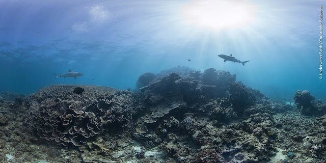
On Australia’s western coast, you will find the world’s largest fringing coral reef: Ningaloo. The Ningaloo Coast is World Heritage listed and home to 300 species of coral, 500 fish species and megafauna such as whale sharks.
Late last year, we got to walk the coastal trails and dive beneath the waves to photograph this ocean paradise--and today, on World Oceans Day, we're inviting people across the globe to gaze at the turquoise waters and virtually swim with manta ray, stingray and sharks on Google Street View
Partnering with Parks and Wildlife Service WA and not-for-profit Underwater Earth, we explored Ningaloo from every angle, collecting imagery above, below and along the coast.
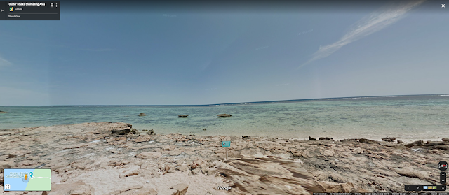
Adventurers can meander down to the shoreline of Cape Range National Park and to Oyster Stacks, within the Mandu Sanctuary Zone of Ningaloo Marine Park, before going for a digital snorkel at high tide with a rich diversity of fish--we’ve already carefully navigated the sharp oyster shells for you.
Walk the Oyster Stacks Snorkelling Area before stepping into the water. 
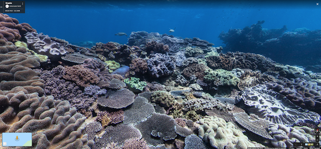
Look beneath the surface at Oyster Stacks Snorkelling Area.
Or travel up to the Muiron Islands and to Whalebone--a dive site named after whalebone that has now been washed away, grown over, or reabsorbed into the fabric of the reef, and known for its swim-throughs and overhangs. This area is exposed to the swell and waves of the Indian Ocean meaning few branching corals can grow here, so it is dominated by a myriad of hard plating corals and stunning colourful soft corals, and is a popular spot for turtles too!
Whalebone is a beautiful dive site on the western side of South Muiron Island. 
Whales, dolphins, manta rays, huge cod, turtles and whale sharks are abundant here, and this is one of many reasons this location is critical to the health of the ocean.
“We have been capturing underwater Street View imagery, partnering with Google, for over nine years. We believe in the importance of revealing precious ocean environments to the world to help educate and inspire ocean protection and conservation. Ningaloo Reef is simply too precious to lose,” said Christophe Bailhache, Co-founder of not-for-profit Underwater Earth, and underwater photographer for this Ningaloo collection.
“What an amazing opportunity to not only let Ningaloo enthral, excite and engage an even broader audience, but importantly help better understand this most beautiful and fragile of underwater wonders in the changing world we live in. Thank you Google and Underwater Earth,” said Dr Peter Barnes, Ningaloo Marine Park Coordinator.
We see this Street View capture as a chance to document the Ningaloo Coast in its current condition and keep track of how it's evolving. And by raising awareness and making sure that as many people as possible see this natural wonder, and get to understand its significance, we hope to do our bit to help protect this incredible place.

Vimy through the lens of Google Maps

Ed. Note: Today’s blog post is authored by Peter Mansbridge, the Chief Correspondent for CBC News. It’s also cross-posted to CBCNews.ca.

So here's a challenge: How do you engage a new generation with an old story about a military battle thousands of kilometers away? That's what we had to consider when we decided to re-tell the story of Vimy Ridge.
Vimy is one of those names that Canadians mention when they talk about their country's military past – names like The Plains of Abraham, Ypres, Dieppe, Normandy and many, many others. But what do they really know about what happened a century ago now on that towering ridge in northern France? Did we win, did we lose, did it really make a difference? And perhaps most important of all, why do some historians say it was in that bloody, horrific battle that Canada forged its soul and became a nation? All good questions, but how in today's world of short attention spans and handheld technology can we find new and captivating ways to answer them.
 That's why a seemingly odd pairing - a new age tech giant: Google Canada, teamed up with the supposedly staid old Mother Corp (and it's aging anchor!) and headed off to the battlefield just last month. And within hours of arrival there I found myself with a Google "Trekker" strapped to my back, walking through the restored trenches of Vimy Ridge.

Trekker in the Trenches
The "Trekker" is the same piece of technology that takes those Street View pictures of downtowns across Canada It isn’t that heavy – it weighs about twenty kilograms – but it does make you a bit top heavy and you have to be careful not to topple over! But the benefits for the viewer are terrific – the "Trekker" puts you right there, walking through history along the same paths our grandfathers and great grandfathers did exactly one hundred years ago during the Easter weekend of 1917. That's when the 100,000 soldiers of Canada's four divisions, for the first time together, launched an attack on what was seen as the most strategic ridge the Germans held in France.
The Tunnels
Beneath the trenches, the tunnels that shuttled the troops to the front lines. Today they too are restored and safe – a far cry from the muddy, rat infested and highly dangerous subways that our forefathers used to get to the fight. And here again, we bring you right there. This time using The Odyssey - 16 interconnected GOPRO cameras - created a 360 degree video of your surroundings, to give you the ultimate feel. When watching through virtual reality goggles you can point the picture where you want to go, see what you want to see. The tunnels were an engineering feat - able to keep the soldiers and the officers safe, but right at the frontlines of the battle as it raged above.

Cemetery Trekker

Canada won the battle, and at home, that became a source of considerable national pride. And for the soldiers who did the fighting, a source of considerable and justified boasting. They had done what neither the French nor the British had been able to do over months of intense fighting. But Canada paid a very heavy price. Over four days of sometimes hand to hand combat, we lost nearly four thousand soldiers, and more than seven thousand wounded. In the Canadian Vimy cemetery thousands lie side by side – they're young, sometimes very young, ages paying testament to the generation we lost.
Monument at Vimy 
The Vimy monument sits high atop the ridge that so much Canadian blood was lost to win. It is tribute to all those who died in the Great War but whose bodies were never found --- all their names, more than 11 thousand of them – are carved into the monument's walls.

Every name a compelling story of a Canadian who had travelled across the oceans to fight for "King and Country". They were fathers, sons, brothers, cousins, farmers, teachers, lawyers, labourers, hockey players, artists, preachers …. and there were kids, school students who lied about their age to do what they thought was right.

In the classroom
In the past few days the results of the Google-YouTube-CBC partnership have started to hit some select Canadian schools. Last week a grade eight class in Harriston, Ontario watched in amazement. It can be disconcerting – you really DO feel like you're there, almost reaching out to touch the trenches, the tunnels, the carved names.

And really, that's what we were hoping would happen.

Letting that new generation to virtually reach back a century and touch a moment that helped make all us, and our country, who we are.

100 years on: explore Ireland’s Easter Rising with Google


In 2016 Irish people at home and abroad will mark the centenary of the 1916 Easter Rising, when Irish people fought for their right to self governance. The Rising had a transformative impact and is recognised as the catalyst that ultimately led to the modern Ireland we have today.

The Ireland 2016 Centenary Programme includes more than 2,000 events in Ireland and another 1,000 internationally. Throughout we will remember our shared history on the island of Ireland; reflect on our achievements over the last 100 years and look ambitiously to our future.

In Dublin Rising 1916-2016, which has been launched by the Taoiseach (Prime Minister) of Ireland Enda Kenny, TD, today, Google is using its technologies to creatively enable millions of people around the world to share in Ireland’s 2016 commemorations and learn more about the events of 1916 right from their phone, tablet or computer.
This interactive Google Street View tour will allow visitors to virtually explore the city streets, events and people who shaped history 100 years ago. The tour, which is narrated by actor Colin Farrell, will bring visitors on a virtual tour around the Dublin of today, with the Dublin of 1916 overlaid.
Throughout the tour, visitors can stop at city centre locations in Dublin as they are today, hear what happened there and click to explore photos, videos and witness statements from the people of 1916. As a person stands looking at the General Post Office of today, for example, they’ll be able to see the General Post Office as it was 100 years ago, destroyed by shell fire. They’ll hear witness statements from rebels who fought there and hear the stories of all the different people involved.
President Michael D. Higgins recently said that the centenary offers all of us an opportunity to reflect on events of the past, so that we can build a future that honours the promise of equality and inclusiveness contained in the 1916 Proclamation. I want to thank the Google team, together with the historians and experts from Ireland 2016 and Century Ireland who through Dublin Rising 1916-2016 have made our history accessible and are providing everyone with the opportunity to remember our past while celebrating our present and looking forward to the future.

You can explore Dublin Rising 1916-2016 here: https://dublinrising.withgoogle.com/

Forget Middle Earth—Central and Eastern Europe’s salt mines, ice caves, mountains and castles are now on Street View

Throughout history, Europe has been a hotbed of culture, imagination and natural beauty. At Google we’re keen to share these elements with the world through our maps, so over recent months we’ve been taking all manner of Street View technologies—Trekkers, Trolleys and tripods—to capture some incredible places across the continent, focusing this time on Central and Eastern Europe. Here are a few highlights for you to explore:

Hungary
Floating down the Danube river in summertime is a wonderful thing. But now you can also check out some of Hungary’s hidden gems in Google Maps. Take a look inside the National Theatre of Pécs and explore the beautiful Basilica of Eger, the second largest church in the country. In the capital, Budapest, you can walk among the trees and rose bushes in the little-known but spectacular botanical garden near the centre of town, or even climb a hill to get away from it all.

Czech Republic
If you’re lucky enough to have been to Prague, you may have seen the fairytale sight of Prague Castle from the medieval Charles Bridge. They’re too good to miss, so we added these sites and almost 30 others in Czech Republic to Street View including the gardens of the Prague Castle, Prague’s historic center, interiors of castles such as Cesky Krumlov and Spilberk, and beauty spots like Ceske Svycarsko and Krkonose National Park.

Slovakia
In Slovakia, we’ve just released images of heritage sites like this wooden protestant church in Kezmarok and national parks like Velka Fatra and Pieniny. To get a feel for the history of the country, why not check out Branc Castle or Draskovic Castle in Cachtice? From the high turrets and battlements of the castles, you can then take a trip below ground and visit Dobsinska Ice Cave and Ochtinska Aragonite Cave which we added last year.

Romania
And finally, sink 100 meters deep into one of the most breathtaking places beneath the earth: the Turda Salt Mine, in Cluj County, Romania. Tourists around the world can take a tour of the mine—which is more than 200 years old—with our high-resolution imagery, from the comfort of their homes.


We hope you enjoy discovering some of the delights of Europe as much as we did.

Drift dreamily down the Danube with Google Street View


Since growing up near Ulm, Germany, close to where the Danube begins its epic journey from The Black Forest southeast to the Black Sea, I’ve been captivated by the majesty of the river we knew as Donau. The Danube has woven countries and cultures together for thousands of years; it has been a catalyst for economic development, a pathway for migration, and an inspiration for works of art and classical music.

Starting today, you can cruise this international waterway with Street View in Google Maps, sailing through six countries, three capitals, and enjoying many arresting landscapes along the way. To capture the imagery, the Trekker was mounted on the riverboat ms Treasures, operated by Tauck, and Scylla, its maritime partner, for cruises along the Danube and other European rivers.

Your virtual boat ride begins in Bratislava, Slovakia, where at the top of the hill, you can see Bratislava Castle. Originally settled during the Bronze Age (around 3500 BC), the castle remains a dominant sight in the area, fixed at a crucial trade point on the Danube.


Steering the ship through Hungary, the shoreline is crowded with sights of downtown Budapest. Whether you’re gazing at the famous Chain Bridge by night or the Hungarian parliament by day, the views from the boat dock will not disappoint.


On the riverbank of Croatia sits Vukovar, an old baroque city with breathtaking architecture. The Franciscan Monastery and the Church of St. Philip and Jacob overlook the city, peering down at the waters of the Danube.

The natural landscapes along the Danube and the views of the river itself may be the real highlight of the journey—try drifting through the Cazanele Mari area in Romania, where more than a third of the Danube’s waterways weave, or the Krcedinska Ada area in Serbia, where the water seems to come alive with reflections from the sky above and the terrain on either side of the riverway.


Then onwards to Bulgaria, where the Danube acts as a bordering line with neighboring Romania. The bridges that connect Bulgaria and Romania are believed to be among the shortest ways to reach Western Europe from the East.


Growing up close to the drainage basin of this great river, whenever I visit a city along the Danube it’s easy to feel connected not just to my hometown but also to everything in between. That’s why I find it even more exciting to connect all the pieces on Street View, follow the river all the way, and see what a grown-up and majestic river “my” little Danube from Ulm becomes when it flows into the Black Sea.

Hopefully you too will enjoy this journey down the Danube on Street View in Google Maps.

Stunning new Street View imagery gives tourism boost to Greece

Just in time for spring vacation planning, Street View imagery of Greece has arrived in Google Maps. Starting today, travelers can get an immersive look at the Greek landscape, unveiling some of the country’s major cities, tourist destinations, cultural and historic sites, and natural landscapes. Collected with the the Street View Trekker, a wearable backpack with a camera system on top, this imagery allows potential tourists to virtually walk through the mountainous and winding pathways of Greece, enticing them to visit in person.

This imagery update is part of Google’s commitment to help the Greek tourism sector grow, bringing more local content online as part of the Grow Greek Tourism Online initiative, which provides Greek tourism entrepreneurs free trainings and online tools to grow their business throughout the year.

To get a glimpse of some of the country’s highlights, travelers can begin their Greek journey at Meteora, which literally translates to “middle of the sky.” This UNESCO World Heritage site is one of the largest and most important complexes of Greek Orthodox monasteries in Greece, second only to Mount Athos.

Then tourists can enjoy the view of Athens from Lycabettus hill. According to Greek mythology, the Goddess Athena dropped this mountain in surprise after hearing bad news from a raven. No matter its origin, the vistas are a beautiful place to enjoy the warm, Greek sun above and the urban landscape below.

Next, travelers can cruise to a lagoon called Balos off the coast of Crete. This islet forms part of a cape through the lagoon called Cap Tigani (which means "frying pan" in Greek).

Continuing their exploration of Crete, tourists can also traverse the Samaria Gorge, a National Park and a World's Biosphere Reserve, with a length of 18 km.

This is just a sample of all the wonderful views available now in Street View in Google Maps. To explore more of the collection, view this Greek gallery.

And businesses can also benefit from Street View technology by embedding Google Maps directly into their website for free, helping to promote these locations -- whether it’s a hotel chain, tourist destinations or a local library, museum or restaurant.

Bringing some of the best of Belgium to Street View

hroughout the world, our Google Street View special collects allow users anywhere, on their mobile devices or computers, to see the world’s great sites. We’ve now just added some of the best of Belgium to the collection. Stroll through the Mardasson Memorial commemorating World War II’s decisive Battle of the Bulge or take a peek at the saxophone-filled homage to Albert Sax over the Meuse River in Dinant.


The images were taken with the Street View Trekker backpack on which is mounted a panoramic camera, and Street View Trolley, a cart with a camera system. Both tools make it possible photograph places inaccessible to Street View cars.

The project includes a shout out to three special Belgian towns: Wavre, Grobbendonk and Auderghem, the winners of Google eTown Awards in 2013. We award this prize to municipalities that benefit the most from the economic potential of the Internet.

In Wavre, we’ve captured images of the City Hall.


In Auderghem, we take a look inside the Val Duchesse castle.


In Grobbendonk, we feature the ruins of the OLV Ten Toon priory.

Life in the fast lane: lane guidance for drivers in Google Maps

Over the holiday season, if you’re driving back home to see family, or meeting up with friends, you can get where you want to go quickly and easily using voice-guided navigation in Google Maps — now with helpful lane guidance for highways in Germany, France, Italy, Spain, the UK and Ireland.


When you’re in the turn-by-turn navigation mode, we can now make sure you don’t miss your next turn or exit by showing you which lane to stay in or move to so you’ll never find yourself darting across traffic at the last minute -- or worse, driving for miles down the wrong road. When you approach a junction or exit with multiple lanes, voice guidance will suggest which lanes are best for your route. You’ll also have easy access to alternate routes while you’re navigating, so you can choose the best drive for you.

To access turn-by-turn Navigation, open the Google Maps app on Android or iPhone and get directions to a location. Then simply touch the Navigation icon to hear voice-guided directions, complete with lane guidance. (Of course, don’t forget to enable GPS on your device to use Navigation.) For more information on navigation and lane guidance, see our help page.

Safe travels!

Explore the haunted corners of Europe….if you dare

Something wicked this way comes… Whether you’re a trio of witches back from the dead or just a trick-or-treater, chances are you’re hitting the streets (or riding a broom!) on Halloween night. For those looking for an extra fright, take a tour of spooky places from around the world on Google Maps.

Start in 19th century Paris. While cheery guests listen to the beautiful arias at the Opéra Garnier, a dreary lake lies beneath the streets. Floating above the silent water, a phantom lurks. Are your eyes playing tricks on you... or is that a cloaked figure looming in the shadows?


For the holiday, we've also just released some new imagery in Italy, Romania and Czech Republic. Start with Italy's premier witchcraft museum, the Museo della Stregoneria di Triora.


Continue onto Slovakia and the Čachtický hrad, a castle where Elizabeth Báthory, a countess from the renowned Báthory family, lied. Stories describe her vampire-like tendencies (most famously the tale that she bathed in the blood of young servant girls who she killed - to retain her youth).


Conclude with the spookiest site of them all in Romania - Dracula's own Bran Castle. The Dracula's Castle was built on the edge of the Bran Pass and nowadays lures guests worldwide who wish to partake in the legend of the Count Dracula.


If these spooky spots whet your appetite for fear, get up close with some of the most frightful locations in Google Maps Gallery and find ghouls and goblins in haunted houses around the world. If you’re looking for a laugh instead of a scream, take a hayride through your local corn maze, find the perfect jack-o-lantern at your neighboring pumpkin patch, and scout the best trick-or-treat routes near you.

Now get your cauldrons bubbling and monsters mashing because after all, this is Halloween!