Tag Archives: Google Earth

Sustainable living tips for life at home

At Google, sustainability starts at home. We strive to build sustainability into everything we do. Today, we shared that we matched 100% of our energy use with renewable energy purchases for the third year in a row. On Earth Day and every day, we are committed to helping everyone build a more sustainable world, and part of that means making it easier for everyone to make environmentally friendly choices. According to Google Trends, over the past 90 days search interest in “How to live a sustainable lifestyle” has increased by more than 4,550%. To celebrate Earth Day while many of us are finding our new normal while sheltering in place, I wanted to share some of my favorite simple sustainability tips.

Save the planet, save some money

If I told you that putting your groceries away in the right place, freezing your leftovers, using the dishwasher (instead of washing dishes by hand) and turning down your water heater just a few degrees could help protect the environment, you might think that sounds too simple. But our greatest impact on the planet comes from just three things: food, water and energy usage. If we each make a few small changes, we can all make a big difference (and save money while we’re at it). Our Your Plan, Your Planet tool has more simple tips you can use in your home.

YPYP GIF .gif

Advice from Nest and Assistant


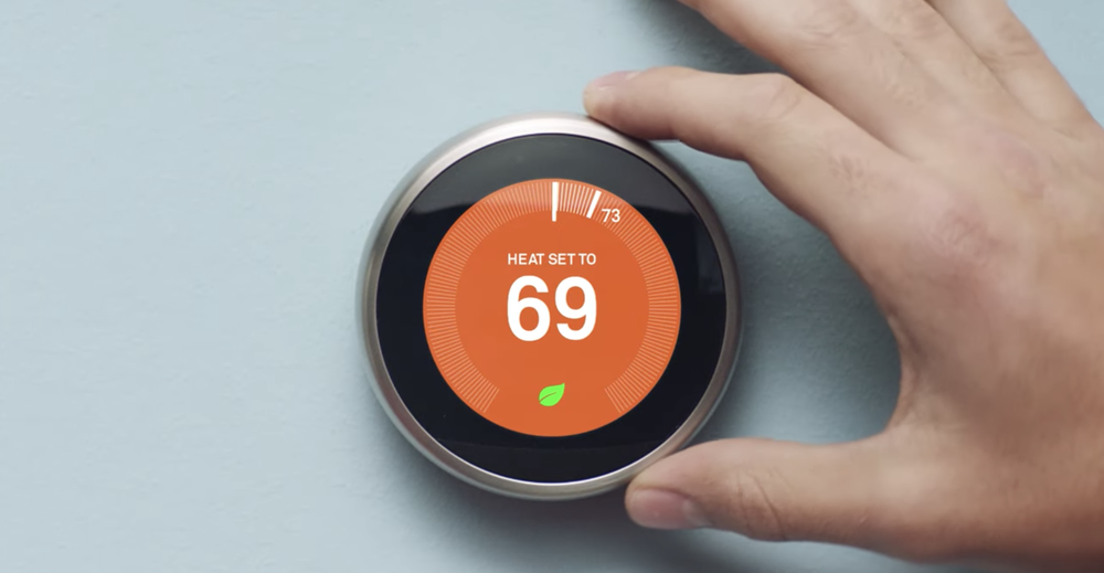
Nest Thermostat owners have saved over 50 billion kilowatt hours of energy since we first introduced the device, which comes to $3 billion in energy bill savings. In honor of Earth Day, the Google Assistant can help you save even more. Just say “Hey Google, give me an Earth Day tip” for simple ways you can save energy, like changing the temperature on your Nest Thermostat by just a few degrees until the leaf symbol pops up, so you know you’re saving energy.


Nest.png

Get the buzz on bees from today’s Doodle

See what all the buzz is about in today’s interactive Earth Day Doodle, made in collaboration with The Honeybee Conservancy. Guide your bee to pollinate flowers while learning fun facts about bees and how they help the planet. Even while social distancing, there are several things you can do to help, like supporting your local beekeeper, planting a pollinator garden or creating a bee bath.


Doodle - GIf .gif

A little “how to” help 

Recently, we’ve seen a spike in “how to” sustainability queries related to food, recycling and composting. If you’re in the U.S. or Canada, you can ask your Google Assistant how to recycle specific items and you’ll get local city and town specific answers. You can also check out our curated YouTube Earth Day playlist where you can learn how to compost, fix old clothing or turn those leftovers into a new meal. 

“How to freeze” has been a particular popular question. Here are a few of the answers I found particularly helpful:

  1. How to freeze milk? Place the milk in your freezer in its original plastic container or glass freezer-safe container. Make sure to leave room to allow the milk to expand, so remove some milk if needed. When you're ready to use the frozen milk, allow it to thaw in the fridge.

  2. How to freeze eggs? To freeze whole eggs, you simply mix the eggs together and pour the mixture into either an ice cube tray, or a freezer-safe container or bag. If you will need to use individual eggs, it would make more sense to make sure each ice cube tray holds only one egg so that you can easily separate them.

  3. How to freeze broccoli? Broccoli—florets and stems—must be blanched for effective freezing. If you freeze it raw, you'll wind up with bitter, drab green, shriveled stems. Blanching or steaming preserves the bright green color and tasty flavor. You can either blanch in boiling water for three minutes or steam for five minutes.

Enjoying planet Earth from wherever you are 

With travel plans paused, national parks temporarily closed and a collective effort to stay socially distant, the world feels a bit out of reach right now. While there’s no substitute for the real thing, virtual vacations are a great way to experience our planet from wherever you are sheltering in place using Google Earth. 

If you’re seeking natural beauty, explore the most enchanting forests, striking waterfalls, or unusual lakes around the globe. For those interested in the other creatures that share our planet, learn about the kākāpō, sea turtles or humpback whales. For anyone interested in a more scientific journey, learn about the ecosystems of the world, understand the impact of keystone species on their habitats, or learn how to be a scientist in your backyard—all you need is your smartphone.

I hope these tips are an easy way to get started. At Google, we know that individual actions collectively can make a big difference, and we’re happy to support everyone on their journey to a more sustainable life.

Explore new sites, relive old hikes for National Park Week

Every year, I try to visit a new National Park, or at least start planning my trip to one. That’s a little more difficult right now, but given that it’s National Park Week, I decided to try and keep with my tradition by using Google tools to satisfy my wanderlust.


Explore new places and parks

This year, I’m heading to g.co/nationalparks, a Google Arts & Culture project developed in collaboration with National Park Service that takes you on guided tours narrated by park rangers from the Kenai Fjords, Hawai'i Volcanoes, Carlsbad Caverns, Bryce Canyon and Dry Tortugas. I can also visit historical sites that I’ve never been to before, like Eleanor Roosevelt’s woodsy home in Hyde Park, New York or Thomas Edison’s camping sites (which, to me, look a little more like glamping). There are more than 100 Street View historical tours to choose from, and collections that let you discover Native American craft work or fossils from archeological digs. 

Afterward, I’ll take an in-depth tour of some of the National Parks of the United States and wander through a few of the most-loved ones recommended by our community of Local Guides in two popular Google Earth Voyager stories. I plan on rounding out the week with a new YouTube series from the Google Earth team that travels to National Parks across the country, literally “zooming” you into places like Elephant Hill in Canyonlands National Park and Kanarraville Falls in Zion National Park. There’s even a new Global National Parks quiz to test your geo-knowledge.

Video showing a tour of Utah's National Parks.

All of these things help an outdoor enthusiast who’s stuck inside (for the time being) to find unknown landscapes or get inspiration for their next trip. Perhaps for the most well-traveled out there, they’re a way to remember a favorite adventure. 

Or revisit old favorites

Before I venture into the unknown, I decided to take a trip down memory lane (or rather, memory trail), and re-experience some of my favorite hikes in National Parks with the help of Google Street View, and anyone can join me—starting with Bright Angel Trail in the Grand Canyon. Saving the uphill journey for the second half of a hike is something my legs will never forget, but it remains one of my favorite National Parks memories. And thanks to Street View, I can recreate the journey … with fewer water breaks, probably.

I can also make my way up Garfield Peak in Crater Lake National Park (which I hiked during a camping trip where I first met my husband) and make as many nostalgic pit stops along the way as I want.

And last summer, my family and I all vacationed in Acadia National Park. Now that we can’t physically see one another, I’m even more grateful we went. One of my favorite memories was hiking along the park’s easternmost edge, the Great Head Trail, with my husband and meeting my family on Sand Beach, a journey I’m happily retaking via Street View … and maybe on our weekly family video call, we’ll all “hike” it together.

Source: Google LatLong


Explore new sites, relive old hikes for National Park Week

Every year, I try to visit a new National Park, or at least start planning my trip to one. That’s a little more difficult right now, but given that it’s National Park Week, I decided to try and keep with my tradition by using Google tools to satisfy my wanderlust.


Explore new places and parks

This year, I’m exploring g.co/nationalparks, a Google Arts and Culture project developed in collaboration with National Park Service that takes you on guided tours narrated by park rangers from the Kenai Fjords, Hawai'i Volcanoes, Carlsbad Caverns, Bryce Canyon and Dry Tortugas. I can also visit historical sites that I’ve never been to before, like Eleanor Roosevelt’s woodsy home in Hyde Park, New York or Thomas Edison’s camping sites (which, to me, look a little more like glamping). There are more than 100 Street View historical tours to choose from, and collections that let you discover Native American craftwork orfossils from archeological digs. 

Afterward, I’ll take an in-depth tour of some of the National Parks of the United States and wander through a few of the most-loved ones recommended by our community of Local Guides in two popular Google Earth Voyager stories. I plan on rounding out the week with a new YouTube series from the Google Earth team that travels to National Parks across the country, literally “zooming” you into places like Elephant Hill in Canyonlands National Park and Kanarraville Falls in Zion National Park. There’s even a new Global National Parks quiz to test your geo-knowledge.

Video showing a tour of Utah's National Parks.

All of these things help an outdoor enthusiast who’s stuck inside (for the time being) to find unknown landscapes or get inspiration for their next trip. Perhaps for the most well-traveled out there, they’re a way to remember a favorite adventure. 

Or revisit old favorites

Before I venture into the unknown, I decided to take a trip down memory lane (or rather, memory trail), and re-experience some of my favorite hikes in National Parks with the help of Google Street View, and anyone can join me—starting with Bright Angel Trail in the Grand Canyon. Saving the uphill journey for the second half of a hike is something my legs will never forget, but it remains one of my favorite National Parks memories. And thanks to Street View, I can recreate the journey … with fewer water breaks, probably.

I can also make my way up Garfield Peak in Crater Lake National Park (which I hiked during a camping trip where I first met my husband) and make as many nostalgic pit stops along the way as I want.

And last summer, my family and I all vacationed in Acadia National Park. Now that we can’t physically see one another, I’m even more grateful we went. One of my favorite memories was hiking along the park’s easternmost edge, the Great Head Trail, with my husband and meeting my family on Sand Beach, a journey I’m happily retaking via Street View … and maybe on our weekly family video call, we’ll all “hike” it together.

Tips for learning at home with Google Earth

I'm an aunt to eight nieces and nephews, who over the past few weeks transitioned to distance learning. I also have a sister who works in Special Education and now spends half of her time meeting directly with parents, creating strategies to modify coursework and ensuring that families have the tech to support academic progress.

It hasn't been an easy adjustment, but my family is one of the many using different tools to connect with their classrooms and stay busy.

With millions of students out of school due to COVID-19, educators are rising to the challenge of teaching remotely at an unprecedented scale and parents are putting in extra time to support their kids with productive learning sessions. Adults, too, are looking to learn new things and explore the world around them from home.

While there are many resources for distance learning for both kids and adults—such as Google’s new information hub Teach from Home and the Learn@Home YouTube channel—sometimes all you need is a quick activity that doesn’t require much prep. And one place you’re sure to find that is Google Earth.

Here are four easy ways anyone can use Google Earth as a learning tool or even simply to experience new places and adventures while staying safe at home.

Take a spin around the globe with the “I’m Feeling Lucky” button

Google Earth’s “I’m Feeling Lucky” feature recreates the feeling of spinning a globe and dropping your finger down somewhere unexpected. With a click of the “dice” button, you can learn about the world and travel to unexpected destinations.

Google Earth's I'm Feeling Lucky feature

Uncover hidden gems the world over with “I'm Feeling lucky,” a feature that takes you somewhere unexpected with the click of a button.

Measure the world 

If you’ve ever wondered how far your home is from Machu Picchu or what the nautical miles between Easter Island and Hawaii are, you’re in luck. With Google Earth’s measure tool, you can easily discover the distance between locations, along paths and the area of places. Challenge yourself by changing the unit of measurement, perhaps to a smoot, and figure out how long it would take for you to walk, boogie, swim, paddle or fly to a place you love.
Google Earth's Measure Tool

Use lines and shapes to check distances and estimate sizes of different features on Earth

Explore Google Earth Voyager games and imagery

How well do you know the world’s national parks? What about the sound a penguin makes? With a few clicks, you can test your knowledge  on national parks, animal sounds or space exploration. You can even travel the world with Carmen Sandiego.
Carmen Sandiego in Google Earth

Join Carmen Sandiego in a globe-trotting game and learn about new places, cultures and customs

Students can also try a round of Earth Bingo or discover the ABCs using satellite imagery. Also, think about using Street View to put a digital spin on the game “I spy with my little eye” and look for objects in the online version of students’ streets and neighborhoods, or take the classic game for an artistic spin inside of a museum.


Visit Google’s education partner websites

Many of the authors of our Voyager stories have free online resources and activities that use Google Earth. Students can hone their geo-literacy skills and gain inspiration with National Geographic. A click of the “Share to Google Classroom” button will bring PBS Learning Media’s collection of World Explorers videos and lesson plans to an entire classroom.

Media4Math has developed a collection of resources that give mathematical principles real world context, such as the geometry of castles and circular structures.

Media4Math Triangular Structures Google Earth Voyager story

Learn how triangles are incorporated into famous buildings

Once you’ve learned about shapes, move onto sound, with the Global Oneness Project curriculum that explores the linguistic diversity and vitality of indigenous languages from speakers around the world. The curriculum is a companion to the Google Earth audio collection, Celebrating Indigenous Languages.

Meet Indigenous Speakers and Learn How They're Keeping Their Languages Alive

You can find more Google Earth resources and classroom activities on the Google Earth Education website, as well as TES, a resource hub with plenty of home learning essentials. Educators looking to connect with other teachers to share ideas on using Google Earth and mapping tools in the classroom can check out the new Google Earth Education Community Forum, and continue to follow Google Earth on Twitter and Facebook.

Google Earth education resources

1,000 of the most stunning landscapes in Google Earth

Ten years ago, I was flying over San Francisco when this strange but kaleidoscopically beautiful vista opened up outside of my tiny airplane window. When I got home, I fired up Google Earth to investigate. The aerial wonder along the southern tip of the bay turned out to be the Salt Ponds. Microorganisms reacting to the salt runoff in these waters color the pools surreal hues, and the resulting chromatic smudge is visible miles above Earth's surface. As an amateur photographer, I instinctively took a screenshot of the landscape now clear on my laptop. And with that simple act, Earth View was born.

San Francisco Bay Area Salt Ponds

Our first Earth View, the San Francisco Bay Salt Ponds

Earth View is a collection of thousands of the planet's most beautiful landscapes, seen from space. Over the last decade, the collection has been witnessed by millions around the world as wallpapers for Android devices, screensavers for Chromecast and Google Home, and as an interactive exhibit in Google Earth's Voyager. Earth View was even once featured on the world's biggest billboard to bring a little zen to Times Square during the holidays.


Today, we're making our biggest update to Earth View by adding more than 1,000 new images to the collection, bringing the total to more than 2,500 striking landscapes. The upgraded imagery features more locations around the globe and is optimized for today's high-resolution screens—featuring brighter colors, sharper images and resolutions up to 4K.

All the new imagery is available in the Earth View Gallery, as well as the popular Earth View Chrome Extension. The gallery also now features a nifty color map to help you visualize the thousands of Earth View locations, and find a landscape featuring your favorite color.

Earth View color map

Filter more than 2,500 Earth Views by color or region

To bring Earth View to life, we've collaborated with our friends at Ubilabs in Hamburg, Germany. Together over the past several years, we've refined a set of tools that help us scour 36 million square miles of satellite imagery, while maintaining fine camera control to get just the right shot. To prepare the final image, we optimize the color profile for the particular landscape, and export the final image in ultra high resolution.

Learn how we capture Earth Views

Learn how we capture Earth Views

Earth View started simply enough—a curiosity pursued by the curious. Over the decade, that tiny seed sprouted several limbs, and today this imagery has been seen by millions of people the world over. For me, Earth View's resonance is the bigger curiosity. As a species, we've only had access to views from space for the last 50 years. Yet something encoded in us long ago seems to wake up when we see the world at this unprecedented scale. 

Earth View has the power to elevate our minds from our tiny screens to outer space—the landscapes that materialize when you open a new tab or unlock your phone punctuate your day with a global looking glass. My hope then is this funny, little project—along with Google Earth as a whole—moves us to care more deeply about this strange but kaleidoscopically beautiful planet. 

Space out with Google Earth on mobile

Stars are magical. Van Gogh painted them. Shakespeare wrote about them. We make wishes on them. 

On the Google Earth team, we understand people’s desire to see stars just as much as they want to see Planet Earth. The Google Earth mobile app now offers wide views of our starry universe, just as Earth for the web and Earth Pro have done for some time.

As smartphones and tablets have become more powerful, we’ve been able to bring the quality of Earth’s web and Pro versions to most smartphones. You can now see a view of the stars as you zoom out from Earth on your phone. Rotate the globe and you’ll see images of the beautiful Milky Way, collected from the European Southern Observatory, depicting the stars as they’d appear to a space explorer at a point some 30,000 miles above the planet. 

Stars in Google Earth on a tablet device.png

Before we added the star imagery, the sky around the “big blue marble” view in Google Earth was simply black, which wasn’t very realistic. Realism is important to us—we want people using Google Earth to see our planet in context with our place in the universe. 

That’s also why we recently added animated clouds that show weather patterns around the globe, and feature space themes, like Scenes from Space and Visit the International Space Station, in our guided tours on Google Earth’s storytelling platform, Voyager.

All kinds of people use Google Earth: scientists, environmentalists, government and nonprofit workers, and global citizens who simply love exploring the planet. Whether they want to zoom in and explore Earth close-up or zoom out and see the big picture, we hope people using the Google Earth app will enjoy this new opportunity to stargaze. 

Stars in Google earth mobile -portrait.png

Using AI to find where the wild things are

According to the World Wildlife Fund, vertebrate populations have shrunk an average of 60 percent since the 1970s. And a recent UN global assessment found that we’re at risk of losing one million species to extinction, many of which may become extinct within the next decade. 

To better protect wildlife, seven organizations, led by Conservation International, and Google have mapped more than 4.5 million animals in the wild using photos taken from motion-activated cameras known as camera traps. The photos are all part of Wildlife Insights, an AI-enabled, Google Cloud-based platform that streamlines conservation monitoring by speeding up camera trap photo analysis.

With photos and aggregated data available for the world to see, people can change the way protected areas are managed, empower local communities in conservation, and bring the best data closer to conservationists and decision makers.

Wildlife managers at Instituto Humboldt take advantage of a new AI-enabled tool for processing wildlife data.

Wildlife managers at Instituto Humboldt take advantage of a new AI-enabled tool for processing wildlife data

Ferreting out insights from mountains of data

Camera traps help researchers assess the health of wildlife species, especially those that are reclusive and rare. Worldwide, biologists and land managers place motion-triggered cameras in forests and wilderness areas to monitor species, snapping millions of photos a year. 


But what do you do when you have millions of wildlife selfies to sort through? On top of that, how do you quickly process photos where animals are difficult to find, like when an animal is in the dark or hiding behind a bush? And how do you quickly sort through up to 80 percent of photos that have no wildlife at all because the camera trap was triggered by the elements, like grass blowing in the wind?


Processing all these photos isn’t only time consuming and painstaking. For decades, one of the biggest challenges has been simply collecting them. Today, millions of camera trap photos languish on the hard drives and discs of individuals and organizations worldwide.


Illuminating the natural world with AI

With Wildlife Insights, conservation scientists with camera trap photos can now upload their images to Google Cloud and run Google’s species identification AI models over the images, collaborate with others, visualize wildlife on a map and develop insights on species population health.


It’s the largest and most diverse public camera-trap database in the world that allows people to explore millions of camera-trap images, and filter images by species, country and year.


Wildlife Insights

Seven leading conservation organizations and Google released Wildlife Insights to better protect wildlife.

On average, human experts can label 300 to 1,000 images per hour. With the help of Google AI Platform Predictions, Wildlife Insights can classify the same images up to 3,000 times faster, analyzing 3.6 million photos an hour. To make this possible, we trained an AI model to automatically classify species in an image using Google’s open source TensorFlow framework. 

Even though species identification can be a challenging task for AI, across the 614 species that Google’s AI models have been trained on, species like jaguars, white-lipped peccaries and African elephants have between an 80 to 98.6 percent probability of being correctly predicted. Most importantly, images detected to contain no animals with a very high confidence are removed automatically, freeing biologists to do science instead of looking at empty images of blowing grass. 

With this data, managers of protected areas or anti-poaching programs can gauge the health of specific species, and local governments can use data to inform policies and create conservation measures. 

Wildlife Insights Animal Classifier

The Wildlife Insights Animal Classifier tool helps researchers classify 614 species.

Acting before it’s too late

Thanks to the combination of advanced technology, data sharing, partnerships and science-based analytics, we have a chance to bend the curve of species decline.

While we’re just at the beginning of applying AI to better understand wildlife from sensors in the field, solutions like Wildlife Insights can help us protect our planet so that future generations can live in a world teeming with wildlife. 

Learn more about Wildlife Insights and watch the documentary film Eyes in the Forest: Saving Wildlife In Colombia Using Camera Traps and AI. The film tells the story of a camera trapper who uses Wildlife Insights to document and preserve the biological diversity in Caño Cristales, a reserve in Colombia’s remote upper Amazon region. 

Wildlife Insights is a collaboration between Conservation International, Smithsonian’s National Zoo and Conservation Biology Institute, North Carolina Museum of Natural Sciences, Map of Life, World Wide Fund for Nature, Wildlife Conservation Society, Zoological Society of London, Google Earth Outreach,  built by Vizzuality, and supported by the Gordon and Betty Moore Foundation and Lyda Hill Philanthropies. 

How we power climate insights and action

This week, governments and NGOs from across the globe are convening at COP25, the United Nations climate conference in Madrid, to discuss the latest efforts to fight climate change. Addressing this pressing issue on a global scale requires urgent action from countries, communities and businesses. At COP25 we shared how Google is focused on building sustainability into everything that we do and making it possible for everyone to build a more sustainable world.

As cities now account for more than 70 percent of global emissions, we believe that empowering city governments with comprehensive, climate-relevant data and technology can play a critical role in igniting action. 

One way we are doing this is with partners like the Global Covenant of Mayors for Climate and Energy. We’ve brought our online tool, the Environmental Insights Explorer (EIE),to cities across the world, providing high-resolution data to measure greenhouse gas emissions (GHG) and take informed action to reduce CO2 emissions.  As of today, EIE has now expanded to more than 100 cities worldwide.

Environmental Insights Explorer: Now available in 100+ cities worldwide

Empowering local action in cities worldwide

As we look beyond our latest efforts to equip cities with more comprehensive data, we’re also exploring how we can help communities turn these insights into action at the local level.

To further accelerate climate action, Google.org is launching a new $4 million fund in collaboration with ICLEI - Local Governments for Sustainability.Grants from the fund will support nonprofits and academic institutions in Europe and Latin America that are leading data-driven climate action efforts.

The first grantee is Iniciativa Climática de México (ICM), a Mexico-based nonprofit organization that catalyzes international climate policy at the national and city levels to reduce emissions of GHGs and promotes low carbon growth in Mexico. Grant funds will be allocated to their “Hogar Solar” program. This program channels government spending on electricity towards the installation of solar panels to help increase access to power for those facing energy poverty, provide cleaner energy sources and reduce overall electricity costs. 

Data-driven initiatives like this are essential to addressing climate change and are needed at a global scale. As we fund more grantees, we will share what we learn on how to best engage in data-backed sustainability planning and action.


Translating global insights

EIE relies on anonymous, highly aggregated mapping data and standard GHG emission factors to estimate city building and transportation carbon emissions, as well as solar energy potential. We’re already seeing the early impacts of cities putting the power of EIE data behind climate plans, from bike-friendly initiatives to solar programs.

While EIE has officially published data for 100 cities, the EIE team has processed climate-relevant data across an initial sample of 3,000 cities to produce emission insights from approximately 95 million buildings and nearly 3 trillion kilometers traveled. 

Our analysis found that cities can have a huge impact in protecting our climate:

Making environmental information available will continue to be critical as cities, communities and companies worldwide band together to address climate change. We’re committed to doing our part, and want to extend our thanks to the forward-looking city officials and climate leaders collaborating with us on this project.

If you’d like to request EIE data for your city, let us know. And learn more about Google’s other sustainable efforts at sustainability.google.

Source: Google LatLong


Live from the North Pole, it’s Santa’s Village!

Good day from Santa Tracker HQ! I’m Dimplesticks the Elf, news anchor for the North Pole Broadcasting Channel. This year, our candy-cane broadcast antenna extends beyond Santa’s Village with Google as our official global rebroadcast partner.

Every day over the next three weeks, you can ask your Google Assistant for my reports from the top of the world. Just say, “Hey Google, what’s new at the North Pole?” You’ll also catch my daily North Pole Newscast alongside other minty-fresh NPBC programming like PMZ, the Reindeer Report, and Good Sleigh Today, on Google’s social channels.

What’s new in Santa’s village

And now for our top headline: Santa’s Village has a big makeover this year. Scroll down from the snowy scene up top to discover Santa’s new toy factory, his greenhouse and the reindeer gym. Just click or tap your way to over two dozen games and learning activities—including a new 3D snowbox where you can build your own wintery scene. 

Santa's Village

There are two kinds of scoops in my world: mint chocolate chip ice cream, and stories nobody else has reported. So here's some breaking news: holiday cheer is spilling over from the North Pole, and into a bunch of different Google products.

More ways to be merry 

On Google Earth, test your knowledge of holiday traditions around the world, or take a tour of the tasty treats people eat in various countries this time of year. Then jingle all the way to Image Search (best on mobile) or Tenor and look for Santa Tracker GIFs to make all your messages merry and bright. And it turns out my reporting isn’t the only sweet treat from the Google Assistant. Just ask, “Hey Google, give me a Santa joke" for some good ol’ ho-ho-ho, or say, “Hey Google, call Santa” to help him solve a wacky problem—coming up with a musical genre for his new band. Parents who want their kids to use the Google Assistant can create an account for their kids under 13—or the applicable age in your country—through Family Link.

Some of you eagle-eyed jollymakers may have observed that a few of the activities in the village are still hidden. Mrs. Claus gave me an exclusive overview of what’s to come, but because I promised to keep everything she told me under wraps, all I can say is that in a few more sleeps, there’ll be even more ways to play. Gotta keep you on your mistle-toes! 

We’re sticking with this story tighter than an elf’s tongue on a frozen pole. (Ow!) So follow me and my esteemed colleagues from the North Pole Broadcasting Channel on Google’s social accounts. Or you can search for Santa Tracker on Google for a link to a daily dose of delight.

With your Elfwitness News, I’m Dimplesticks at the North Pole!

Ladies of Landsat builds inclusivity in the geosciences

Editor’s note:Today’s post is by Morgan Crowley, a Ph.D. candidate at McGill University who studies wildfire progressions. This post is based on her recent appearance on the podcast Scene From Above. Above photo courtesy of McGill University.

Ladies of Landsat stickers

Working and studying in the geosciences can be lonely sometimes. I didn’t realize how lonely I was, and that this loneliness was tied to my identity as a woman, until I spent several days at a conference without seeing anyone else in the ladies’ room. Groups like Ladies of Landsat, which I help coordinate, connect us to fellow scientists who are gender and other minority peers so we can reach out about everything from finding research partners to starting a family.  By building up each other’s confidence and celebrating our wins, we lift, retain and attract women in the field. 

In our case, most connections happen on Twitter, although we do come together at events like the 2018 Google Earth Engine summit in Dublin. Google provided a space for us to connect while also teaching us technical skills in Google Earth and Earth Engine, so we were equipped to answer pressing scientific questions like where and when do wildfires spread in Canada, and how much air pollution does a fire produce in India

At the September 2019 Geo for Good Summit, we teamed up with Women in Geospatial, another online group promoting gender equality in geosciences, to discuss shared interests, challenges and skills. 

In 2018, I went to the ForestSAT conference and heard women like Dr. Jody Vogelerand Dr. Joanne White talk about forestry with an incredible level of depth. I got chills. It was the first time I’d talked to more than one woman at a time about this type of science. Dr. Kate Fickas, a research faculty member at the University of Utah and the brains behind Ladies of Landsat, set up a women’s networking event at a local bar. Dr. Monika Moskal brought her ground-based LiDAR unit, a surveying device, to take a picture of us. So many people came up to us and said, “I’ve never been with this many women in the field. This is incredible.”

A LiDAR selfie of the Ladies of Landsat members

A LiDAR selfie of the Ladies of Landsat members standing in a circle around the laser scanning sensor at our 2018 ForestSAT meet up at the University of Maryland. (Image credit: Dr. Monika Moskal)

It’s encouraging to see that Ladies of Landsat and Women in Geospatial are not the only groups working to make geospatial sciences more inclusive. There are amazing groups all over the world like Women in GIS, Women in GIS - Kenya, WinGRSS and She Maps. There’s also GeoLatinas, Black Girls Mapp, GeoChicas and Indigenous Maps, who support people of color in the field. And in spite of our name, Ladies of Landsat, we’re not just about lifting up women; we’re inclusive to all genders and identities. 

The work of making geosciences more inclusive is just starting—and you can play a role, too. If you read a research paper whose authors are all men, ask why. If you go to a scientific event and every panel member is a white person, speak up. Invite gender and racial minority scientists to share their work and nominate them for grants and speaking slots. The burden to change this status quo rests on people in power.