Tag Archives: Google Earth

Project Sunroof New Data Explorer Tool

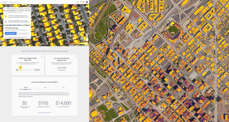
Google has always been a proponent of  clean energy, and solar power has been a central part of our vision. Over the past year, Project Sunroof has been helping homeowners explore whether they should go solar - offering solar estimates for over 43 million houses across 42 states. Solar installations today are growing rapidly, but there remains tremendous untapped potential as only a half a percent of US electricity comes from solar power.

Today we’re excited to be taking Project Sunroof a step further by launching a new data explorer tool to enable solar estimates for entire communities, in addition to individual homes, by leveraging 3D rooftop geometry from Google Earth to estimate the solar potential for millions of rooftops in America.  The tool helps communities, cities and municipalities easily visualize how many rooftops are suitable to install solar, how much power they could collectively generate, as well as how much carbon could be displaced by deploying rooftop solar at scale. Sunroof’s solar potential reports can also be easily shared amongst community members, researchers and policymakers directly from the the tool itself. Anyone can use this tool for free, by simply entering in a state, county, city, or zip code to receive a custom analysis.
Sunroof Image 1
Sunroof Image 2

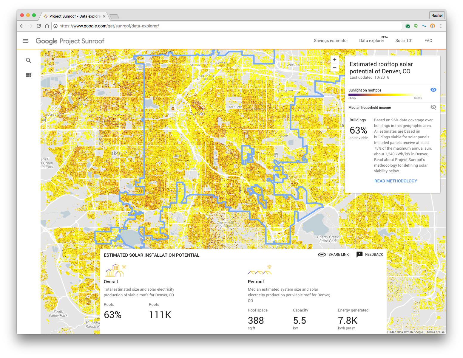
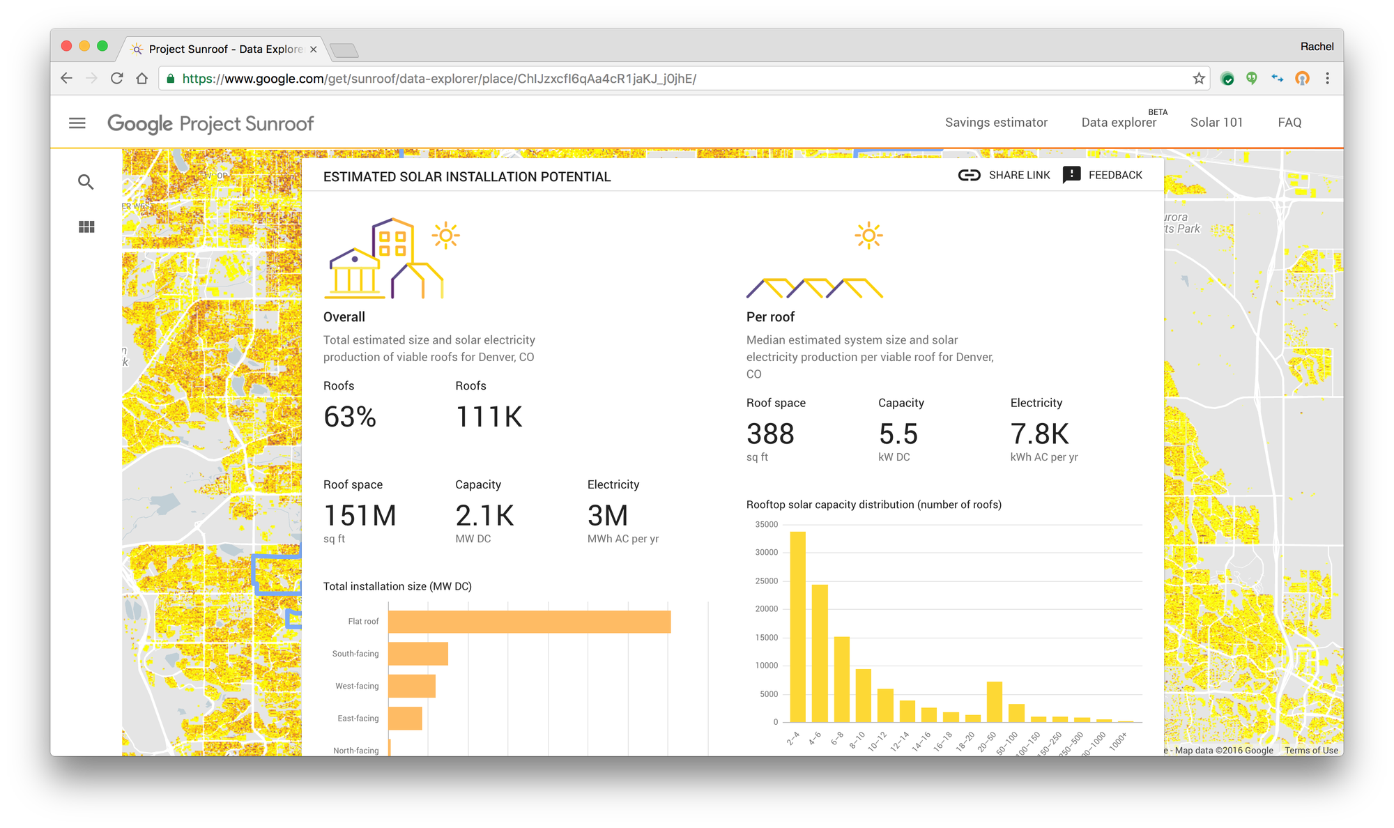
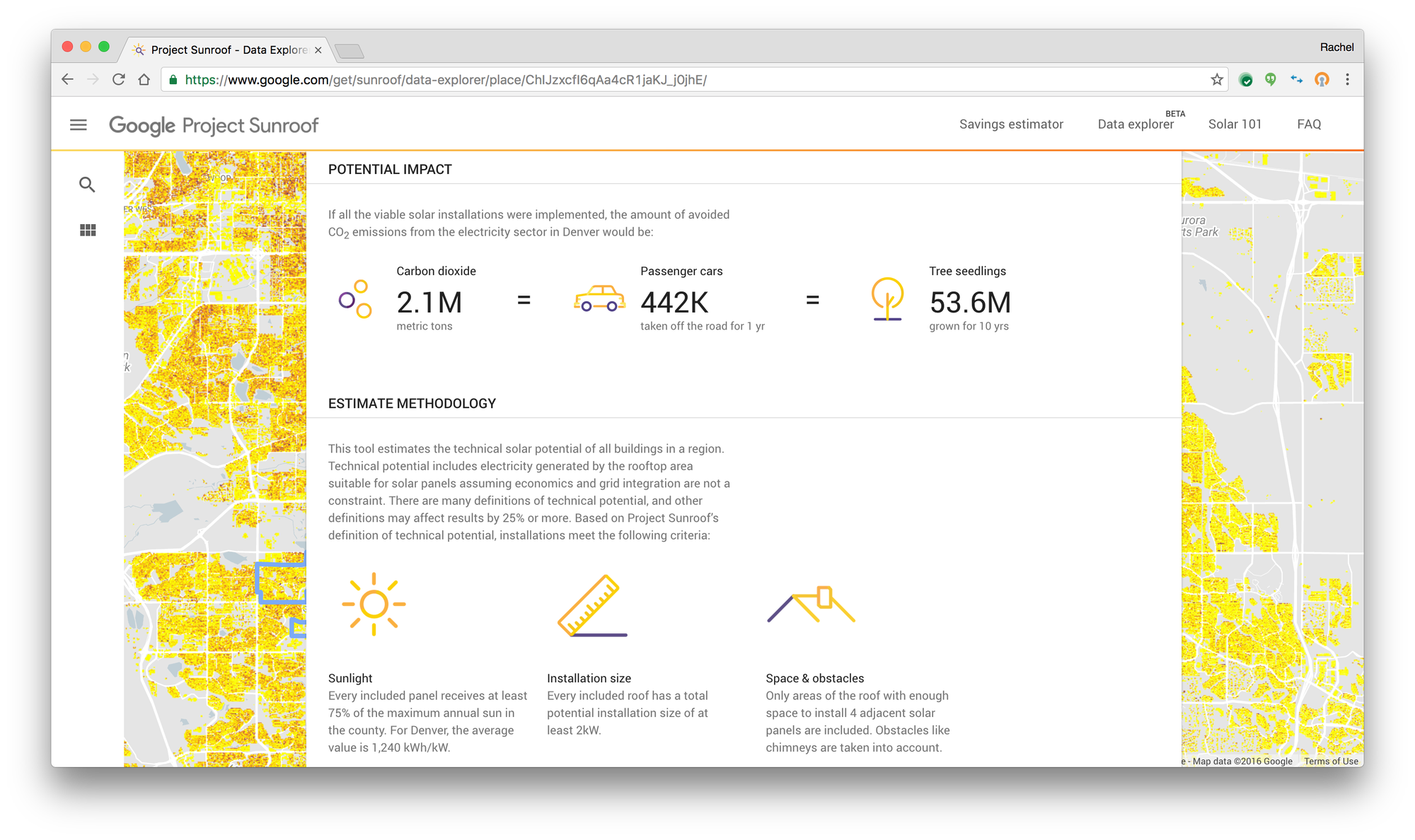
Rooftop solar is a viable option for many cities today. Sunroof’s data explorer found that in more than 90% of communities that the tool covers within 42 states nationwide, well over half the rooftops are viable for solar. Today, cities like Denver and organizations like League of Cities see great value in using the data explorer tool to evaluate whether solar can drive economic savings and growth, as well as help transition energy consumption to lower carbon sources for their communities. Here’s what they have to say;

Cooper Martin, Program Director of the Sustainable Cities Institute,  League of Cities

“Our Sustainable Cities Institute program aims to provide guidance and information for governments that want to pursue sustainability and ensuring that solar is easy, fast and cheap to install. Sunroof's Data Explorer tool can help inform city stakeholders about the opportunity of solar energy, and the work that is needed to support solar-friendly policies. ”
Sunroof Image 4

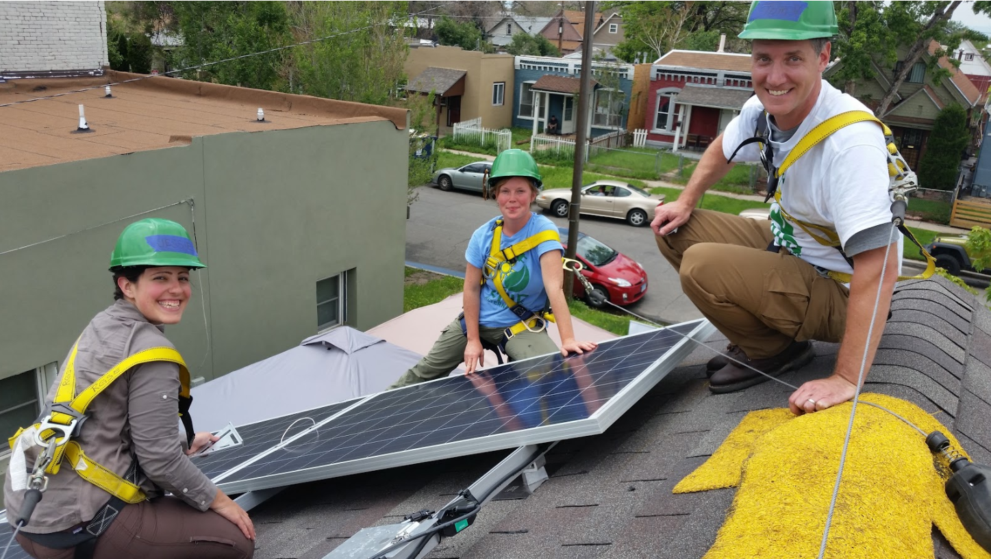
Thomas J. Herrod, Climate and Policy analyst, City of Denver

“As a City with a bold and ambitious goal of reducing 80% of Greenhouse Gas emissions by the year 2050,  Project Sunroof data is a key tool in our arsenal of potential strategies.  Rooftop solar is already a viable option within Denver, but this tool helps us refine our efforts to ensure equity in our outreach, efficiency in our efforts, and measurement in our management resources.  Of equal importance is the ability to identify where rooftop solar may not be an option – helping us identify areas where other renewable energy programs offered by our Utility can fill the gap.  We are thrilled to be able to utilize Project Sunroof in our Climate mitigation efforts and help inform our community about the bountiful resource that renewable energy can provide.”

Mark Trout, CIO, Vivint

“In previous analysis we've done, comparing Project Sunroof data estimates to actual systems performing in the field, we've found Google's information to be a highly accurate source for predicting the solar performance of a rooftop system. At Vivint Solar we are constantly focusing on how to better delight our customers and advance the solar industry through leading innovation. Project Sunroof is a prime example how technology can improve the consumer experience and accelerate solar deployment here in the US.”

The release of the data explorer tool marks another milestone across the Project Sunroof initiative where the use of Google’s high quality information has the potential to accelerate the growth of solar by capturing the public imagination, and helping communities make smarter decisions in their transition to cleaner power sources.

Source: Google LatLong


Charter schools use technology to explore history and diverse perspectives


(Cross-posted on the Google for Education Blog.)

Editor's note: Small schools are seeing great success with Google for Education tools. We spoke with educators and administrators from smaller districts across the United States to better understand how technology has helped them innovate, create more efficient processes, and make a positive impact on their students. This is the second in a series of posts where we explore the impact small schools are making on their students. To learn more about using Google for Education tools in charter schools, visit us here

Charter schools are small but mighty. While they don’t have the resources and support an entire district has, they do have ambitious goals when it comes to educating their students. We’ve encountered a number of charter schools who are leading the way in their use of technology to help students become inquisitive learners, fostering in them a desire to learn about the world around them. These charter schools are using interactive experiences to spark students’ imaginations, encouraging them to learn about international landmarks, social issues in their communities and historical events that have shaped our country. They’ve found that when students acknowledge diversity in their communities and the world, they’re encouraged to think about how they can create positive change beyond the classroom.

Greater exposure to social issues and diverse perspectives 


Teachers at Brooklyn Prospect Charter School use technology to host discussions about current events, giving every student a voice — including those who are quieter in a traditional classroom setting. For example, after one teacher shared an article with her class about conflict in the Middle East via Google Classroom, every student had the opportunity to comment and share his or her opinion via a text-based discussion in Classroom.

"The most interesting thing I learned from classmates during Google Classroom discussions is how they interpreted a book we read,” says Lena Gallager, an 11th grade student at Brooklyn Prospect Charter School. “We were able to compare our thoughts on the book and build ideas off of each other.”

“When we discussed poetry using Google Classroom, I gained a sense of others’ perspectives. Google Classroom made it really collaborative and easy to share knowledge on the topic,” says fellow 11th grader Nicolas Villarosa.

Along with having open conversations about international news, students at Brooklyn Prospect are encouraged to learn about the issues affecting their own communities. One 10th grader wanted to understand what his peers viewed as the most concerning global issues. As his end-of-the-year project for the international baccalaureate program, he created a survey in Google Forms to collect his peers’ opinions on the topic. He then used those responses as inspiration to compose a musical protest album to raise awareness for the gravity of the issues.

“Technology is helping our students become citizens of the world by cultivating their awareness and giving them a global view,” says Tyra Frederick, educational technology coordinator and high school English teacher at Brooklyn Prospect.

Interactive learning about our forefathers 


Exposing students to a global curriculum at a young age is vital for them to become well-rounded, culturally aware citizens. In addition to teaching geography and history, many schools teach classes about international current events. They also explore how historical events have shaped a city’s identity.

Westlake Charter Schools, for example, encourages students to become curious learners about their pasts. When eighth grade history teacher, Caroline Gaea, gave students an assignment to map the Manifest Destiny across the United States by dropping pins in Google Maps, students went above and beyond. They engaged in critical thinking, not only commenting on the significance of a location at a particular moment in time, but also noting the overall importance of that moment in the broader context of American history.
An eighth grade student at Westlake Charter Schools comments on a city's role in the Manifest Destiny


“My favorite part of the project was being able to be creative with information and make it fun to read,” says Maya, an eighth grader at Westlake Charter Schools. “There were so many different ways to learn the same thing, so each student was able to customize their experience.”

Even after that assignment was complete, students took the initiative to dive deeper into the topic — they impressed their teacher with a historical map of the United States, using layers in Google Maps to show the 1803 Louisiana Purchase.
Westlake Charter Schools students create a collaborative, historical map in Google Maps
“This project made me even more excited to learn about American history because the Google tools give us an opportunity to express our knowledge on a whole new level,” says Grace, an eighth grader at Westlake Charter Schools.

“Mapping out the places and presidents of that time period made it feel like we were there because we understood it better,” says Jada, an eighth grader at Westlake Charter Schools.

Taking virtual field trips around the world


Students at Challenge to Excellence Charter School are using technology to travel outside of the classroom. When a second grade student traveled to India for a family vacation, his classmates virtually went with him. The student took a tablet so he could take pictures of his trip and share them with the class. Back in the classroom, students researched the landmarks that their classmate was visiting and had a real-life view of places like the Taj Mahal using Google Earth.

“It was so fun to be able to take my tablet with me to India to take pictures and then send them to my class,” says Arushi, a second grader at Challenge to Excellence Charter School. “Mrs. Stewart shared the pictures with the class before I even got back home.”

“When the student came back from his trip, his classmates showed him all the pictures and information they’d collected,” says Julie Stewart, technology integration specialist at Challenge to Excellence Charter School. “You could feel their excitement — the project helped take my students outside the four walls of the classroom.”

These are just a few of the ways charter schools are inspiring students to think big and learn about experiences beyond their own. What do you think? What are the best ways for schools — public, independent or charter — to approach a global education?

Charter schools use technology to explore history and diverse perspectives


Editor's note: Small schools are seeing great success with Google for Education tools. We spoke with educators and administrators from smaller districts across the United States to better understand how technology has helped them innovate, create more efficient processes, and make a positive impact on their students. This is the second in a series of posts where we explore the impact small schools are making on their students. To learn more about using Google for Education tools in charter schools, visit us here

Charter schools are small but mighty. While they don’t have the resources and support an entire district has, they do have ambitious goals when it comes to educating their students. We’ve encountered a number of charter schools who are leading the way in their use of technology to help students become inquisitive learners, fostering in them a desire to learn about the world around them. These charter schools are using interactive experiences to spark students’ imaginations, encouraging them to learn about international landmarks, social issues in their communities and historical events that have shaped our country. They’ve found that when students acknowledge diversity in their communities and the world, they’re encouraged to think about how they can create positive change beyond the classroom.

Greater exposure to social issues and diverse perspectives 


Teachers at Brooklyn Prospect Charter School use technology to host discussions about current events, giving every student a voice — including those who are quieter in a traditional classroom setting. For example, after one teacher shared an article with her class about conflict in the Middle East via Google Classroom, every student had the opportunity to comment and share his or her opinion via a text-based discussion in Classroom.

"The most interesting thing I learned from classmates during Google Classroom discussions is how they interpreted a book we read,” says Lena Gallager, an 11th grade student at Brooklyn Prospect Charter School. “We were able to compare our thoughts on the book and build ideas off of each other.”

“When we discussed poetry using Google Classroom, I gained a sense of others’ perspectives. Google Classroom made it really collaborative and easy to share knowledge on the topic,” says fellow 11th grader Nicolas Villarosa.

Along with having open conversations about international news, students at Brooklyn Prospect are encouraged to learn about the issues affecting their own communities. One 10th grader wanted to understand what his peers viewed as the most concerning global issues. As his end-of-the-year project for the international baccalaureate program, he created a survey in Google Forms to collect his peers’ opinions on the topic. He then used those responses as inspiration to compose a musical protest album to raise awareness for the gravity of the issues.

“Technology is helping our students become citizens of the world by cultivating their awareness and giving them a global view,” says Tyra Frederick, educational technology coordinator and high school English teacher at Brooklyn Prospect.

Interactive learning about our forefathers 

Exposing students to a global curriculum at a young age is vital for them to become well-rounded, culturally aware citizens. In addition to teaching geography and history, many schools teach classes about international current events. They also explore how historical events have shaped a city’s identity.

Westlake Charter Schools, for example, encourages students to become curious learners about their pasts. When eighth grade history teacher, Caroline Gaea, gave students an assignment to map the Manifest Destiny across the United States by dropping pins in Google Maps, students went above and beyond. They engaged in critical thinking, not only commenting on the significance of a location at a particular moment in time, but also noting the overall importance of that moment in the broader context of American history.
An eighth grade student at Westlake Charter Schools comments on a city's role in the Manifest Destiny

“My favorite part of the project was being able to be creative with information and make it fun to read,” says Maya, an eighth grader at Westlake Charter Schools. “There were so many different ways to learn the same thing, so each student was able to customize their experience.”

Even after that assignment was complete, students took the initiative to dive deeper into the topic — they impressed their teacher with a historical map of the United States, using layers in Google Maps to show the 1803 Louisiana Purchase.
Westlake Charter Schools students create a collaborative, historical map in Google Maps
“This project made me even more excited to learn about American history because the Google tools give us an opportunity to express our knowledge on a whole new level,” says Grace, an eighth grader at Westlake Charter Schools.

“Mapping out the places and presidents of that time period made it feel like we were there because we understood it better,” says Jada, an eighth grader at Westlake Charter Schools.

Taking virtual field trips around the world


Students at Challenge to Excellence Charter School are using technology to travel outside of the classroom. When a second grade student traveled to India for a family vacation, his classmates virtually went with him. The student took a tablet so he could take pictures of his trip and share them with the class. Back in the classroom, students researched the landmarks that their classmate was visiting and had a real-life view of places like the Taj Mahal using Google Earth.

“It was so fun to be able to take my tablet with me to India to take pictures and then send them to my class,” says Arushi, a second grader at Challenge to Excellence Charter School. “Mrs. Stewart shared the pictures with the class before I even got back home.”

“When the student came back from his trip, his classmates showed him all the pictures and information they’d collected,” says Julie Stewart, technology integration specialist at Challenge to Excellence Charter School. “You could feel their excitement — the project helped take my students outside the four walls of the classroom.” These are just a few of the ways charter schools are inspiring students to think big and learn about experiences beyond their own. What do you think? What are the best ways for schools — public, independent or charter — to approach a global education?

Bring the world’s changing forests inside the classroom

Forests are the mighty lungs of our planet. They absorb carbon dioxide, and emit oxygen on which all people and animals on Earth rely. For the sake of our future, it is critical that all people, including the next generation, understand our global forests in order to manage them sustainably. Today, Science in the Classroom, Dr. Matt Hansen of the University of Maryland, and Google Earth Engine are presenting Global Forest Change Explorer to help engage young people in forest conservation.

Changing Forests_2.png
Fly to different parts of the world and compare data. 

The Global Forest Change Explorer website contains maps that are available for interactive analysis as well as an accompanying activity worksheet. The Explorer Tool allows students to quickly visualize trends in forest loss and gain, compare different countries and ecoregions, and apply the forest data to try to predict underlying causes where there is significant change in forest density. The Explorer Tool relies on open data that is used by remote sensing and GIS professionals in their work.

A number of years ago, Dr. Matt Hansen and a team of researchers at the University of Maryland turned to Google Earth Engine to map high-resolution global forest cover with Earth Engine's cloud-based image processing and computing. The team mapped global forest loss and gain from 2000 to 2012 at 30-meter resolution for the entire globe. In 2013, the methods and results were published in Science Magazine and online for everyone to explore. These findings are now an important part of the website Global Forest Watch, which gives governments and decision makers free access to the data and tools required to monitor and manage their forests. 

Changing Forests_4.png
Dr. Matt Hansen presenting at the World Economic Forum 

Science in the Classroom (SitC) thought this was great research to bring into the classroom and make available to anyone online. SitC packages annotated research papers with supplemental teaching materials to help pre-college and college students understand the structure and workings of scientific research. SitC and Google Earth Engine built the Global Forest Change Explorer to make Dr. Hansen’s data accessible to a younger audience.

Changing Forests_3.png

We live in a dynamic world where the pressures of population growth increasingly impact and threaten our forests. However, as technology, open data, and people continue to mobilize, we are given more tools to research the health of our planet. Educators can easily flip their classrooms into science labs by combining SitC materials with Global Forest Change Explorer. With these tools, students will leave sessions with richer understanding of environmental change, more curiosity, and a desire to actively participate in protecting our forests.

Get started with Global Forest Change Explorer today!

How technology can help us become more sustainable

We want to create technology that helps millions of others understand our changing world and live more sustainably—whether it’s connecting people with public transit routes, or using the data that powers Google Earth to help you see if your roof is good for solar panels. In honor of Earth Day this month, we’ve gathered together some of the ways Google can help you reduce your everyday emissions and learn more about preserving our world.

Monitoring forests and wildlife

Google Earth satellite technology gives scientists and environmentalists a way to measure and visualize changes of the world on both land and water. This technology can have great impact on monitoring endangered animal populations around the world. For example, with the help of Global Forest Watch, powered by Google Earth Engine, scientists at the University of Minnesota are suggesting that wild tiger populations may rebound by 2022, due to the efforts to restore tiger habitats in key regions.

Going solar

Looking to generate clean energy savings with solar power on your home? Check out Project Sunroof, a solar calculator that estimates the impact and potential savings of installing solar on the roof of your home. Taking Google Earth imagery and overlaying annual sun exposure and weather patterns, Sunroof is able to assess viable roof space for solar panel installation, estimate the value of solar and savings based on local energy costs, and connect you with providers of solar panels in your area.

As of this week, Sunroof expanded to 42 states across the U.S. (from 10 states in December), which makes imagery and data available for a solar analysis to 43 million rooftops. We’re also working with organizations like Sierra Club and their Ready for 100 campaign to help analyze the solar potential of cities across the US. 

LatLong_Duo.jpg
Project Sunroof shows you the solar potential of your home and city, allowing you to realize its renewable potential. The image on the right shows how much sunshine Denver, CO residents can capture with solar.

Measuring air pollutants 

For the past few years, Google Earth Outreach and the Environmental Defense Fund (EDF) have been working together to map methane leaks from natural gas pipelines under our streets. Since methane is a very potent greenhouse gas (GHG), even small leaks can add up to big emissions that can hurt our climate. By attaching methane analyzers to select Street View cars, we’ve driven more than 7,500 miles and have mapped 4,200+ leaks in 10 cities. What we found ranges from an average of one leak per mile (in Boston) to one leak every 200 miles (in Indianapolis), demonstrating the effectiveness of techniques like using plastic piping instead of steel for pipeline construction. We hope utilities can use this data to prioritize the replacement of gas mains and service lines (like New Jersey’s PSE&G announced last fall). We’re also partnering with Aclima to measure many more pollutants with Street View cars in California communities through this year. Anyone can explore the maps at www.edf.org/methanemaps.

Mapping the invisible

Technology is crucial to increasing energy efficiency, raising climate change awareness, and sustainability efforts. To learn more about what you can do to help, take a moment to explore our Google Earth Outreach site, where these tools and more are described in depth.

Google Earth turns 10 today

When Google Earth was first introduced 10 years ago, it immediately stole my heart. Beyond the freedom to fly anywhere in the world, I was captivated by the ability to paint and visualize geographic data on this incredible global canvas.

Drawn to datasets backed by real human stories, I started making my own maps with KML a few weeks after Earth’s release in 2005. For my master’s degree, I used Google Earth to build a virtual representation of a high-tech biological research reserveVint Cerf saw my work, which eventually led to a job on the Google Earth Outreach team, turning my passion for telling stories with maps into a career.

2005 was the beginning of Google Earth’s evolution, as well. In August of that year, Hurricane Katrina showed us how useful mapping tools like Earth could be for crisis response efforts. Rescue workers compared before and after Satellite imagery in Google Earth to better locate where people were stranded. And in the years after, with more than 2 billion downloads by people in nearly every country in the world, Earth has enabled people to discover new coral reefs, journey to the Moon and into deep space, find long-lost parentsclear landmines and much more.

Katrina.width-1000.jpg
Google Earth images of Gulfport, Mississippi's shoreline before and after Hurricane Katrina

The ability to empower groups as diverse as school children and NASA scientists to learn more about the world is what I love about Google Earth. It has the potential to make the planet a far more connected place, if you take the time to explore, discover and share what you learn. So to celebrate how far Google Earth has come and our leap into the next 10 years, we’ve created a few new ways to help you better see places from around (and above) the world.

Voyager

The world is a big place, and it can be hard to know where to begin your virtual journey. Now you can jump straight to the newest and most interesting imagery around the globe with a new layer, Voyager, available in desktop versions of Google Earth.

Venetian-Arsenal.width-1600_L3AmiIH.jpg
Different imagery types in Voyager are shown by color

In this first edition of Voyager, you’ll find five sections to explore:

  • Street View: highlights from Street View, including the Taj Mahal and the Grand Canyon
  • Earth View: striking landscapes around the globe as seen from space (more below)
  • 3D cities: a showcase of cities and towns available in photorealistic 3D (don’t forget to tilt!)
  • Satellite imagery updates: a map of our most recently published satellite imagery
  • Highlight tour: with thousands of Voyager locations to choose from, take a quick tour of a few to whet your appetite
Gompa.width-1600.png
The Kemgon Gompa—available in the Street View layer—is a Buddhist monastery in Lukla, Nepal

Earth View

Looking at our planet from above is not only a reminder of how interdependent our human and natural ecosystems are—it also lays bare the Earth’s staggering and often surreal beauty.

Hammar-Marshes.width-1280_TlUxzsu.png
The Hammar Marshes of Iran are an uncharacteristic yet beautiful wetland feature in the otherwise arid climate

Earth View is library of some of the most striking and enigmatic landscapes available in Google Earth. It started as a 20 percent project last year by a few Googlers who enjoyed scouring satellite imagery for these gems. These images soon made their way onto Android phones, Chromecast and Chromebooks as a distinctive kind of wallpaper.

Cuba-via-Earth-View.width-1280_wkO6QVZ.png
Islands surrounding Cuba seen in the Earth View Chrome Extension

For Earth's 10th birthday, we're expanding the Earth View collection to 1,500 landscapes from every continent and ocean and making it accessible to even more people. The new imagery is available with an updated version of our Chrome extension and a new web gallery. Download high-resolution wallpapers for your mobile and desktop devices, or better yet, print them up for your walls!

Ningaloo-Earth-View.width-1248_5xAg4hb.png
The coastline near Ningaloo, Australia in the new Earth View web gallery

Thank you for the last 10 years exploring your world with Google Earth. We hope Voyager and Earth View will unlock a new perspective on our planet. We look forward to seeing what the next decade brings!

Source: Google Chrome


From Lake Tanganyika to Google Earth: Using tech to help our communities

Today we're joined by Dr. Jane Goodall, primatologist and founder of the Jane Goodall Institute and Roots & Shoots program. In this post, Dr. Goodall shares her thoughts on how today’s technology can enable more people around the world to make a difference in their communities. Join Dr. Goodall for a celebratory Birthday Hangout on Air today at 11 a.m. PDT/2 p.m. EDT. -Ed.

When I first set foot on the shores of Lake Tanganyika in 1960 to study chimpanzee behavior, I carried with me notebooks, pencils and a pair of second-hand binoculars. I was, at the time, a young woman with no scientific training, but had a strong passion for learning about animals in Africa. In later years I founded the Jane Goodall Institute, dedicated to preserving the habitat of chimpanzees and other animals worldwide.
The author connects with a member of the Kasakela chimpanzee community in Gombe. 
Photo courtesy of JGI.

Today, the mapping technology available to all of us is completely changing the potential for animal and environmental research. My trip in 1960 would have looked quite different today. You have much more power at your fingertips, and you don't even have to leave your home. Tools like Google Earth let you visit the shores of Lake Tanganyika with just a few keystrokes. And in Gombe, local villagers are using Android smartphones and tablets, in conjunction with Google Maps Engine and Earth Engine, to monitor changes in the forest habitat that affect chimpanzee populations. Technology makes it so easy for people to find and share information and to understand the world around them. And once we understand, we can start to foster positive change.
The Jane Goodall Institute engages local communities from Tanzania, Uganda and across Africa to collect data on forests, wildlife and human activities using Google Android handheld devices. 
Photo courtesy of JGI/Lilian Pintea.

That’s one of the reasons we started the Roots & Shoots program to connect young people with the knowledge and tools they need to solve problems in their communities. The projects undertaken by these young people help them learn important science, technology, engineering and math (STEM) skills while developing real leadership capabilities. Today, Roots & Shoots is launching a new community mapping tutorial for young people to help them use digital mapping technology to identify and address needs in their community. If you’re an educator, we offer online professional development to help you fit our youth leadership model into your classroom and curriculum. You can sign up for the Roots & Shoots MOOC to learn more.
Roots & Shoots groups from Uganda, Tanzania, and Republic of Congo share their projects.
There are more than 8,000 Roots & Shoots groups in 136 countries. Photos courtesy of JGI.

Today, on my 80th birthday, my wish is for young people around the world to think about the ways you can use technology to learn more about the wonderful world we share. Then, to take action, and inspire others to do the same. You have the power to do so much more than I did in 1960, to spark change I could only imagine back then. And you can do it no matter where in the world you are.