Tag Archives: Sustainability

New ways to make more sustainable choices

Search interest in terms like electric vehicles, solar energy and thrift stores reached new highs globally over the past year — suggesting that people are looking for ways to practice sustainability in their daily lives. That’s a trend we love to see.

Averting climate change requires all of us to act. At Google, we aim to make our operations more sustainable (like our goal to achieve net-zero emissions across all of our operations and value chain by 2030), and also make it easier for people and businesses to make more sustainable choices. At our Search On event, we’re sharing new ways Google can help you be more sustainable.

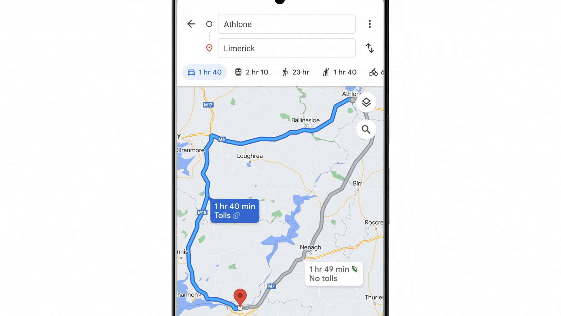
Find more efficient cars and eco-friendly routes

If you’re in the market for a new car, you’re probably looking to lower your fuel costs and emissions. Over the next few days, we’ll start to show the annual fuel cost for cars in search results. We’ll also show emissions estimates, so you know how a particular model you have your eye on compares to similar ones.

Animation showing the annual fuel cost of a Toyota RAV4 Hybrid compared to typical cars.

If you’re looking to buy an electric vehicle — which more than a quarter of new car buyers are — we’ll soon show estimated costs, range and charging speeds for electric vehicle models. Plus, you’ll be able to easily find public charging stations near you that are compatible with each electric vehicle. For U.S. shoppers, we’ll also show available federal tax incentives, which make the switch to electric cars even more appealing.

Animation showing the charging speeds of a Ford F-150 Lightning.

To help save money on gas, drivers have also been using our eco-friendly routing feature, which helps people find the most fuel-efficient routes using insights from the U.S. Department of Energy’s National Renewable Energy Laboratory and data from the European Environment Agency. We’re now making it easy for companies — like delivery or ridesharing services — to become more sustainable by using the same eco-friendly routing capability in their apps. Check out our blog post about Maps updates to learn more about this feature.

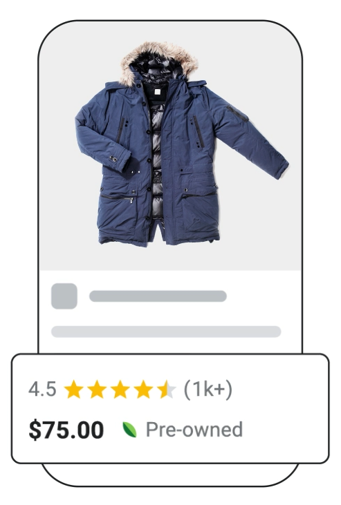
Shop pre-owned items

Whether it’s sprucing up your wardrobe with new items or digging up hidden gems from a few seasons ago, clothing choices have an impact on emissions and waste. After all, clothing is responsible for 10% of global carbon emissions. Buying pre-loved items is a small action you can take to live more sustainably. Later this year on Search, we’ll highlight which products are pre-owned, making it easier than ever for you to make sustainable choices when shopping and maybe even save some money!

A jacket with a pre-owned label and green leaf icon.

Brussel up a healthier dinner

Some food ingredients are more sustainable than others. But it's not always easy to find out how the environmental impact of chicken compares to fish or how eggs compare to tofu.

Soon, when you search for certain recipes like “bean recipes” or “broccoli chicken,” you can see how one choice compares with others thanks to ingredient-level emissions information from the United Nations. This feature will soon be available worldwide to English language users.

A search for panang curry with tofu, showing how tofu compares to other proteins in terms of emissions.

Whether you’re buying pre-owned products and planning your next meal or road trip, these small changes can add up to a big impact. The future of our planet — and everyone on it — deserves nothing less.

4 new updates that make Maps look and feel more like the real world

Google Maps has always pushed the boundaries of what a map can do. Features like live traffic transformed how people get from point A to B, and insights like busyness information changed the way people make decisions about where to go. At Search On, we shared how we’re reimagining Google Maps yet again, with a visual and intuitive map that allows you to experience a place as if you’re there — all thanks to the newest advancements in computer vision and predictive models.

Get a vibe check before you visit ?✅

If you’re visiting a new neighborhood, it can be hard to figure out what's worth exploring, what’s new, and what the local gems are. Soon, with our new neighborhood vibe feature, you’ll be able to select a neighborhood and see the most popular spots come to life thanks to helpful photos and information from the Google Maps community right on the map. Say you’re on a trip to Paris — you can quickly know if a neighborhood is artsy or has an exciting food scene so you can make an informed decision on how to spend your time. To determine the vibe of a neighborhood, we combine AI with local knowledge from Google Maps users who add more than 20 million contributions to the map each day — including reviews, photos and videos. Neighborhood vibe starts rolling out globally in the coming months on Android and iOS.

Alt text: Still images of Google Maps’ new neighborhood vibe feature, which shows photos and reviews on top of the map

See popular places right on the map with neighborhood vibe.

Now live: 250 landmark aerial views around the ?

At I/O, we introduced immersive view, an entirely new way to explore the world, letting you see stunning multi-dimensional views of an area with critical information like the weather, traffic and busyness layered on top. Today, we’re launching over 250 photorealistic aerial views of global landmarks that span everything from the Tokyo Tower to the Acropolis — marking a significant step toward a more immersive map.

GIF of Google Maps aerial views for the Tokyo Tower, Acropolis, and Empire State Building

See 250 photorealistic aerial views of global landmarks.

Using predictive modeling, immersive view automatically learns historical trends for a place to determine what an area will be like tomorrow, next week and even next month. So if you’re visiting San Francisco and want to visit Oracle Park, you’ll have all the information you need to plan your day. You’ll be able to see where the parking lots and entrances are and if the weather will be chilly on game day so you can bring a jacket. Need to find a bite to eat after the game? We make it easy to experience what restaurants are like nearby with the ability to glide down to street level, peek inside and know how busy it’ll be. Immersive view rolls out in the coming months in Los Angeles, London, New York, San Francisco and Tokyo on Android and iOS.

A breakthrough for Live View ?

Beyond helping you experience a place before you visit, we’re also changing the way you explore it in the moment. Three years ago, we reinvented the way people orient themselves while walking with Live View, which overlays arrows and directions right on top of your world so you don’t get lost. Now, we’re expanding the underlying technology — the first of its kind to be available broadly — to launch a new feature called search with Live View, which helps you find what’s around you more intuitively.

Say you’re heading to an outdoor market and need to take cash out. With search with Live View, simply lift your phone to search and instantly see the ATMs in an area. You can also spot different places — including coffee shops, grocery stores and transit stations. We'll show you business hours and how busy a place is, and you can tap on any location to view more details, like what services the barber shop down the street offers. Search with Live View starts rolling out in London, Los Angeles, New York, San Francisco, Paris and Tokyo in the coming months on Android and iOS.

GIF of search with Live View, which shows how you can lift your phone to find places like ATMs overlaid on top of the map

Lift your phone to explore nearby places with search with Live View.

Helping companies and developers operate more sustainably ♻️

Recently, we launched eco-friendly routing in the U.S., Canada, and Europe, which uses a new routing model to let drivers see and choose the most fuel-efficient route to their destination, using insights from the U.S. Department of Energy’s National Renewable Energy Laboratory and data from the European Environment Agency. Since launching in the U.S. and Canada, eco-friendly routing has helped remove an estimated half a million metric tons of carbon emissions — the equivalent of taking 100,000 fuel-based cars off the road. To drive an even bigger impact, we’ll soon expand this same technology to third-party developers through Google Maps Platform.

This means that companies of all sizes and industries — like delivery or ridesharing services — will have the option to enable eco-friendly routing in their apps and measure fuel consumption and savings for a single trip, multiple trips, or even across their entire fleet to improve performance. Developers will even have the ability to select an engine type to get the most accurate fuel or energy efficiency estimates when choosing an eco-friendly route. Eco-friendly routing for developers will be available in preview later this year, wherever it’s available on Google Maps.

With today’s announcements, we’re building a visual-first Maps experience that helps everyone explore and navigate the world more naturally — while getting there more sustainably.

New Chromebooks built with sustainability in mind

The technology we use has a meaningful impact on the environment. And given how much people rely on laptops in both their work and personal lives, we’ve teamed up with our partners to build some more sustainable options. These new Chromebooks are made with recycled materials and are easy to customize, repair and upgrade.

New devices built with the planet in mind

The new Framework Laptop Chromebook Edition, made of 50% post-consumer recycled aluminum, is the most customizable Chromebook yet. It’s durable, powerful, thin, light and designed to last. You can upgrade the laptop’s memory and storage and replace key parts like the screen, battery and webcam without needing to replace your entire laptop. And if you ever want to switch up your Framework Laptop’s look, simply swap out the bezel with different colors. You can pre-order this device starting today.

A laptop on a desk is being repaired.

The Framework Laptop Chromebook Edition is easy to upgrade and repair.

We also recently announced the Acer Chromebook Vero 514, which incorporates post-consumer recycled plastic into its design, including recycled ocean-bound plastic in its internal fan housing and touchpad. It’s durable and comes with molded pulp packaging made with recycled paper, cardboard and other natural fibers. The packaging can also be reused as a laptop stand.

An Acer laptop with a green, wavy desktop background. A gray bubble zooms in on the laptop and shows the text “post consumer recycled.”

The Acer Chromebook Vero 514 incorporates post-consumer recycled plastic.

Earlier this year, we launched the high-performance HP Elite Dragonfly Chromebook that brings together powerful capabilities and sustainable design. It uses recycled materials throughout its body, including recycled magnesium in the top, recycled aluminum in the bottom and recycled plastic in the keyboard’s keycaps.

A laptop with a red and purple wavy desktop background. The desktop shows a menu of apps, including Gmail, Docs, Sheets and Meet.

The HP Elite Dragonfly Chromebook.

More ways to stay sustainable with Chromebooks

Chromebooks are power efficient, providing up to 12 hours of battery life on a full charge. They’re also designed to last, with automatic updates for up to eight years that keep it running fast and secure. And all the Google apps that run on it — like Drive, Photos and Gmail — operate on Google Cloud, the cleanest cloud in the industry.

It’s also easy to share a Chromebook with multiple family members so you can limit the number of devices in your household. You can add multiple profiles on one Chromebook — which keeps each person’s files, apps and settings separate — to personalize your device the way you like it, even when it’s shared.

Don’t have a Chromebook yet? Modernize your existing device with ChromeOS Flex. The cloud-first, fast and secure operating system for PCs and Macs gives you the sustainability-focused benefits of ChromeOS at no cost.

And when you’re ready to let go of your old Chromebook, we’ve made it easier to safely recycle them. Simply search for “electronics recycling near me” on Google to find verified services that can recycle your laptop for you.

GIF showing a Google search for “electronics recycling near me” and a result in Google Maps.

Google Search can help you find electronics recycling locations near you.

From launching sustainable devices with our partners to helping educational institutions repair their old Chromebooks (from Lenovo, Acer, and now, CTL), we’ll continue working toward a more sustainable future.

More ways to drive sustainably and save money with Google Maps

Imagine you’re planning a day trip from your home in Athlone, Ireland over to Limerick – over an hour and a half journey. To decide how to get there, you open Google Maps — which offers multiple navigation options including walking, cycling and public transit directions. Given the length of the trip, it makes the most sense to drive, and you immediately search for the fastest route.

But what if there were other options: A route that would take nine minutes more, but would save nearly 30% of your expected fuel consumption?

Now rolling out: Eco-friendly routing across Europe

This is now possible thanks to eco-friendly routing in Google Maps, which starts rolling out in nearly 40 countries across Europe today. With eco-friendly routing, you can choose a route that’s optimized for lower fuel consumption, which helps you save money on fuel and reduce carbon emissions — something that’s top of mind for many Europeans. And this is a real concern - according to Statista’s 2022 report, road transportation is the largest source of carbon emissions throughout Europe.

Now, in addition to showing the fastest route, Google Maps will also display the one that's most fuel efficient, if it doesn’t happen to also be the fastest. With just a few taps, you can see the relative fuel savings and time difference between the two routes and choose the one that works best for you. Always want to choose the fastest route, no matter what? That’s okay too — simply adjust your preferences in Settings.

Eco-friendly routing is making an impact around the world. Since launching in the U.S. and Canada, it’s already estimated to have helped remove more than half a million metric tons of carbon emissions — equivalent to taking 100,000 fuel-based cars off the road. We also recently rolled out the feature in Germany.

GIF of Ireland route map

With eco-friendly routing, Google Maps will show you both the fastest route and the one that’s most fuel-efficient — so you can choose whichever one works best for you.

Get the most fuel-efficient route based on engine type

The most fuel-efficient route will vary based on what type of engine you have. For example, diesel engines are usually more efficient at higher speeds than petrol or gas engines, while hybrid and electric vehicles perform better in stop-and-go traffic. That’s why, in the coming weeks, we’ll make it possible for drivers using eco-friendly routing in Europe, the U.S. and Canada to select their engine type — petrol or gas, diesel, hybrid or electric vehicle (EV) — in order to get the best route and most accurate fuel or energy efficiency estimates.

This technology is made possible thanks to insights from the U.S. Department of Energy’s National Renewable Energy Laboratory (NREL) and data from the European Environment Agency. By pairing this information with Google Maps driving trends, we were able to develop advanced machine learning models trained on the most popular engine types in a given region.

A gif of Google’s Maps’ eco-friendly routing

In the coming weeks, we’ll make it possible for drivers using eco-friendly routing in Europe, the U.S. and Canada to select their car type — petrol or gas, diesel, hybrid or electric vehicle (EV).

Helping you make sustainable choices with Google Maps and beyond

Whether you’re staying local or traveling, Google can help you get where you need to go more sustainably with a few helpful tips:

  • It’s electric! If you have an electric vehicle, just search for “EV charging station” on Google Maps to see charging stations nearby, along with helpful details, like port types and charging speeds. And for some stations, you can even see if a charger is available right now, helping you avoid the wait and save valuable time.
  • Swap four wheels for two. Often, the most sustainable choice doesn't involve a car at all, and Google Maps can help you with alternate ways to get around. We recentlyannounced more cycling route information, including a more detailed breakdown of your route and whether you’ll encounter heavy car traffic, stairs or steep hills on the way. And you can find nearby bike and scooter shares in over 500 cities around the world including Barcelona, Berlin, London, Paris, and Rome.
  • Walking the walk. Google Maps offers turn-by-turn directions for pedestrians. To ensure you’re not walking the wrong way, Live View uses augmented reality to display arrows and directions clearly overlaid on the map. Plus, you can preview your walking route with Street View.
  • Navigate public transport with ease. By tapping on the transit icon in Directions, you get directions to your destination by bus, train, subway and even ferry. When available, you can see real time arrival and departure times, transfers, and service delays. And Google Maps gives you all the information you need to be prepared, like how crowded your ride will be, what the temperature is like, and if there are wheelchair-accessible routes available.
  • Sleep more sustainably. Google Search helps you find hotels that have made significant commitments to green practices. Hotels that are certified for meeting high standards of sustainability from certain independent organizations, like Green Key or EarthCheck, will have an eco-certified badge next to their name. This helps you understand their eco-friendly practices, from waste reduction to energy efficiency to water conservation measures.

All this is part of our commitment to empower 1 billion people through Google products by the end of the year - by making the sustainable choice an easier choice.

Ask a Techspert: How does a building become “water positive”?

Our new Bay View campus is on track to be the largest development project in the world to achieve Water Petal certification from the Living Building Challenge, meaning it will meet the definition of being “net water positive.” That important sustainability effort moves us closer to our 2030 company goal of replenishing more water than we consume. But what exactly does “water positive” mean at Bay View? District Systems Water Lead Drew Wenzel dove into that question head first.

Let’s get right to it: What does “water positive” mean?

“Water positive” at Bay View means we will produce more non-potable water than we have demand for at the Bay View site.

Hmm, let’s back up: What’s non-potable water again?

There are a couple of types of water. There is potable water, which is suitable for human contact and consumption, and there is non-potable water, which is not drinking quality but can be used for other water demands like flushing toilets or irrigation.

Typically, buildings use potable water for everything. At Bay View, we have an opportunity to match the right quality of water with the right demand, and only use potable water when it's necessary. And by over-producing non-potable water, we can share such excess with surrounding areas that might otherwise rely on potable water for non-potable needs.

So basically, are we helping the water system save high-quality water?

Right. In California, we’re years into our most recent drought. We're only going to see increasing pressure on water resources. Regional and State water agencies are working hard to secure the potable water supply. We believe we can best support these public-sector efforts and increase potable water supply by using non-potable water where we can.

So how did we get to water positive for Bay View?

This may be surprising, but it actually all starts with the geothermal energy system. Typically, removing heat from a building is done through evaporating a lot of water via cooling towers. At Bay View, instead of doing that, the geothermal system removes almost all heat by transferring it into the soil beneath the building. This system eliminates at least 90% of the water needed for cooling, or about 5 million gallons of water per year.

Ok, we start by reducing water use. What’s next?

After improving the water efficiency as much as we could through the geothermal system and other measures, we looked at the water resources we have on site. By collecting all of our stormwater and wastewater and treating it for reuse, we are able to meet all of our onsite non-potable demands.

How do we treat it?

Stormwater treatment starts with the retention ponds that collect rain. Water from these ponds is slowly drawn down and pumped to a central treatment plant, where it goes through several stages of filtration, treatment and disinfection.

All of the wastewater — from our cafes, restrooms and showers — is collected and sent to the central plant, where it undergoes two stages of filtration and treatment. From there, the water goes out to a field of reeds that naturally pull out nutrients, creating a perennial green landscape that supports local wildlife. Finally, the water is sent back to the plant again for final treatment and disinfection.

The final output from both stormwater and wastewater treatment processes is recycled water that meets State regulations for non-potable use.

A technical diagram shows stormwater and wastewater moving from an office building into a central treatment plant for filtration, treatment and disinfection. The wastewater is sent to a green landscape for additional treatment before returning to the plant. From the central plant, recycled water is returned to the building.

What happens if we don’t have enough non-potable water at any given time?

If our recycled water tank doesn’t have enough non-potable water to meet campus needs, it will fill up with potable water. At that point, everything in the tank would be considered non-potable because it has been mixed. Again, this isn’t the best use of high-quality potable water, and it’s something we’ll work to avoid.

If we create extra non-potable water, how can we share it?

This is something we’re thinking through, and there are a few ways we could go about it. The easiest way would be to export it to adjacent properties for irrigation to water something like a baseball field. That would require a relatively minimal effort of adding pipes.

Another way would involve potentially working with a local municipality that has a recycled water system, creating additional redundancy and resiliency within that system.

Aside from sharing extra water, Bay View already helps by treating and reusing its own water instead of adding demands to municipal systems. That leaves capacity on the system for the rest of the community and allows water providers to focus their time and resources on other needs across the water system.

Thinking beyond Bay View, is “water positive” important in places that aren’t in a drought?

Definitely. There are many cities that have combined sewer and stormwater systems that can be overwhelmed by excess water from buildings or large storm events. That can cause back-ups and flooding into the streets. Water positive systems, like the one at Bay View, can help communities and developers avoid placing additional pressure on municipal water systems.

Can any development site be water positive?

While a system like Bay View’s might not make sense for every project, there are different scales and variations of onsite water capture, treatment and reuse that are valuable, even if a building doesn't get to official water positive status. Every little bit is going to help.

Dr. Von Nguyen’s temperature check on public health

Dr. Von Nguyen’s career centers around helping people be healthier. As a primary care physician and epidemiologist, he’s worked in sub-Saharan Africa and India, developed policies for U.S. government agencies, and led health strategy for Blue Cross North Carolina. Dr. Nguyen joined Google in 2021 as the clinical lead for public and population health. We chatted with him to learn about his work in public health and his team’s next focus: climate change.

What drew you to working in public health?

When I was in medical school, I received a Fulbright Fellowship and worked on HIV/AIDS and malaria in Kisumu, Kenya. I was able to move beyond individual patient care to serving entire communities through educational campaigns about HIV/AIDS and distributing insecticide-treated bed nets. This experience opened my eyes to how people in other parts of the world live, and I knew I wanted my career to focus on making a difference in the health of populations globally.

Fast forward to today, what does your role at Google focus on?

As the clinical lead for population health, I work closely with our product teams to help improve the health of communities. One of those teams is focused on public and environmental health, so they look at how factors in a community like air quality, extreme weather events, or availability of green spaces and healthcare services impact health and wellbeing.

Our public and environmental health team played a huge role in Google’s COVID-19 response. What were some of the biggest lessons learned?

During COVID-19, it quickly became clear technology has an important role to play in the public health response. People turn to Google every day for information, so we need that information to be trustworthy and actionable. Throughout the pandemic, our teams helped support individuals, researchers, and policymakers with data, tools, and funds.

Through this work, people were easily able to find trustworthy information on Search, YouTube and Maps, like vaccine side effects or their nearest testing site. Public health and academics used aggregated Search trends on symptoms and vaccines to better understand the pandemic and concerns within communities. Organizations used our mapping capabilities to help public health officials identify “vaccine deserts” where people had little or no convenient access to vaccinations.

For me, the biggest lesson learned was: Think globally, act locally. While communities all over the world used Search to learn about scientific advances with mRNA vaccines, individuals also used Search to find where they could get a vaccine. With our Access to Vaccines dataset in partnership with Ariadne Labs at Harvard and Boston Children’s Hospital, we needed to think about more than where sites were located, and account for community habits and modes of transportation to assess how easy it would be to reach a site.

What other public health challenges are top of mind?

My team and I are thinking a lot about the health implications of climate change, and how we can contribute to research and interventions. We’re beginning to see patterns and associations between climate, weather and health. Air pollution, for example, can be extremely hazardous, and is linked to chronic diseases and even cancer. Floods can cause injuries, hypothermia, infection, and healthcare resource constraints, impacting communities almost instantly. Globally, Google Search interest in heat wave, heat stroke and heat exhaustion reached record highs in July this year.

I’m asking myself, how can we provide information to scientists and policymakers that helps them address the issue globally, while also helping individuals act locally? Things like helping people find nearby public spaces — like libraries or community centers — to take refuge from the heat; or helping cities create better access to parks and green spaces that provide shade, lower temperatures and contribute to cleaner air.

How does this relate to Google’s existing sustainability work?

Addressing climate change is a top priority for Google, and we’ve made deep investments in reducing our own emissions, plus arming our partners with sustainability data and tools. We’re using machine learning to help forecast floods and alert communities before a flood reaches their area, and offering organizations a tool called Google Cloud Carbon Footprint to measure and manage their gross carbon emissions.

What is Google doing to help at the intersection of climate change and health?

Google already provides data to over 42,000 cities to help them make climate action plans. Air Quality Insights and Tree Canopy lab can help cities better plan to provide shade and prepare for extreme heat events. I’m excited to build on this existing work and apply our tools to help reduce harmful health impacts.

Extreme heat is affecting many communities globally right now, so we’re working on several pilots to explore how we can help. One way that we think we can be helpful is by providing data and insights to local governments to better understand their communities' needs during extreme heat events. Our work will focus on learning how we can best support cities as they develop response plans and new interventions.

Let’s face it — Google is one part of a much larger ecosystem to improve the public’s health. Looking ahead, my team and I are identifying ways to bring Google’s strengths to policymakers, scientists and consumers in their hunt for useful information to improve public health.

How Sidewalk Labs is helping make cities more sustainable in 2022

In December 2021, we announced that Sidewalk Labs would join Google. Since then, we’ve continued to work on products that can help make cities of the future more sustainable and equitable for all. Our work is vital as the need to curb climate change becomes more urgent: 70% of CO2 emissions stem from cities. Alongside efforts like Environmental Insights Explorer, Project Sunroof, Google Maps and Google Earth, we’re proud to be a part of Google’s efforts to help 500 cities reduce 1 gigaton of carbon emissions annually by 2030.

Here’s a look at what Sidewalk Labs has been up to in 2022.

Helping building owners and tenants live more comfortably

Mesa, our product that helps commercial buildings reduce carbon emissions, added leak detection and air quality monitoring to its capabilities over the last six months. Owners and tenants can now use these features to help prevent costly water damage and create more comfortable spaces for their occupants.

MoMA PS1 in New York City recently began using Mesa to maintain optimal temperature and humidity levels in its spaces to better preserve its contemporary art installations.

Here’s another example: New Land Enterprises, a real estate development and property management company in Milwaukee, Wisconsin, used Mesa to reduce total energy use by 33% and increase occupant comfort by 50% in its buildings. Mesa preconditions their space to make sure the temperature is within a comfortable range right when occupants arrive — all while using minimal energy.

Designing better places for both people and the environment

Delve helps real estate teams and cities create and compare thousands of design options for a city block or neighborhood. This year Delve launched new capabilities, including the ability to evaluate the most efficient use of any site within minutes, speed up and enhance design generation with contextual site information, and measure the sustainability and quality of life impact of the project on the surrounding neighborhood.

Developers and cities have used Delve on both sides of the planning process. In a recent affordable housing project in Ambur, India, affordable housing developer Vilasini was seeking to maximize the number of affordable residential units, while minimizing the cost of development. Using Delve, the developer was able to identify a design that created an additional 322 affordable units, while meeting project goals for open space, natural ventilation and daylight.

Chilean urban developer, Las Salinas, used Delve to explore possibilities for a historic brownfield near the seafront in the city of Viña del Mar, Chile. Las Salinas, in an open process with the surrounding neighborhoods and communities, wanted to discover and compare different combinations of residential, retail, commercial, and cultural uses for the land and how they might optimize open space and views of the ocean from the site. With Delve, the city was able to understand the various possibilities and the positive impact they would have on the city.

Making better use of parking spaces

We also have a set of parking products called Pebble, which helps cities and developers understand where parking is needed and when to reduce the number of total spaces needed. These spaces can then be reallocated to create more walkable neighborhoods. This year, Sea Breeze Properties used Pebble to plan a dynamic parking allocation system at their North City project in San Diego, using the parking data to help residents, employees, visitors and students use fewer spaces.

The Pebble team continues to support existing partners. We’ve renewed our relationship with the City of Aspen, Colorado, which is using Pebble to help reduce congestion and improve safety by better managing truck deliveries downtown.

At Sidewalk Labs, improving quality of life is at the heart of everything we do. We’re so proud of the work we’ve accomplished as a startup, and we’re equally proud of the products we’ve launched and the customers we’ve helped as part of Google. We hope you’re just as excited to come along for the (low-carbon) ride.

A climate and clean energy renaissance in the U.S.

The climate and energy provisions in the Inflation Reduction Act of 2022 represent the most comprehensive investments to combat climate change in U.S. history. These investments offer the opportunity to bring about a renaissance of American-made clean energy and renewed energy security, putting the country on a path to historic emissions reductions by the end of this decade.

At Google, we’ve set a goal to achieve net zero emissions across all of our operations and value chain by 2030. Our net zero goal also includes a moonshot to operate on 24/7 carbon-free energy for all of our data centers and campuses. The climate and energy provisions in the Inflation Reduction Act of 2022 will provide the glide path to the clean electricity resources needed to decarbonize U.S. grids and reach these goals. We’re founding members of the 24/7 Carbon-Free Energy Compact, a coalition of over 70 companies united in this pursuit, and I’m confident that with the tailwinds on climate and energy provided by these policy measures, that number will grow.

We’ve also integrated sustainability into our core products, like helping drivers and air passengers find fuel-efficient routes in Google Maps and Google Flights or giving homeowners the tools to efficiently heat and cool their house with a Nest Thermostat. It’s our goal to make the sustainable choice the easier choice. The clean energy and climate provisions in this bill will help amplify those small daily choices by making it easier for citizens to adopt clean electric vehicles and upgrade their homes to be more energy efficient.

Climate change is the most urgent challenge of our time. This historic climate legislation will help the country tackle that challenge, build energy resilience and power the industries of tomorrow.

Googlers for climate: meet Lisa Arendt

Based in Zürich, Lisa is Product Partnerships Manager for Maps. She helps partners to integrate their charging station locations into Google Maps, which makes recharging as seamless as possible for e-drivers.

And by seamless, she means that charging should be as easy, safe and reliable as it is with petrol- or diesel-powered cars.

She grew up in a small village near Schwerin, where she still goes to unwind. "There were no buses there. Just one empty street and maybe 20 houses. It's the kind of place where you had to make do with a bicycle," she says.

She doesn't even own a car. "In Zürich, you just don't need one." But today, she owns three bicycles: "A mountain bike for taking a spin in the countryside, a fast racing bike and an old city bike that I won't miss if it gets stolen", she says, laughing.

Lisa is always looking for the best way to get around — not just in her free time, but also at work.

The first big step was to display charging stations on Google Maps, making it easier for drivers to find the nearest charging station. The next step is smart route planning, which Volvo, for example, has already integrated into its vehicles.

We want to make charging electric cars as easy and reliable as possible

Travel has become a recurring theme in Lisa's life. On her journeys around the world, she always enjoyed finding her own routes and choosing the best options. But she says there was always a bigger question on her mind: How can we improve mobility? Not just for individuals, but for everyone.

Four years ago, Lisa took inspiration from the climate strikes organized by Greta Thunberg, and realized it was time to act. "The next generation is clearly telling us what they want from us. And they want it now." This growing movement changed the way people look at electric vehicles.

At the same time, Google Maps created a new global division with a whole range of experts and introduced the first electric vehicle (EV) feature on their maps. In 2020, the first fully integrated solution was created in collaboration with Polestar and Volvo, which developed an electric car with Google Assistant, Maps and Play built into its system.

Several major car manufacturers are now collaborating with Google to offer all-in-one solutions like this.

We’re changing, so the planet can remain the same

More and more drivers are now benefiting from the work that Lisa and her team are doing. According to the latest Global Electrical Vehicle Outlook report, in 2021 nearly 10% of global car sales were electric, which is four times the market share in 2019. This brought the total number of electric cars on the world’s roads to about 16.5 million, triple the amount in 2018. Sales in Europe showed robust growth (up 65% to 2.3 million) after the 2020 boom. And at the same time, more and more car-sharing providers and public transport companies are investing in e-mobility or planning to transition in the near future.

Discussions are already taking place to see how Google and Lisa's team can support them along the way. Lisa's number-one priority for the future is to expand the project globally. She and her team have already come a long way by creating a practical online atlas for electric vehicle charging stations. Yet there are countless other ways to make mobility more sustainable in the future.

Source: Google LatLong