Author Archives: Lat Long

An experiment built with 3D Google Maps imagery, inspired by kids


For years, Google Maps has been adding 3D imagery from all over the world – New York City, the Grand Canyon, Mont Blanc, and more. A few of us started wondering if this 3D imagery could make learning about the world a bit more fun for kids. We started playing with quick prototypes, and even brainstormed with our own kids to get inspired by their sense of curiosity.

Our idea became a new, experimental app called Verne: The Himalayas. It invites you to explore the Himalayas as a 500 foot Yeti named Verne. You can run up Mt. Everest, chase yaks, discover bits of information, ride a jetpack, play Himalayan instruments, and more.

We're excited to share it today as a fun way for anyone to take a summer trip to the tallest mountain range in the world. Get the app for your Android device from the Play Store, or learn more here.

Posted by: Amar Gandhi and JR Schmidt - 3D tinkerers and Yeti Enthusiasts


Source: Google LatLong


Now you can build multi-stop road trips on Google Maps for iOS

With many people looking to sneak one more getaway into their summer plans, we’ve launched multi-stop directions for Google Maps on iOS (already available on Android). Here’s how it works: Just open the app, enter a destination, tap the corner menu, and then tap “Add stop”. To rearrange the order of your stops, tap and hold the stop you want to move and drag it to the position you want. Once you’ve added all your stops, tap “Done” and your multi-stop route is complete. When you enter navigation mode you’ll have the same seamless driving experience you’re used to, whether you’re going from errand to errand or hitting scenic spots along Route 66.


Posted by Aditya Dhanrajani, Product Manager, Google Maps

Source: Google LatLong


New Zagat iOS app: Tap into tailored, trustworthy dining recommendations — wherever you may be

For over three decades, Zagat has been dishing out trustworthy guidance for urban foodies across the US. We thought it was time to spice up Zagat’s look and refresh its mobile iOS app in order to provide relevant restaurant recommendations for diners on the go. Looking for new watering holes in your area or wanting the top recommended dining spots for the city you’re visiting? Zagat now makes it simple and easy using its reliable recipe that looks at the wisdom of the crowds combined with hand-crafted reviews. Check out the Zagat blog for more details.

Author: Laura Slabin, Director, Local Content & Community

Source: Google LatLong


Discover the action around you with the updated Google Maps

The real world is changing every second and Google Maps is changing with it. Most often these changes happen behind the scenes in the form of road closures and new businesses. But today we’re making a few visual changes and additions to Google Maps on desktop, Android and iOS to help you better explore the world around you.


A cleaner look 
The world is full of information, which means highlighting necessary info on the map without overcrowding it is a balancing act. So as part of this update, we’ve removed elements that aren’t absolutely required (like road outlines). The result is a cleaner look that makes it easier to see helpful and actionable information like traffic and transit. And we’ve improved the typography of street names, points of interest, transit stations, and more to make them more distinguishable from other things on the map, helping you navigate the world with fewer distractions.


Areas of interest
The cleaner canvas also lets us show local information in entirely new ways. As you explore the new map, you’ll notice areas shaded in orange representing “areas of interest”—places where there’s a lot of activities and things to do. To find an “area of interest” just open Google Maps and look around you. When you’ve found an orange-shaded area, zoom in to see more details about each venue and tap one for more info. Whether you’re looking for a hotel in a hot spot or just trying to determine which way to go after exiting the subway in a new place, “areas of interest” will help you find what you’re looking for with just a couple swipes and a zoom.


We determine “areas of interest” with an algorithmic process that allows us to highlight the areas with the highest concentration of restaurants, bars and shops. In high-density areas like NYC, we use a human touch to make sure we’re showing the most active areas.

A more subtle and balanced color scheme

The new Maps has a subtle color scheme to help you easily differentiate between man-made or natural features, and quickly identify places like hospitals, schools or highways. In case you’re curious, here’s a key showing what each color on the map represents.
Google Maps already provides you everything you need to get around the world in one place —including business information, ratings and reviews, and more than 100+ million distinct places. And with these updates, it's now even easier to navigate to where you want to go.

Posted by Zhou Bailiang, UX Designer, Google Maps and Mark Li, Software Engineer, Google Local


Source: Google LatLong


More ways to share your street smarts in Google Maps

Each day, we make million of updates to Google Maps throughout the world. But it’s still not enough to ensure that every single restaurant, shop or landmark worldwide has the most accurate information possible. That’s why we’ve been rolling out new, easy ways for you to help keep the neighborhoods and places where you hang out up-to-date.

Easily add places or suggest edits
First, we’ve expanded the ability to add missing places and edit existing business or landmark information worldwide on both the Google Maps app (Android, iOS) and through Google Search. This lets people contribute new and updated information to Google Maps from more places—whether they’re searching for a new restaurant on Google.com or looking for a nearby convenience store while on the go.

Share more details about a place
There’s more to a place than its business hours or address—you might want to know if a place has a romantic vibe, serves vegetarian food or offers outdoor seating. Now on Google Maps for Android and when searching on your mobile phone, you can contribute what you know about a place so that others can benefit from the info as well. Knowing these types of details helps us build a deeper understanding of a place so we can better help users find the places most relevant to them.
Verify suggested edits from others
We’ve also introduced a new way for users to help approve edits suggested by others, ultimately reducing the amount of time it takes for edits to appear on the map. For places that have pending suggestions, you’ll see a notification stating that “Someone suggested new info.” If you click or tap that notification, you’ll have the option to verify whether the suggestion is accurate. Once enough votes are received to be confident that the suggestion is accurate, it’s published to the map. This feature is available to Android users on the Google Maps app and both Android and iOS users on mobile Google Search.


Together, these new changes let people who are familiar with their neighborhoods help provide accurate, reliable information about their favorite haunts and hidden gems. So now when searching for useful information about a place on Google Maps or Search, you’ll get an even better representation of the ever-changing world around us.

Posted by Nirav Mehta, Product Manager, Google Maps and Local Search


Source: Google LatLong


Kick off your summer travels with these new Google Maps features

The weather’s heating up, kids are out of school, and that means only one thing: summer’s officially here. Summer brings weekend road trips, faraway escapes and all kinds of getaways in between. And with the latest update to Google Maps, we're introducing two new features to get you where you’re going and help you remember your travels in a brand new way.

Road trip warriors can now get multi-stop directions in Google Maps on Android (coming soon to iOS). Just open the app, enter a destination, tap the corner menu, and then click “Add a stop”. To rearrange the order of your stops, tap and hold the three dot menu to the left of “Add stop” and drag it to the position you want – you can even search for types of places like gas stations or restaurants like you normally would. Once you’ve added all your stops, tap “Done” and your multi-stop route is complete. When you enter navigation mode you’ll have the same seamless driving experience you’re used to, whether you’re going from errand to errand or hitting scenic spots along Route 66.


A lot of the fun of traveling is the memories created while exploring new places with friends, family or even solo. Pictures are a traditional way to remember those moments, but now Your Timeline users on Android can preserve their travel memories and info in a new way. Google Maps users with Location History enabled can open Your Timeline, select a date from their recent vacation or everyday life and add notes to help remember what they did that day—or save important notes for later.


No matter where your travels take you this summer and beyond, these new Google Maps features will get you there and help keep track of all the memories you make along the way.

Posted by Liz Davidoff, Communications Manager, Google Maps


Source: Google LatLong


Keeping Earth up to date and looking great

Three years ago we introduced a cloud-free mosaic of the world in Google Earth. Today we’re rolling out an even more beautiful and seamless version, with fresh imagery from Landsat 8 satellite and new processing techniques for sharper images than ever before. Satellite images are often cloudy, but not always over the same place, so we looked at millions of images and took the clearest pixels to stitch together this cloud-free and seamless image.
Columbia Glacier, Alaska
Detroit, Michigan
Swiss Alps, Switzerland
Higher Quality Imagery
Landsat 8, which launched into orbit in 2013, is the newest sensor in the USGS/NASA Landsat Program—superior to its predecessors in many ways. Landsat 8 captures images with greater detail, truer colors, and at an unprecedented frequency—capturing twice as many images as Landsat 7 does every day. This new rendition of Earth uses the most recent data available -- mostly from Landsat 8 -- making it our freshest global mosaic to date.


In the new view of New York City, details like skyscrapers, building shadows, and baseball and softball fields in Central Park shine through.


Our previous mosaic used imagery from Landsat 7 only, which at the time was the best imagery of its kind. Unfortunately, Landsat 7 images captured after 2003 were affected by a hardware failure, resulting in large diagonal gaps of missing data You can see this effect in the subsets of two Landsat 7 images captured over Oklahoma City, OK, in 2000 and 2003.

July 9, 2000

September 20, 2003
Processing imagery with Earth Engine
To produce this new imagery, we used the same publicly available Earth Engine APIs that scientists use to do things like track global tree cover, loss, and gain; predict Malaria outbreaks; and map global surface water over a 30 year period.


Like our previous mosaic, we mined data from nearly a petabyte of Landsat imagery—that’s more than 700 trillion individual pixels—to choose the best cloud-free pixels. To put that in perspective, 700 trillion pixels is 7,000 times more pixels than the estimated number of stars in the Milky Way Galaxy, or 70 times more pixels than the estimated number of galaxies in the Universe.
Lake Balkhash, Kazakhstan


Screen Shot 2016-06-23 at 3.31.37 PM.jpg
Brasilia, Brazil
Open data is good for everyone
This update was made possible in a large part thanks to the Landsat program and its commitment to free and accessible open data. Landsat, a joint program of the USGS and NASA, has observed the Earth continuously from 1972 to the present day and offers a wealth of information on the changes to the Earth's surface over time. And it's all available in Earth Engine!

The new imagery is now available across all our mapping products. To check it out, open up Google Earth, or turn on the satellite layer in Google Maps.

Post authored by: Chris Herwig, Program Manager, Google Earth Engine

Source: Google LatLong


Going #SolarforSolstice with Project Sunroof and the Sierra Club

Join us in celebrating the start of summer in the Northern Hemisphere—the longest and brightest day of the year, when the Northern Hemisphere is tilted towards the sun more than any other day. Among the many gifts that summer brings—longer days, warm walks, and late evening dinners—solar energy is a largely underutilized benefit.

The sun delivers more energy to Earth in one hour than civilization uses in a whole year. On this long Summer Solstice day, solar panels on your roof could generate enough energy to run your refrigerator for almost two weeks—that’s 50 percent more energy than the average day. Yet globally only about 1 percent of our energy comes from solar. So today, Project Sunroof teamed up with the Sierra Club to share some tips on how you can better use the sun to generate energy and protect our Earth.

sunroof-gif-1.gif

Solar energy is one of the cleanest energy sources available, and the U.S. has abundant solar resources. Project Sunroof is our attempt to make going solar a little easier. Homeowners can search their property and get a solar recommendation based on roof size, the amount of sun that hits it throughout the year, weather, applicable government incentives, and electricity rates and bill.

sunroof-gif-2.gif

Whether or not solar is an option for you, the Sierra Club has some additional tips on how to use the power of the sun and other forms of clean energy to slow the impacts of climate change. Check out Ready for 100 to learn more about how you can help us achieve 100% clean, renewable energy across the United States.
SUN-6.gif


Posted by Carl Elkin, Founder of Sunroof

Source: Google LatLong


Now you can use Explore to discover the flavors of Brazil

The countdown to the 2016 Rio Olympics is underway and the Google Maps team is making moves to ensure that Rio residents and Olympics tourists are able to navigate and explore the city. Whether you’re a Rio local looking to expand your palate beyond your favorite neighborhood restaurants or a traveler wanting to choose from all the restaurant options nearby, you can now look to Google Maps’ Explore feature for local suggestions when in Brazil.


The Explore experience in Brazil is very much like the experience here in the US and is available on both iPhone and Android. Simply open Google Maps on your mobile phone and tap “explore food & drinks near you” at the bottom of the screen. Depending on where you are and time of day, a category (breakfast, lunch, coffee, dinner and drinks) is preselected for you. Google Maps will share lists of food and drink locations around you, ranging from “best breakfasts” to “waterside dining”. Once you find a list that fits your needs, just tap on the list to see suggested locations. Then swipe right or left to see more options and tap “read more” or the arrow at the bottom of the screen to select a venue and get more details. Of course you'll see these on-screen prompts like "explore food & drinks near you" in the language you’ve set as primary on your mobile phone.

For those of you not heading to Rio this summer, you can still use Explore to discover new places around the world. Explore is also available on Android and iPhone in the US, UK, France, Germany, Italy, and Japan. And it was just recently made available in Australia and Canada as well.

Posted by Bryan Cheng, Product Manager, Google Maps

Source: Google LatLong


Take in the Sites of Rio de Janeiro Before the Games Begin

Preparations are underway in the “Marvelous City” in anticipation of the 2016 Olympics Games which is expected to draw an extra half a million people to Brazil this summer. The Google Street View team has also been busy preparing for the festivities. Over the past few months, we’ve capturing fresh imagery, so everyone can enjoy the magic of Rio de Janeiro – whether planning to attend in person or watch the excitement from afar.


Google Street View engineer takes pictures from the inside of Rio’s Olympic Park

Starting today, a quick visit to Street View will give you a preview of the places where the world's most talented athletes will make history. Barrel down the Olympic mountain bike trail and take a stroll on the track where runners will sprint as fast as their legs will carry them in an attempt to bring home the gold.


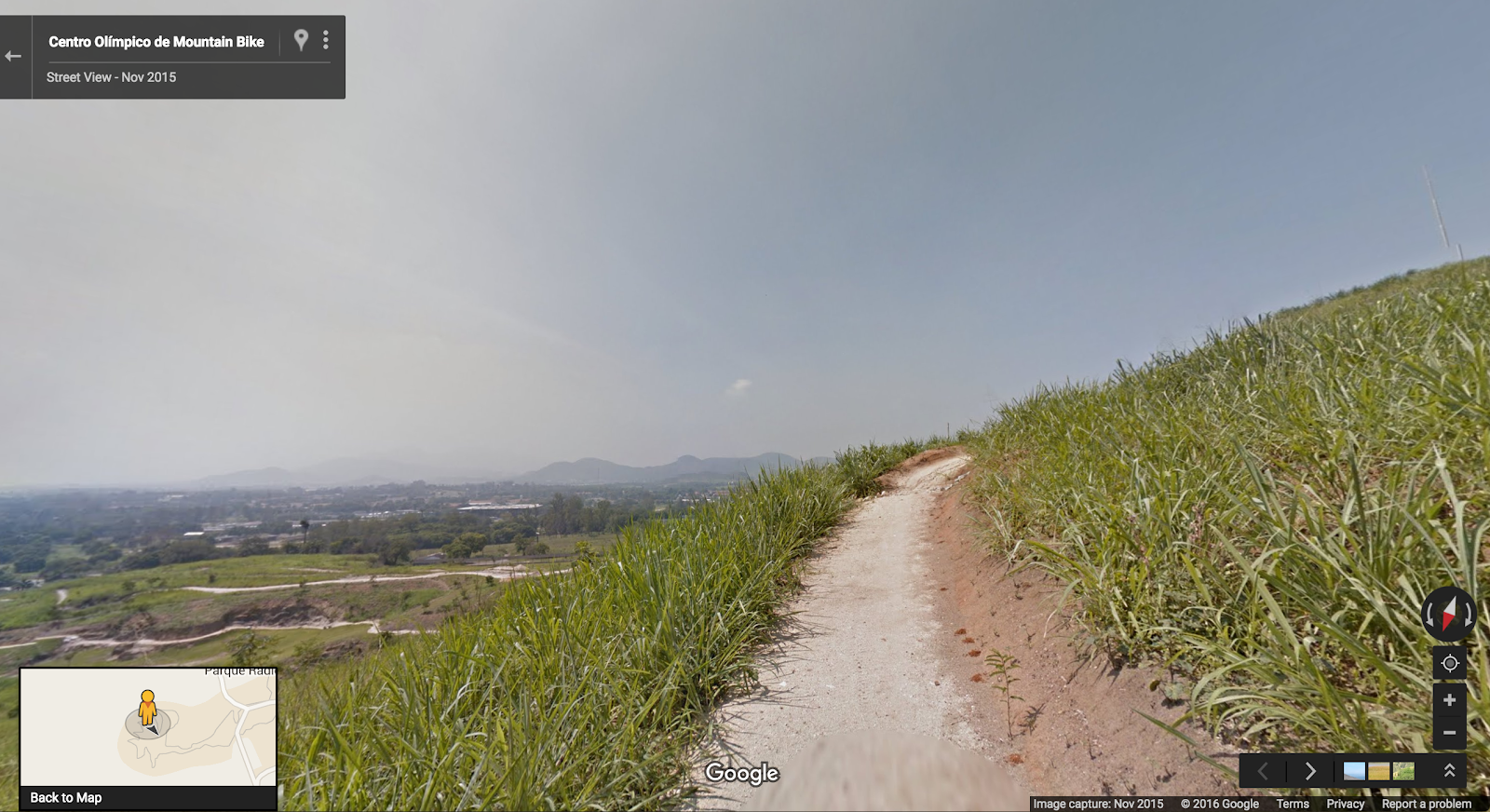
Olympic Mountain Bike Trail

We’re also releasing indoor imagery of more than 200 hotels, restaurants and bars across the city. Take a peek at the pink carpeted Copacabana Palace or the breathtaking poolside ocean views at the Fasano Hotel. If you’ll be in Rio for the Games, check out the vibe before you make restaurant reservations or the local bar to ensure there’s ample room on the dancefloor to bust out your Samba moves.


Suite in the Fasano Hotel, famous for its celebrity guests in Rio

Step outside to take in some of the most iconic sites of Rio including Christ the Redeemer, The Dona Marta Hilltop, and Arpoador Beach. We’ve captured imagery of every main tourist attraction in Rio including the famous Selarón Steps.


View from Arpoador Beach

In addition to the many beautiful sites, we’ve collected up-to-date Street View imagery of Rio's streets and neighborhoods so you can get a feel for the area around your accommodation ahead of time. Check out the bus stops to familiarize yourself with local transportation - or pick the perfect people watching Juice bar to enjoy an Acai bowl on the way from the hotel to the beach.

Whether you’re preparing to visit in person or simply enjoying the sites from afar, make yourself a caipirinha or have a Pau De Queijo (delicious Brazilian cheese bread) while you explore.

Posted by Marcus Leal, Google Maps manager in Brazil

Source: Google LatLong