Tag Archives: Maps 101

How 15 years of mapping the world makes Search better

Our Maps 101 series goes behind the scenes to share how we help you navigate, explore and get things done every single day. Over the past 15 years, we’ve provided maps in more than 220 countries and territories and now surface helpful information for more than 200 million places. These efforts bring helpful local information to your fingertips in Google Maps and produce better Google Search results, helping you connect with nearby places and businesses. 

In fact, Search results that show local places and businesses now drive more than 4 billion connections between customers and businesses every month. This includes more than 2 billion monthly website clicks and other connections, such as phone calls, directions, food ordering and reservations. 

Today, we’ll share more about the innovations and investments that help build an accurate and up-to-date understanding of places for the billions of people looking for local information on Search and Maps.

Maximizing Street View with breakthroughs in AI

Street View imagery lets you virtually explore the world, and helps us accurately reflect local information about places in Maps and Search. We’ve travelled more than 10 million miles across 87 countries to capture this imagery and bring new information online—from unmapped roads to new businesses.

Applying artificial intelligence to our more than 170 billion Street View images helps us create high-quality maps faster than we could before. For instance, applying machine learning models to Street View imagery has improved the accuracy of one-third of the addresses in Google Maps and Search, resulting in more reliable maps as people look for a local business or navigate to a destination. 

Text recognition in the natural environment is challenging—especially at scale. The average Street View photo has visual distractions like distortions, cluttered backgrounds with extraneous text and awkward viewpoints. After years of teaching machine learning models, our text recognition systems can tune out these distractions and detect business names and addresses even when they're handwritten on the side of a building or abbreviated. These models can understand a variety of languages across various scripts too, from Latin, Cyrillic and Thai to Chinese, Japanese and Korean.

In the last few years alone, processing imagery with AI has been one of the important ways we’ve been able to add more than 10 billion edits to our library of places, providing people with updated phone numbers, business hours and locations as they use Maps and Search.

Building data partnerships with authoritative sources worldwide

Thanks to partnerships covering more than 10,000 local governments, municipal agencies and organizations around the world, we're able to reflect the latest information in Search and Maps results and help local authorities reach even more people in their communities with important updates. This includes everything from bike lanes and road closures to the addresses of hospitals and food banks. Our teams vet each authoritative data source to make sure it’s accurate before it appears on Search and Maps.

Working with authorities around the world also helps us quickly gather and surface critical information. This year, these partnerships made it possible to make important updates relevant to COVID-19. When you search for “COVID test” on Search and Maps we now show you more than 17,000 COVID-19 testing centers across 20 countries and all 50 U.S. states. You can also see important details like if appointments are required, who can get tested and if there’s drive-through testing. 

These details are crucial and accuracy is key, which is why we lean on authoritative sources to help us surface this information in Maps and Search.

A global community contributes to make Search and Maps better

To ensure our products reflect the real world as fast as it changes, we enable people everywhere to contribute their local knowledge. Every day, people make millions of contributions to Google Maps, like reviews, photos, address updates and more. And we’re seeing more people contributing than ever before. In the past 3 years, the number of reviews, ratings and photos people have added to Google Maps more than doubled.

With local details from people in Maps and Search, it’s easier to make more informed decisions. You can quickly find reviews when looking for a mechanic, see photos others have added for a park you’d like to explore, and find your convenience store’s new hours. 

A phone shows what people’s reviews on Maps and Search look like

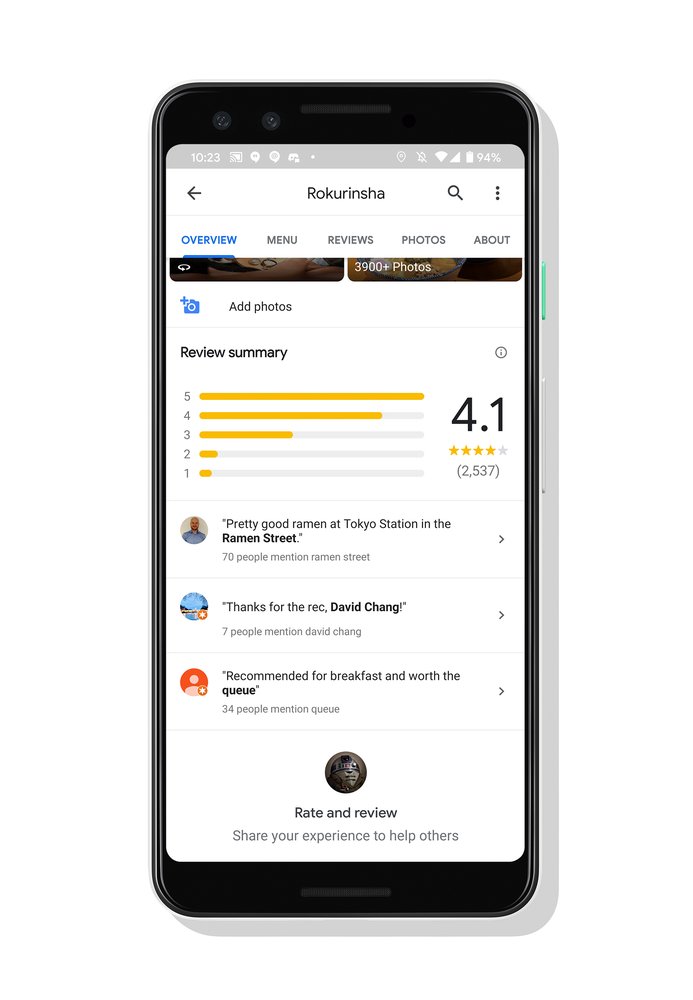
People’s reviews on Maps and Search make it easier to discover new places and learn about businesses nearby.

This year, as cities and countries instituted restrictions throughout the pandemic, many places temporarily closed or changed their operations. While businesses can indicate if they are open with their Google My Business listing, we’ve also made it easy for anyone to mark a business as open or temporarily closed on Search and Maps by simply suggesting an edit. Over the course of the pandemic, people have submitted millions of temporary closure and reopen reports, helping eliminate the uncertainty about which businesses are open and when. 

Giving business owners free tools to connect with customers online 

One of the most important ways we help local businesses succeed is by connecting them with customers online. Business owners can claim their free Business Profile and connect directly with customers across Search and Maps via phone calls, messages and reservations. They can also share accurate information about their business, including opening hours, services offered and contact information. And each month Google connects people with more than 120 million businesses that don't have websites, helping small business owners who aren’t online attract more customers.

Over the last five years, we’ve made more than a thousand improvements to Business Profiles, making it easier for merchants to connect with customers and share updates online. We recently made this even easier by adding new ways for merchants to view and update their Business Profile directly from Search and Maps. 

With the pandemic causing daily disruptions worldwide, Google has helped businesses keep customers updated about everything from new services to adjusted store capacity and hours. Since the start of COVID-19, businesses made nearly 700 million edits to their Business Profiles, about double the number of changes made during the same time last year. 

Image of desktop and phone show how it's easy for a business owner to update their Business Profile and engage with customers directly from Search and Maps.

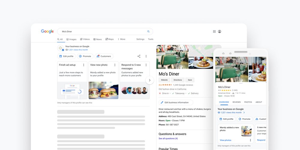
It’s easy for a business owner to update their Business Profile and engage with customers directly from Search and Maps.

Gathering local information in totally new ways

To help people find what they need in a world that changes by the minute, we’ve developed new ways to find and surface information.

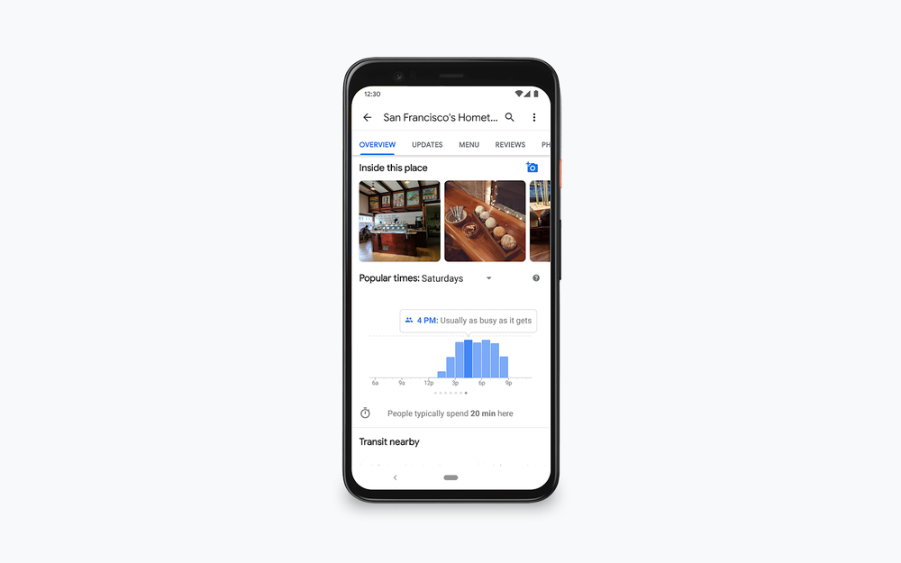
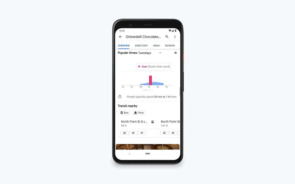
For example, people tend to avoid crowded stores and long lines—and this has been especially true during the pandemic. Popular times and live busyness information help people see how busy a place tends to be at a specific time or at that very moment. Gone are the days of guessing the best time to go grocery shopping! We’re expanding live busyness information to millions of places globally and to include essential places like gas stations, grocery stores, laundromats and pharmacies.

Google’s conversational technology, Duplex, has helped us scale our ability to confirm updated information for places. Since the beginning of the pandemic, we’ve put Duplex to work making calls to businesses in eight countries—from New Zealand to the United States—to confirm things like opening hours or whether they offer takeout and delivery. This has helped us make millions of updates to business information that have been seen more than 20 billion times in Maps and Search.

Building the most helpful map of an infinitely detailed world

Beyond the technologies we’ve developed, our global operations teams play a role in nearly every aspect of mapmaking. They gather data, train machine learning models that help us index information from imagery, fix problems and evaluate authoritative data sources. They also build and maintain the automated systems that protect people from fake contributed content and even help small business owners set up Google My Business accounts.

All this to say, our work to organize the world's information and make it accessible and useful is never done. Given the pace of change, there’s never been a more important time for us to be helpful.

Source: Google LatLong


Behind the scenes: popular times and live busyness information

If you’ve ever been in a rush to grab a quick bite, you may know the pain that comes along with finding out that the restaurant you chose is packed and there’s nowhere to sit. Or maybe you need to pick up just one item from the grocery store, only to find that the line is out the door—derailing your plans and causing you unnecessary stress. 


These problems were top of mind when Google Maps launched popular times and live busyness information—helpful features that let you see how busy a place tends to be on a given day and time or in a specific moment. This information has become a powerful tool during the pandemic, making it easier to social distance because you know in advance how crowded a place will be. Today, we’ll take a closer look at how we calculate busyness information, while keeping your data private and secure.

Popular times: making sense of historical busyness information

To calculate busyness insights, we analyze aggregated and anonymized Location History data from people who have opted to turn this setting on from their Google Account. This data is instrumental in calculating how busy a place typically is for every hour of the week. The busiest hour becomes our benchmark—and we then display busyness data for the rest of the week relative to that hour. 


For example, say there’s a new ice cream shop down the block known for its homemade waffle cones ?. With Location History insights, our systems know that the shop is consistently most crowded on Saturday afternoons at 4 p.m. As a result, popular times information for the rest of the week will be displayed as “Usually as busy as it gets” when it’s approximately as busy as Saturday at 4 p.m.,“Usually not too busy” when it is much less busy, and “Usually a little busy” for somewhere in between. This data can also show how long people tend to spend at the ice cream shop, which is handy if you’re planning a day with multiple activities and want to know how much time to allocate at each place. 


popular_times

Popular times information shows you how busy a place tends to be

Making adjustments in times of COVID

Google Maps’ popular times algorithms have long been able to identify busyness patterns for a place. With social distancing measures established and businesses adjusting hours or even closing temporarily due to COVID-19, our historical data was no longer as reliable in predicting what current conditions would be.  To make our systems more nimble, we began favoring more recent data from the previous four to six weeks to quickly adapt to changing patterns for popular times and live busyness information–with plans to bring a similar approach to other features like wait times soon.


Real-time busyness information: how busy a place is right now

Busyness patterns identified by popular times are useful—but what about when there are outliers? Shelter in place orders made local grocery stores much more busy than usual as people stocked up on supplies. Warm weather can cause crowds of people to flock to a nearby park. And a new promotion or discount can drive more customers to nearby stores and restaurants.


Take the ice cream shop again. Say that, knowing that business is slow on Tuesdays, the shop owners decide to host a three scoop sundae giveaway on a Tuesday to promote their newest flavor—because everyone loves free ice cream! The promotion brings in more than double the amount of customers they typically see on that day and time. Gleaning insights from Location History data in real time, our systems are able to detect this spike in busyness and display it as “Live” data in Google Maps so you can see how busy the shop is right now—even if it varies drastically from its typical busyness levels.


live_busyness

Live busyness information shows you how busy a place is right now

Making sure your data is private, safe and secure

Privacy is a top priority when calculating busyness, and it’s woven into every step of the process. We use an advanced statistical technique known as differential privacy to ensure that busyness data remains anonymous. Differential privacy uses a number of methods, including artificially adding “noise” to our Location History dataset to generate busyness insights without ever identifying any individual person. And if our systems don’t have enough data to provide an accurate, anonymous busyness recommendation, we don’t publish it—which is why there are times when you may not see busyness information for a place at all.


Google Maps is always thinking about ways to solve the problems you face throughout your day, whether they’re big (like getting around safely) or small (like quickly snagging your favorite scoop of ice cream). Check out the Maps 101 series for other under-the-hood looks at your favorite features, with more deep dives coming soon.

More from this Series

Maps 101

Google Maps helps you navigate, explore, and get things done every single day. In this series, we’ll take a look under the hood at how Google Maps uses technology to build helpful products—from using flocks of sheep and laser beams to gather high-definition imagery to predicting traffic jams that haven’t even happened yet.

View more from Maps 101

Source: Google LatLong


How we’re giving everyone, everywhere an address

We’ve gone behind the scenes to look at how we map the world, use imagery to capture the meaningful details around us, and all the ways contributed content and AI make Google Maps a more helpful tool—from planning your trip to deciding where to go.

Today, we’ll dive into how we are working to make sure everyone in the world has access to an address using our free, open-source digital address-making system called Plus Codes.

Addresses help us find people and places, and they help people and things find us. An address is also necessary to secure official documents and do things like open a bank account. However, several billion people either don’t have an address at all or they have one that doesn’t accurately identify the location of their home or business. Plus Codes offer a simple but powerful solution. Already, Google Maps provides millions of directions each month to people looking up a place with a Plus Code and this volume is rapidly growing.

Plus Codes help ensure that everyone, everywhere can exist on a digital map, with digital addresses, no matter where they live.

So what are Plus Codes? 

Plus Codes use latitude and longitude to produce a short, easy-to-share digital address that can represent any location on the planet. For example, the Plus Code “W2GJ+JQ, Johannesburg” represents the main entrance to the Google office in Johannesburg, South Africa. Put this code into Google Maps or Google Search and you’ll be brought right to our front door in Johannesburg.

Google's office Plus Codes address in Johannesburg

The Plus Code address for Google's Johannesburg office is W2GJ+JQ, Johannesburg

Helping people get on the map

A Plus Code can easily be used where no addresses, street names or even streets exist today.  Someone in an area without addresses no longer needs to give out complicated instructions to find a home or workplace—like “drive to the community center, turn left and look for the blue house with the red roof.”  Now, they can simply share a short Plus Code and it immediately works.

Businesses and services that rely on navigating to peoples’ homes can simply enter the Plus Code into Google Maps and get directions instantly. Emergency services and humanitarian groups can more easily find people who need aid, locate people for vaccine programs and easily track health programs all with Plus Codes. 


Generating Plus Codes

In the absence of street names and accurate addresses, how are Plus Codes created? 

First, we divide the world along latitude and longitude lines to form a simple grid. The grid is labelled along the X and Y axis using a specific set of 20 alphanumeric characters  {2,3,4,5,6,7,8,9,C,F,G,H,J,M,P,Q,R,V,W,X}. You’ll never see a vowel or characters like “1”, “L” and “l” in a Plus Code as we want to avoid confusion over the characters when writing them down and prevent any accidental word formations. And by using a carefully selected set of alphanumeric characters, Plus Codes can be used by anyone no matter what language you speak.

Each grid cell on the digital globe is then further divided, the X and Y-axes again labelled with the 20 characters above and the process repeated to build out a full Plus Code. In the case of the Google Johannesburg office this would result in a full Plus Code of “5G5CW2GJ+JQ”. 

Since a full Plus Code might not be easy to recall, you can conveniently drop the first four characters of the code if you know the area you are in,  just as we drop area codes on telephone numbers when already in the area. In this case, if I know I am in Johannesburg the Plus Code for the Google office can be shortened to “W2GJ+JQ, Johannesburg.”

Depending on the number of characters included in the code after the ‘+’ sign, the code can be even more specific. For example a Plus Code with two characters after the ‘+’ sign represents an area of approximately 13m x 13m, about the size of a half a basketball court. Adding an additional character reduces this size to approximately 3m x 3m, providing an exact address for a sidewalk vendor who may not even have a storefront. 

And this might go without saying, but Plus Codes are named after the ‘+’ sign that is one of their key characteristics. This sign is used to help people and our digital applications recognize the code as a Plus Code. 

Plus Codes in Sao Paolo, Brazil

Plus Codes in Sao Paolo, Brazil

Community addressing

Providing conventional (non-digital) addresses to communities at scale can be complicated and expensive for local and national governments, often taking years to set up and become useful. With Plus Codes, a village, town, city or even country can quickly and efficiently set up an addressing system. And unlike conventional addressing projects, once a Plus Code address is created it is immediately usable on platforms such as Google Maps and anywhere else that recognizes Plus Codes both online and offline. This means that new services (both digital and non-digital) are more readily available to traditionally underserved communities that lack proper addresses. 

The power of Plus Code addresses

While there are other digital address-making solutions, they’re often proprietary or must be commercially licensed, which can mean unnecessary costs, complications and longer term uncertainty for businesses and governments. These solutions also have challenges with universal recognition and adoption, as they are generally not open source or freely available.  

Here’s a taste of the positive impact we’ve seen Plus Codes deliver.


We recently introduced a refreshed Plus Codes icon to make it more recognizable. If you’d like to learn more about Plus Codes, how to use them and how they’re being used, visit maps.google.com/pluscodes.