Google Maps helps over one billion people navigate and explore. And over the past few years, our investments in AI have supercharged the ability to bring you the most helpful information about the real world, including when a business is open and how crowded your bus is. Today at Google I/O, we announced new ways the latest advancements in AI are transforming Google Maps — helping you explore with an all-new immersive view of the world, find the most fuel-efficient route, and use the magic of Live View in your favorite third-party apps.
A more immersive, intuitive map
Google Maps first launched to help people navigate to their destinations. Since then, it’s evolved to become much more — it’s a handy companion when you need to find the perfect restaurant or get information about a local business. Today — thanks to advances in computer vision and AI that allow us to fuse together billions of Street View and aerial images to create a rich, digital model of the world — we’re introducing a whole new way to explore with Maps. With our new immersive view, you’ll be able to experience what a neighborhood, landmark, restaurant or popular venue is like — and even feel like you’re right there before you ever set foot inside. So whether you’re traveling somewhere new or scoping out hidden local gems, immersive view will help you make the most informed decisions before you go.
Say you’re planning a trip to London and want to figure out the best sights to see and places to eat. With a quick search, you can virtually soar over Westminster to see the neighborhood and stunning architecture of places, like Big Ben, up close. With Google Maps’ helpful information layered on top, you can use the time slider to check out what the area looks like at different times of day and in various weather conditions, and see where the busy spots are. Looking for a spot for lunch? Glide down to street level to explore nearby restaurants and see helpful information, like live busyness and nearby traffic. You can even look inside them to quickly get a feel for the vibe of the place before you book your reservation.
The best part? Immersive view will work on just about any phone and device. It starts rolling out in Los Angeles, London, New York, San Francisco and Tokyo later this year with more cities coming soon.
Immersive view lets you explore and understand the vibe of a place before you go
An update on eco-friendly routing
In addition to making places easier to explore, we want to help you get there more sustainably. We recently launched eco-friendly routing in the U.S. and Canada, which lets you see and choose the most fuel-efficient route when looking for driving directions — helping you save money on gas. Since then, people have used it to travel 86 billion miles, saving more than an estimated half a million metric tons of carbon emissions — equivalent to taking 100,000 cars off the road. We’re on track to double this amount as we expand to more places, like Europe.
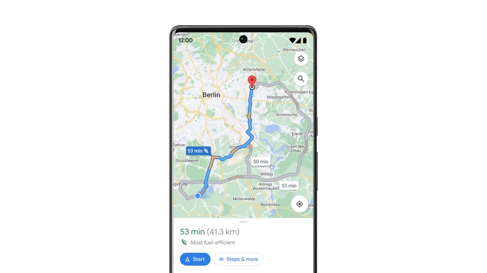
Eco-friendly routing has helped save more than an estimated half a million metric tons of carbon emissions
The magic of Live View — now in your favorite apps
Live View helps you find your way when walking around, using AR to display helpful arrows and directions right on top of your world. It's especially helpful when navigating tricky indoor areas, like airports, malls and train stations. Thanks to our AI-based technology called global localization, Google Maps can point you where you need to go in a matter of seconds. As part of our efforts to bring the helpfulness of Google Maps to more places, we’re now making this technology available to developers at no cost with the new ARCore Geospatial API.
Developers are already using the API to make apps that are even more useful and provide an easy way to interact with both the digital and physical worlds at once. Shared electric vehicle company Lime is piloting the API in London, Paris, Tel Aviv, Madrid, San Diego, and Bordeaux to help riders park their e-bikes and e-scooters responsibly and out of pedestrians’ right of way. Telstra and Accenture are using it to help sports fans and concertgoers find their seats, concession stands and restrooms at Marvel Stadium in Melbourne. DOCOMO and Curiosity are building a new game that lets you fend off virtual dragons with robot companions in front of iconic Tokyo landmarks, like the Tokyo Tower. The new Geospatial API is available now to ARCore developers, wherever Street View is available.

Live View technology is now available to ARCore developers around the world
AI will continue to play a critical role in making Google Maps the most comprehensive and helpful map possible for people everywhere.