Category Archives: Google Travel Blog

The latest news and notes from the Travel team

Navigate and search the real world … online or off

Roughly 60 percent of the world is without Internet today, and even where online access is available, it can still be spotty. That means that quick and easy access to information is still not possible for a majority of the population. This is a huge problem, especially as people attempt to navigate and explore the world around them, so Google Maps is taking steps to help people across the globe find directions and get where they’re going, even when they don’t have an Internet connection.

Now you can download an area of the world to your phone, and the next time you find there’s no connectivity—whether it’s a country road or an underground parking garage—Google Maps will continue to work seamlessly. Whereas before you could simply view an area of the map offline, now you can get turn-by-turn driving directions, search for specific destinations, and find useful information about places, like hours of operation, contact information or ratings.

product-offroad-setup-v1-r2.gif

You can download an area by searching for a city, county or country, for instance, and tapping "Download" on the resulting place sheet, or by going to "Offline Areas" in the Google Maps menu and tapping on the “+” button. Once downloaded, Google Maps will move into offline mode automatically when it recognizes you’re in a location with spotty service or no connectivity at all. When a connection is found, it will switch back online so you can easily access the full version of Maps, including live traffic conditions for your current route. By default, we’ll only download areas to your device when you are on a Wi-Fi connection to prevent large data fees.

Offline_Maps_How_it_works.gif

We first previewed these new capabilities during Google I/O in May, and today we’re gradually rolling out the first set of these improvements with the latest version of Google Maps on Android (coming soon to iOS). Over time, we’ll be introducing even more offline features to help you find your way—even when you can’t find a connection.
Source: Travel


Navigate and search the real world … online or off

Roughly 60 percent of the world is without Internet today, and even where online access is available, it can still be spotty. That means that quick and easy access to information is still not possible for a majority of the population. This is a huge problem, especially as people attempt to navigate and explore the world around them, so Google Maps is taking steps to help people across the globe find directions and get where they’re going, even when they don’t have an Internet connection.

Now you can download an area of the world to your phone, and the next time you find there’s no connectivity—whether it’s a country road or an underground parking garage—Google Maps will continue to work seamlessly. Whereas before you could simply view an area of the map offline, now you can get turn-by-turn driving directions, search for specific destinations, and find useful information about places, like hours of operation, contact information or ratings.

You can download an area by searching for a city, county or country, for instance, and tapping "Download" on the resulting place sheet, or by going to "Offline Areas" in the Google Maps menu and tapping on the “+” button. Once downloaded, Google Maps will move into offline mode automatically when it recognizes you’re in a location with spotty service or no connectivity at all. When a connection is found, it will switch back online so you can easily access the full version of Maps, including live traffic conditions for your current route. By default, we’ll only download areas to your device when you are on a Wi-Fi connection to prevent large data fees.

We first previewed these new capabilities during Google I/O in May, and today we’re gradually rolling out the first set of these improvements with the latest version of Google Maps on Android (coming soon to iOS). Over time, we’ll be introducing even more offline features to help you find your way—even when you can’t find a connection.

Source: Travel


Navigate and search the real world … online or off

Roughly 60 percent of the world is without Internet today, and even where online access is available, it can still be spotty. That means that quick and easy access to information is still not possible for a majority of the population. This is a huge problem, especially as people attempt to navigate and explore the world around them, so Google Maps is taking steps to help people across the globe find directions and get where they’re going, even when they don’t have an Internet connection.

Now you can download an area of the world to your phone, and the next time you find there’s no connectivity—whether it’s a country road or an underground parking garage—Google Maps will continue to work seamlessly. Whereas before you could simply view an area of the map offline, now you can get turn-by-turn driving directions, search for specific destinations, and find useful information about places, like hours of operation, contact information or ratings.

product-offroad-setup-v1-r2.gif

You can download an area by searching for a city, county or country, for instance, and tapping "Download" on the resulting place sheet, or by going to "Offline Areas" in the Google Maps menu and tapping on the “+” button. Once downloaded, Google Maps will move into offline mode automatically when it recognizes you’re in a location with spotty service or no connectivity at all. When a connection is found, it will switch back online so you can easily access the full version of Maps, including live traffic conditions for your current route. By default, we’ll only download areas to your device when you are on a Wi-Fi connection to prevent large data fees.

Offline_Maps_How_it_works.gif

We first previewed these new capabilities during Google I/O in May, and today we’re gradually rolling out the first set of these improvements with the latest version of Google Maps on Android (coming soon to iOS). Over time, we’ll be introducing even more offline features to help you find your way—even when you can’t find a connection.

Source: Travel


Navigate and search the real world … online or off

Roughly 60 percent of the world is without Internet today, and even where online access is available, it can still be spotty. That means that quick and easy access to information is still not possible for a majority of the population. This is a huge problem, especially as people attempt to navigate and explore the world around them, so Google Maps is taking steps to help people across the globe find directions and get where they’re going, even when they don’t have an Internet connection.

Now you can download an area of the world to your phone, and the next time you find there’s no connectivity—whether it’s a country road or an underground parking garage—Google Maps will continue to work seamlessly. Whereas before you could simply view an area of the map offline, now you can get turn-by-turn driving directions, search for specific destinations, and find useful information about places, like hours of operation, contact information or ratings.

product-offroad-setup-v1-r2.gif

You can download an area by searching for a city, county or country, for instance, and tapping "Download" on the resulting place sheet, or by going to "Offline Areas" in the Google Maps menu and tapping on the “+” button. Once downloaded, Google Maps will move into offline mode automatically when it recognizes you’re in a location with spotty service or no connectivity at all. When a connection is found, it will switch back online so you can easily access the full version of Maps, including live traffic conditions for your current route. By default, we’ll only download areas to your device when you are on a Wi-Fi connection to prevent large data fees.

Offline_Maps_How_it_works.gif

We first previewed these new capabilities during Google I/O in May, and today we’re gradually rolling out the first set of these improvements with the latest version of Google Maps on Android (coming soon to iOS). Over time, we’ll be introducing even more offline features to help you find your way—even when you can’t find a connection.

Source: Travel


Google adds trains to Google Flights in Europe

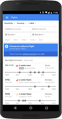
Every year, billions of people travel across Europe for personal and professional reasons — often choosing high-speed rail as a convenient option. Now Google Flights makes it easy to compare the time and cost to ride vs. fly when trains are a logical and good alternative to many flight routes in Europe.

We started by adding train options for routes in Italy and Spain. Today we’re excited to announce a partnership with Deutsche Bahn in Germany to bring their expansive, fast rail service to Google Flights.

This launch lets you use Google Flights to find train options for 56 destinations and nearly 400 routes across Germany and Northern Europe. Popular routes include domestic routes like Frankfurt-Munich and Hamburg-Stuttgart, as well as international routes like Zurich-Frankfurt and Frankfurt-Amsterdam.

"The Google Flights partnership specifically helps us reach international travelers. For many German and European routes, trains are an attractive alternative to flights. Deutsche Bahn´s integration into Google Flights is another step in our partnership with Google already providing train routes and itineraries for Google Maps,” said Mathias Hüske, Head of eCommerce at DB Vertrieb GmbH - Deutsche Bahn AG.

Google Flights also makes it easier to sift through long lists of similar trains. In the same way we group similar flights, trains are grouped together — with departure times displayed across a one-day timeline.

“On many routes the convenience of a train connection from city center to city center can offset travel times to and from the airport. We’re excited to bring European travelers even more options with expansive trains data from Deutsche Bahn,” said Noam Ben-Haim, Senior Product Manager, Travel.

Whether you’re shopping on a mobile device or desktop, Google Flights makes it easy to scan available trains and flights — to quickly determine which is best for you. Give it a try on your next European trip.

Source: Google Travel


Tell us what you think about the Google Travel Blog

Hello friends, partners and travel enthusiasts. We know it’s been awhile since our last post. The team has been focused on making the next set of features and travel products that will make your traveling life easier — and we’ve been doing our best to get the word out about all this hard work.

Now we want to hear from you. We’re asking you to answer this super short survey. Tell us what you like and what you would like to see more of on our Google Travel Blog.

If you don’t already do so, you can also follow us on our Google Travel Google+ page and Twitter.

Source: Google Travel


Vertical Street View of the world’s most iconic rock wall: Yosemite’s El Capitan

Today we’re launching our first-ever vertical Street View collection, giving you the opportunity to climb 3,000 feet up the world’s most famous rock wall: Yosemite’s El Capitan. To bring you this new imagery, we partnered with legendary climbers Lynn Hill, Alex Honnold and Tommy Caldwell. Read more about the project from Tommy Caldwell, who completed the world’s hardest climb in Yosemite in January of 2015. -Ed.

“That is awesome. I definitely have to be a part of that.”

Maybe it was the sheer exhaustion from being in the middle of a 19-day climb of the Dawn Wall, but when the guys at Google Maps and Yosemite National Park asked if I wanted to help them with their first-ever vertical Street View collection of El Capitan in Yosemite, I didn’t hesitate. Yosemite has been such an important part of my life that telling the story of El Capitan through Street View was right up my alley—especially when it meant working with the Google engineers to figure out some absurd challenges.

Scale Yosemite's El Capitan in Google Maps with Alex Honnold, Lynn Hill, and Tommy Caldwell

Scale Yosemite's El Capitan in Google Maps

Climbing is all about flirting with the impossible and pushing the boundaries of what you think you can be done. Capturing Street View imagery 3,000 feet up El Capitan proved to be an extension of that, especially when you take a camera meant for the inside of a restaurant and mount it thousands of feet up the world’s most iconic rock wall.

Alex-King-swing.width-1600-1.jpg
Brett Lowell and Corey Rich capturing Street View of Alex Honnold on the King Swing

Doing anything thousands of feet high on a sheer granite face is complicated, but everyone up there had spent years of their lives on a rope and knew exactly what they were doing. After some testing, we used our tried-and-true climbing gear like cams and ropes to make sure the camera wouldn’t fall to the ground in the middle of our Street View collection.

Once we figured out how to keep the camera on El Cap, we created two sets of vertical Street View. First, we collected Street View of legendary Yosemite climbers—and my good friends—Lynn Hill and Alex Honnold in iconic spots up the sheer vertical face.

Lynn Hill’s ascent of El Capitan changed the paradigm of climbing, and she had an extraordinary effect on my climbing career. I’ll never forget when she became the first person, man or woman, to free-climb (using only her hands and feet) “The Nose” back in 1993. Now, you can see her navigate these epic moves— like climbing sideways on tiny holds of the Jardine Traverse, inventing a “Houdini” maneuver on the Changing Corners and traversing under the Great Roof.

Any story of El Capitan had to include my good friend Alex Honnold. He holds the speed record for climbing the Nose at 2 hours and 23 minutes - most people take 3-5 days. His unwavering confidence in himself is contagious; when I’m with him, I feel like the mountain has shrunk to half its size. As you make your way around Yosemite in Street View, you’ll see Alex doing what he does best: chimneying up the “Texas Flake,” racing up the bolt ladder, or getting dinner ready in the solar-powered van he calls home.

You’ll also see a glimpse of yours truly on the Dawn Wall. I spent some of my rest days during my January climb of the Dawn Wall testing out the Street View technology the Google team had sent me that month. El Cap is an intimidating environment for experimentation, but years of setting ropes proved pretty helpful in figuring out how to get the equipment rigged and ready to collect Street View.

Then, we really put Alex to work to collect the second set of Street View: the entire vertical route of “The Nose” on El Capitan. One of the few people that could do this efficiently and quickly, Alex took the camera and pretty much ran 3,000 feet up with photographer partner Brett Lowell. Now, anyone can get the beta (climbing speak for insider advice) before they climb the entire route.

Lynn, Alex and I also helped create a new Yosemite Treks page, where you can take a tour up El Cap and learn more about climbing, from what a “hand jam” is to why we wear such tiny shoes. And as a father, I’m excited kids will learn more about Yosemite when Google brings students to the park through NatureBridge later this year as a part of this project. Plus, its pretty awesome that students who can’t make it to Yosemite yet will be able to go on a virtual reality field trip to the Park with Google Expeditions.

Yosemite’s driven so much of my life that I’m excited to be able to share it with the world through my eyes. These 360-degree panoramic images are the closest thing I’ve ever witnessed to actually being thousands of feet up a vertical rock face—better than any video or photo. But my hope is that this new imagery will inspire you to get out there and see Yosemite for yourself… whether you travel up a rock wall or just down the trail.

Source: Travel


Vertical Street View of the world’s most iconic rock wall: Yosemite’s El Capitan

Today we’re launching our first-ever vertical Street View collection, giving you the opportunity to climb 3,000 feet up the world’s most famous rock wall: Yosemite’s El Capitan. To bring you this new imagery, we partnered with legendary climbers Lynn Hill, Alex Honnold and Tommy Caldwell. Read more about the project from Tommy Caldwell, who completed the world’s hardest climb in Yosemite in January of 2015. -Ed.

“That is awesome. I definitely have to be a part of that.”

Maybe it was the sheer exhaustion from being in the middle of a 19-day climb of the Dawn Wall, but when the guys at Google Maps and Yosemite National Park asked if I wanted to help them with their first-ever vertical Street View collection of El Capitan in Yosemite, I didn’t hesitate. Yosemite has been such an important part of my life that telling the story of El Capitan through Street View was right up my alley—especially when it meant working with the Google engineers to figure out some absurd challenges.

Scale Yosemite's El Capitan in Google Maps with Alex Honnold, Lynn Hill, and Tommy Caldwell

Scale Yosemite's El Capitan in Google Maps

Climbing is all about flirting with the impossible and pushing the boundaries of what you think you can be done. Capturing Street View imagery 3,000 feet up El Capitan proved to be an extension of that, especially when you take a camera meant for the inside of a restaurant and mount it thousands of feet up the world’s most iconic rock wall.

Doing anything thousands of feet high on a sheer granite face is complicated, but everyone up there had spent years of their lives on a rope and knew exactly what they were doing. After some testing, we used our tried-and-true climbing gear like cams and ropes to make sure the camera wouldn’t fall to the ground in the middle of our Street View collection.

Once we figured out how to keep the camera on El Cap, we created two sets of vertical Street View. First, we collected Street View of legendary Yosemite climbers—and my good friends—Lynn Hill and Alex Honnold in iconic spots up the sheer vertical face.

Lynn Hill’s ascent of El Capitan changed the paradigm of climbing, and she had an extraordinary effect on my climbing career. I’ll never forget when she became the first person, man or woman, to free-climb (using only her hands and feet) “The Nose” back in 1993. Now, you can see her navigate these epic moves— like climbing sideways on tiny holds of the Jardine Traverse, inventing a “Houdini” maneuver on the Changing Corners and traversing under the Great Roof.

Any story of El Capitan had to include my good friend Alex Honnold. He holds the speed record for climbing the Nose at 2 hours and 23 minutes - most people take 3-5 days. His unwavering confidence in himself is contagious; when I’m with him, I feel like the mountain has shrunk to half its size. As you make your way around Yosemite in Street View, you’ll see Alex doing what he does best: chimneying up the “Texas Flake,” racing up the bolt ladder, or getting dinner ready in the solar-powered van he calls home.

You’ll also see a glimpse of yours truly on the Dawn Wall. I spent some of my rest days during my January climb of the Dawn Wall testing out the Street View technology the Google team had sent me that month. El Cap is an intimidating environment for experimentation, but years of setting ropes proved pretty helpful in figuring out how to get the equipment rigged and ready to collect Street View.

Then, we really put Alex to work to collect the second set of Street View: the entire vertical route of “The Nose” on El Capitan. One of the few people that could do this efficiently and quickly, Alex took the camera and pretty much ran 3,000 feet up with photographer partner Brett Lowell. Now, anyone can get the beta (climbing speak for insider advice) before they climb the entire route.

Lynn, Alex and I also helped create a new Yosemite Treks page, where you can take a tour up El Cap and learn more about climbing, from what a “hand jam” is to why we wear such tiny shoes. And as a father, I’m excited kids will learn more about Yosemite when Google brings students to the park through NatureBridge later this year as a part of this project. Plus, its pretty awesome that students who can’t make it to Yosemite yet will be able to go on a virtual reality field trip to the Park with Google Expeditions.

Yosemite’s driven so much of my life that I’m excited to be able to share it with the world through my eyes. These 360-degree panoramic images are the closest thing I’ve ever witnessed to actually being thousands of feet up a vertical rock face—better than any video or photo. But my hope is that this new imagery will inspire you to get out there and see Yosemite for yourself… whether you travel up a rock wall or just down the trail.

Source: Travel