Author Archives: Nicole Lombardo

Reducing city transport emissions with Maps and AI

City transportation is crucial to connecting residents to education, employment and essential services. At the same time, the transportation sector is where global greenhouse gas (GHG) emissions are rising the quickest.

In 2018, we launched the Environmental Insights Explorer (EIE) in collaboration with the Global Covenant of Mayors for Climate & Energy (GCoM). As part of Google's most ambitious decade of climate action, we’ve committed to helping more than 500 cities and local governments reduce an aggregate of 1 gigaton of carbon emissions per year by 2030 and beyond. With EIE, cities have free access to Google’s unique mapping data and insights so they can make sustainable decisions regarding cleaner transport policies and infrastructure programs. Since launching EIE, we’ve seen more cities and governments set ambitious climate targets. This week, 120 world governments will gather in Glasgow at COP26 to report their progress toward these commitments and set a path forward to address climate change. EIE can help cities and governments translate these targets into concrete action.

In pursuit of helping more cities take action against climate change, we will make transportation insights available in EIE for over 20,000 cities and regional governments by the end of the year, making it one of the largest ever collections of high-quality, globally consistent environmental data sources. This expansion will double the number of geographies represented in EIE, accounting for the majority of the world’s transport emissions.

As the window continues to narrow on implementing policies and plans to reduce emissions, we’re unifying around a single mission: to foster sustainability at scale. To help, we’re partnering with the C40 Cities Climate Leadership Group, a network of megacities committed to addressing climate change. Our work with C40 will help us better support the needs of cities while making data accessible to city projects that are working on climate solutions. Together we can provide higher-quality transportation activity data to measure and track GHG emissions at a global scale, while also giving state and local governments resources to better understand what’s working at a local level.

The need for action is now, and we need to rise to the challenge quickly. Google technology is unlocking our ability to generate climate-related insights and impact at a global scale. Here are a few of the latest ways we're using AI and Google Maps data in EIE.

Taking inventory of yearly progress

More cities, states and regions are committing to comprehensive climate plans to decarbonize transportation by 2040. These next two decades of ambitious action will require regular progress reports to assess what is and isn’t working.

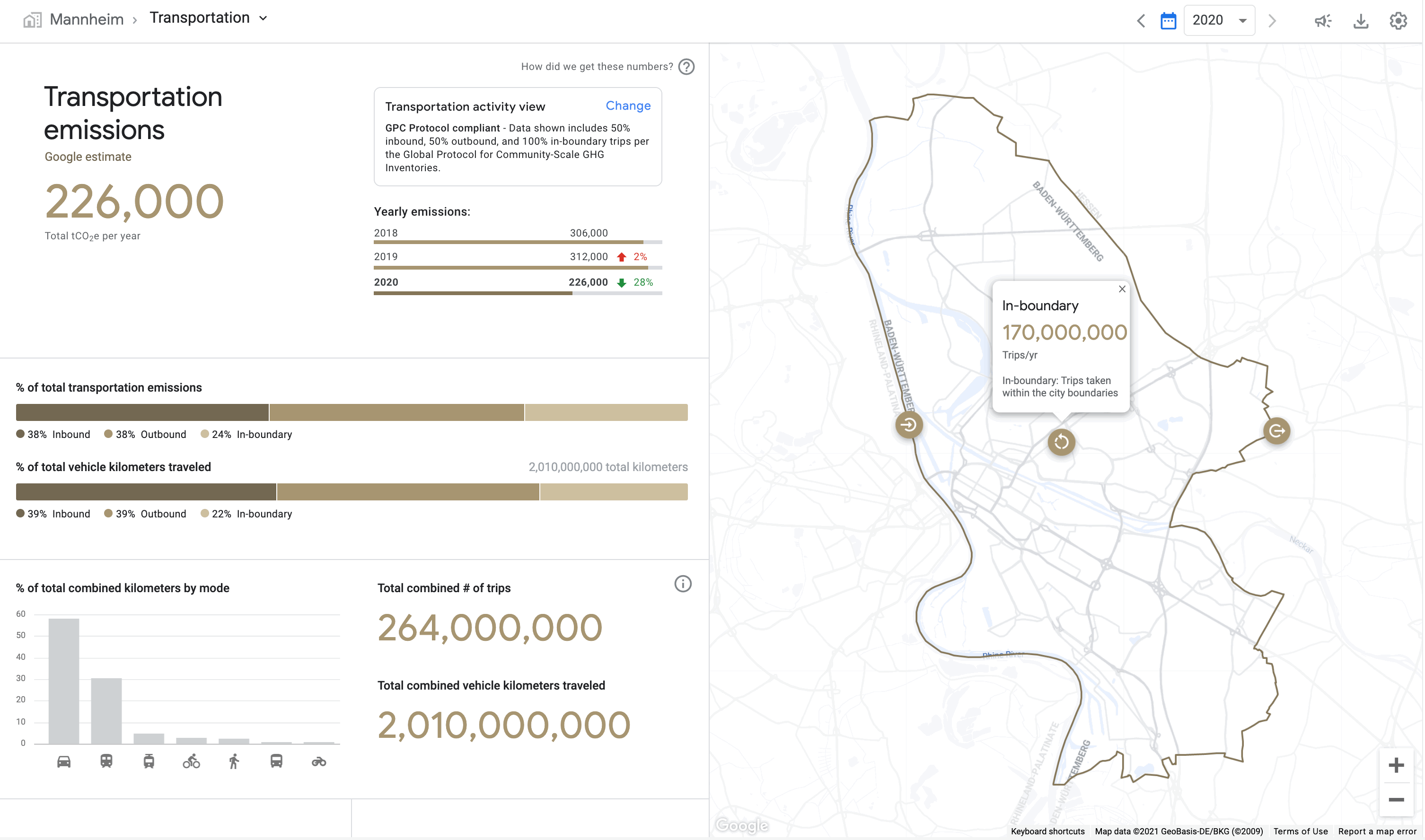
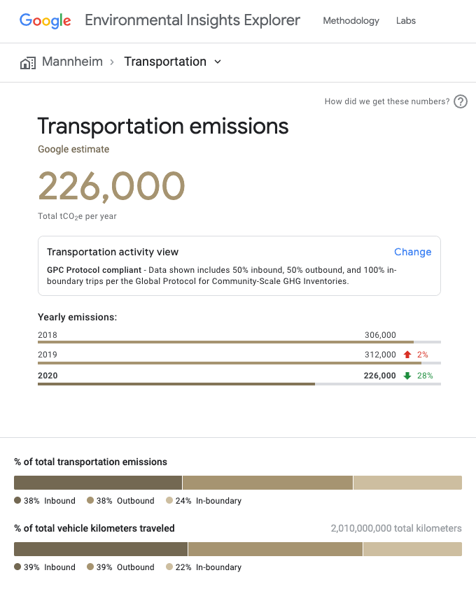
Using AI, our systems analyze transportation trends in a city by mode, helping local governments take stock of their progress in tackling GHG emissions. GHG inventory processes traditionally take months and multiple data sources to compile, and are now streamlined, allowing government staff to reduce the cost and personnel burden of reporting.

Transportation emissions estimates from Google’s Environmental Insights Explorer

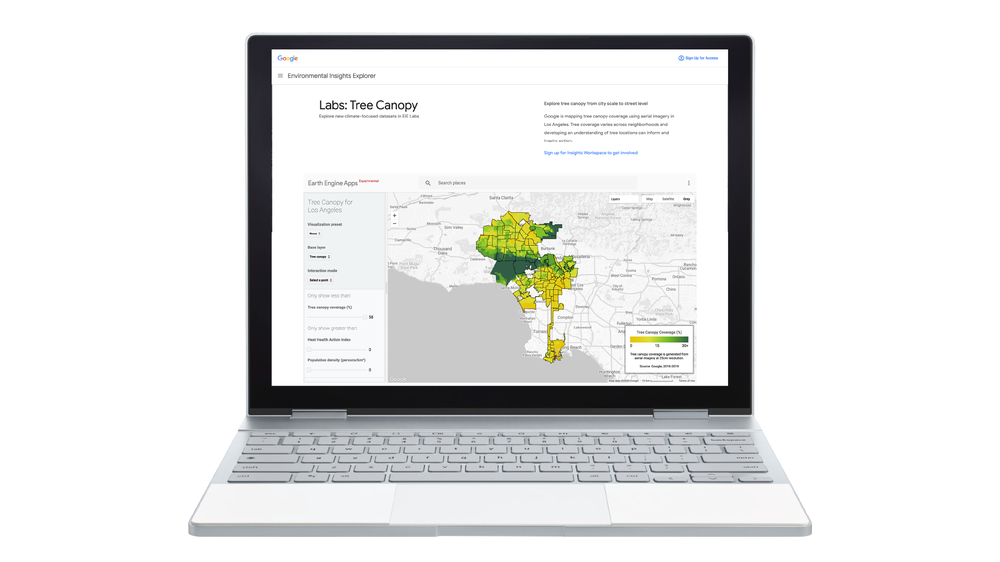
Plan eco-friendly mobility interventions

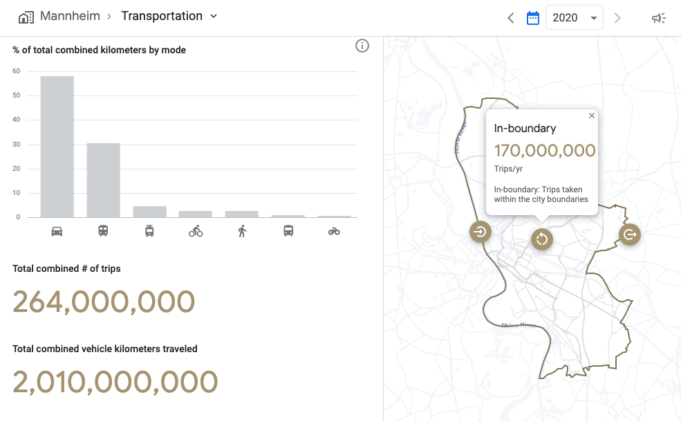
To accelerate data-driven decisions aimed at reducing transportation emissions and boosting infrastructure investments, EIE summarizes critical insights across which modes of transport to tackle. EIE characterizes trips traveled within and across city boundaries and applies city-specific scaling factors based on overall population. EIE’s multimodal insights allow government data practitioners to ask questions that inform transportation decisions, such as the extent to which city investments in different modes of transportation can shift behaviors.

Multimodal transportation emissions insights from Google’s Environmental Insights Explorer

Looking forward

Modeling transportation flows is complex. With EIE, cities, states, regional policymakers, consultants can better understand the impact sustainable changes are making on global greenhouse gas emissions.

To learn more about how cities are using EIE, view our EIE 2021 City Impact report. If you’re part of a local government and interested in what EIE can do for your community, fill out this form to get in touch with our team.

Creating new tree shade with the power of AI and aerial imagery

Most of us have heard the timeless proverb, "The best time to plant a tree was 20 years ago. The second best time is now.” Worldwide, there is growing discussion in cities about planting more trees as policymakers and neighbors look to increase shade on warming city streets.

Extreme temperatures are becoming more common in cities where concrete and infrastructure are now creating heat islands—areas that experience higher temperatures, leading to poor air quality, dehydration and other public health concerns. Trees are increasingly seen as a solution to both lowering street-level temperatures while improving quality of life. Yet many cities may not have the budget or resources to locate where every tree in town is, or where new tree-planting efforts are most needed.

With our new Tree Canopy Lab we are combining AI and aerial imagery to help cities see their current tree canopy coverage and plan future tree planting projects, starting with the City of Los Angeles. 

With the Tree Canopy Lab you can see Los Angeles’s trees with local context, like what percentage of a neighborhood has leafy cover, an area’s population density, what areas are vulnerable to extreme heat, and which neighborhood councils can help get new roots in the ground.

Tree Canopy lab is in our Environmental Insights Explorer platform, a tool that makes it easier for cities to measure, plan and reduce carbon emissions and pollution. It’s also one step forward in part our commitment to help hundreds of local governments fight climate change.


Tree Canopy Lab on a desktop device

Anyone can access the Tree Canopy Lab from a tablet or personal computer

Mapping tree cover to seed new urban forestry efforts

With aerial imagery collected from planes during the spring, summer and fall seasons, as well as Google AI and Google Earth Engine’s data analysis capabilities, we can now pinpoint all the trees in a city and measure their density. The imagery we use for these calculations includes color photos that closely represent how we would see a city from the sky. To get even more detailed information about the city’s canopy cover, near-infrared photos detect colors and details that human eyes can’t see and compare images from different angles to create a height map.

See tree cover in Los Angeles with Tree Canopy Lab

See tree cover in Los Angeles with Tree Canopy Lab

We then use a specialized tree-detection AI that automatically scans the images, detects the presence of trees and then produces a map that shows the density of tree cover, also known as “tree canopy.” 

With this tool, the City of Los Angeles doesn’t have to rely on expensive and time-intensive manual tree studies which can involve block-by-block tree surveys, outdated records, or incomplete studies which only count trees in public spaces.

From policymakers to neighbors, anyone can explore Los Angeles in the Tree Canopy Lab and glean insights. For example, the lab can help anyone identify residential blocks with high tree planting potential and locate sidewalks that are vulnerable to higher temperatures due to low canopy coverage.

Tree Canopy Lab's AI scans aerial images, detects the presence of trees and then produces a map that shows the density of tree cover

Tree Canopy Lab's AI scans aerial images, detects the presence of trees and then produces a map that shows the density of tree cover

With Tree Canopy Lab we’ve found that more than 50 percent of Angelenos live in areas with less than 10 percent tree canopy coverage and 44 percent of Angelenos live in areas with extreme heat risk. We also see a correlation that shows parts of Los Angeles with the lowest heat risk also have the highest tree canopy coverage — these areas are also the lowest population density of Angelenos.


Connecting cities with new environmental insights

Los Angeles has been on the forefront of cities using urban forestry to not only advance sustainability goals, but to beautify neighborhoods, improve air quality and bring down street-level temperatures as the region gets hotter due to climate change.

With a near-term goal of planting and maintaining 90,000 trees by 2021 and continuing to plant trees at a rate of 20,000 per year across a city of more than 503 square miles, the Tree Canopy Lab is already helping people across the city reach this goal. From neighbors and community organizations to Mayor Eric Garcetti and the city’s first-ever forestry officer, Rachel Malarich, they all have access to a birds-eye view of where the city’s existing trees are and which areas need more greenery. 


“Every tree we plant can help stem the tide of the climate crisis, and when we expand our urban forest, we can sow the seeds of a healthier, more sustainable and equitable future for communities hit hardest by rising temperatures and intensifying heat waves. Google’s technology will help us bring the power of trees to families and households across Los Angeles -- adding greenery to our public spaces, injecting beauty into our city, and bringing cooler temperatures to our neighborhoods.” 

-Mayor of Los Angeles, Eric Garcetti


More tree insights for more cities on the horizon

We’ll be making the insights in Tree Canopy Lab available to hundreds of more cities in the year to come as we continue to support the ambitious work cities like Los Angeles are doing to embark on tree planting and maintenance initiatives. 


We invite city planners and policymakers to reach out to kickstart a conversation with us sharing their interest through this form.

Source: Google LatLong