For several years, the Google Flood Forecasting Initiative has been working with governments to develop systems that predict when and where flooding will occur—and keep people safe and informed.
Much of this work is centered on India, where floods are a serious risk for hundreds of millions of people. Today, we’re providing an update on how we’re expanding and improving these efforts, as well as a new partnership we’ve formed with the International Federation of the Red Cross and Red Crescent Societies.
Expanding our forecasting reach
In recent months, we’ve been expanding our forecasting models and services in partnership with the Indian Central Water Commission. In June, just in time for the monsoon season, we reached an important milestone: our systems now extend to the whole of India, with Google technology being used to improve the targeting of every alert the government sends. This means we can help better protect more than 200 million people across more than 250,000 square kilometers—more than 20 times our coverage last year. To date, we’ve sent out around 30 million notifications to people in flood-affected areas.
In addition to expanding in India, we’ve partnered with the Bangladesh Water Development Board to bring our warnings and services to Bangladesh, which experiences more flooding than any other country in the world. We currently cover more than 40 million people in Bangladesh, and we’re working to extend this to the whole country.

Coverage areas of our current operational flood forecasting systems. In these areas we use our models to help government alerts reach the right people. In some areas we have also increased lead time and spatial accuracy.
Better protection for vulnerable communities
In collaboration with Yale, we’ve been visiting flood-affected areas and doing research to better understand what information people need, how they use it to protect themselves, and what we can do to make that information more accessible. One survey we conducted found that 65 percent of people who receive flood warnings before the flooding begins take action to protect themselves or their assets (such as evacuating or moving their belongings). But we’ve also found there’s a lot more we could be doing to help—including getting alerts to people faster, and providing additional information about the severity of floods.

Checking how our flood warnings match conditions on the ground. This photo was taken during a field survey in Bihar during monsoon 2019.
This year, we’ve launched a new forecasting model that will allow us to double the lead time of many of our alerts—providing more notice to governments and giving tens of millions of people an extra day or so to prepare.
We’re providing people with information about flood depth: when and how much flood waters are likely to rise. And in areas where we can produce depth maps throughout the floodplain, we’re sharing information about depth in the user’s village or area.
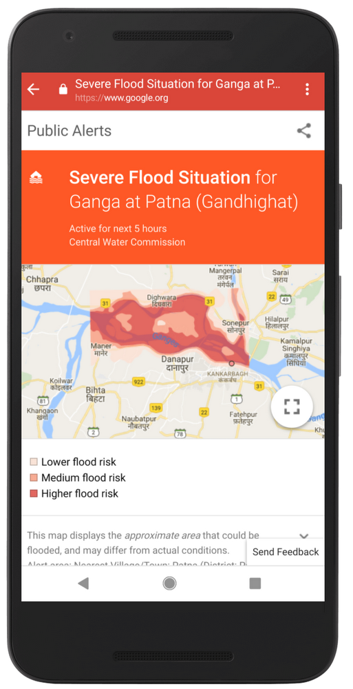
We’ve also overhauled the way our alerts look and function to make sure they’re useful and accessible for everyone. We now provide the information in different formats, so that people can both read their alerts and see them presented visually; we’ve added support for Hindi, Bengali and seven other local languages; we’ve made the alert more localized and accurate; and we now allow for easy changes to language or location.

Alerts for flood forecasting
Partnering for greater impact In addition to improving our alerts, Google.org has started a collaboration with the International Federation of Red Cross and Red Crescent Societies. This partnership aims to build local networks that can get disaster alert information to people who wouldn’t otherwise receive smartphone alerts directly.
Of course, for all the progress we’ve made with alert technology, there are still a lot of challenges to overcome. With the flood season still in full swing in India and Bangladesh, COVID-19 has delayed critical infrastructure work, added to the immense pressure on first responders and medical authorities, and disrupted the in-person networks that many people still rely on for advance notice when a flood is on the way.
There’s much more work ahead to strengthen the systems that so many vulnerable people rely on—and expand them to reach more people in flood-affected areas. Along with our partners around the world, we will continue developing, maintaining and improving technologies and digital tools to help protect communities and save lives.
Posted by Yossi Matias, VP Engineering & Crisis Response Lead