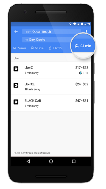
Navigating within major cities is never easy—it can take precious minutes to figure out whether it’s faster to hop on a bus, walk a few blocks, find a ride-sharing service, or hail a taxi. Starting today, it’s easier. When you search for directions using Google Maps on your mobile device, we’ll show you a dedicated tab with information for ride services—in addition to the existing car, transit, walking, or biking options you’re familiar with. So when you’re leaving work to meet a friend for dinner, you can easily compare your options to find the fastest way there, without having to open multiple apps.
In addition to our existing global ride service partner Uber, with this update we're adding new providers across five countries: 99Taxis in Brazil, Ola Cabs in India, Hailo in the UK and Spain, mytaxi in Germany and Spain, and Gett in the UK.
If you have a provider’s app installed and tap on the ride service tab, you’ll be able to see fare estimates and pick up times if a car is available near you. Select a service, and we’ll take you directly to their app for you to book your ride with one tap. When it makes sense, we’ll also show ride service availability when viewing the map in walking and transit directions, and multiple ride services options for each provider—where they exist. For example, if you’re using Uber, starting today, we’ll now show uberX, uberXL and UberBLACK for an easy and quick comparison.
Over the next few days, we’ll begin rolling out the new ride services tab on Android, and it will be coming very soon to iOS. So next time you’re looking to move around a city, open Google Maps on your phone to figure out your fastest mode of transport to get where you’re headed.
Sitting at the southernmost tip of Africa, nestled between the great Indian and Atlantic Oceans ... to many, South Africa feels a world away for both Africans and international travellers. From today, you don’t need to let hours of plane travel or miles of ocean stand in the way of the “Mzansi experience:” a virtual trip to South Africa awaits you in Google Maps.
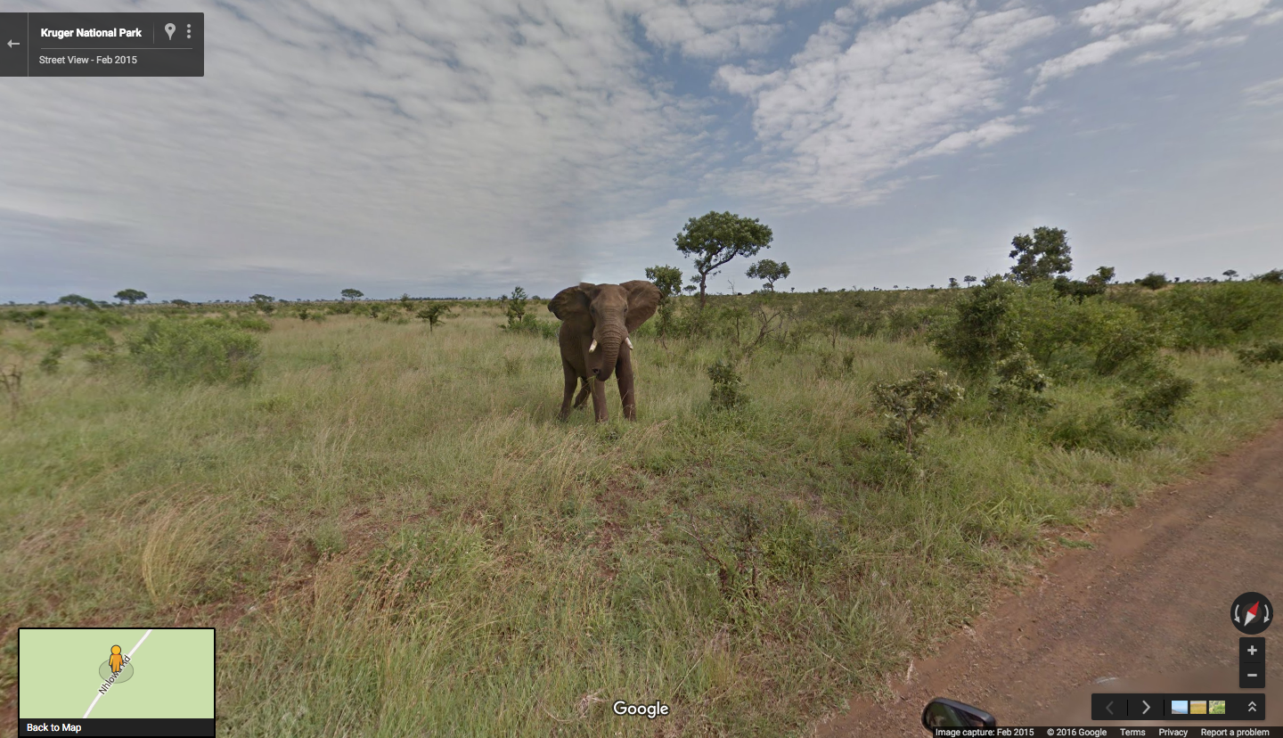
South Africa is known for its unique array of wildlife. Visiting Kruger National Park in Google Maps, you can see some of its majestic creatures as if you were there in real life. Catch a glimpse of a rhinoceros grazing the plains, an elephant enjoying a grassy snack, and a herd of buffalo charging against the wind. You may even spot a leopard, who often remain elusive to tourists and locals alike.
Climbing atop Table Mountain, even on a cloudy day, gives you a breathtaking view of where civilization and nature collide in Cape Town. Feeling like you’re on top of the world has never been so easy as it is at Jonkershoek Nature Reserve in the Western Cape.
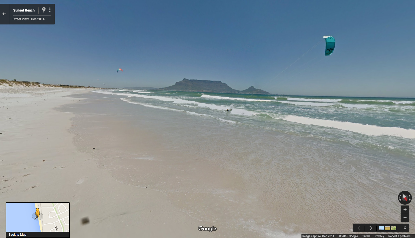
For the beach bums out there, South Africa is a must. With Street View, you can watch the waves break at Sandy Bay, gaze at the clear blue sky and water at Clifton Beach, go parasailing at Sunset Beach or just take a long walk along Durban’s Golden Mile.
This South African Street View tour is just a taste of these vast plains. We hope that visiting South Africa with Google Maps (available on iOS and Android) will inspire a deeper appreciation for the country, its wildlife and show the beauty of the African continent. Whether you continue your journey in Google Maps or in person, we invite you to enjoy the views and landscapes of the Rainbow Nation.
Posted by Sven Tresp, Street View Special Collections Program Manager
This week marks the fifth anniversary of the Great East Japan earthquake and tsunami. The most powerful quake recorded in Japan’s history, it devastated coastal areas across northeastern parts of the country. For the last five years, Google Maps has been capturing 360-degree, panoramic imagery of these areas with Street View cameras, as well as aerial photographs. These snapshots show what has changed in the aftermath of the disaster—and what hasn’t.
You can now see updated Street View imagery from 59 cities, 19 towns and 4 villages from the Ibaraki, Iwate, Fukushima and Miyagi prefectures, which was collected between June 2015 and January 2016. Part of the “Great East Japan Earthquake Digital Archive Project," this is the third Street View imagery update since the disaster.
By using Street View technology to record, exhibit and archive the damage, we hope to give people—both those who used to live there, and those who have never been—a way to see and understand the destruction caused by the earthquake and tsunami. It may also give future generations a vivid way to understand and remember what happened.
One of the areas most affected by the disaster was Fukushima prefecture. Naraha in Fukushima was an evacuation zone until September of last year, but is now being rebuilt and repopulated. The people of Naraha wanted to capture this rebuilding process, so they borrowed the Street View Trekker as part of the Trekker loan program so they could show the world what Naraha looks like today and share their hopes for the future.
In addition to the updated Street View imagery, we also have satellite and aerial imagery of the coast stretching from Hachinohe to Iwaki from before and after the disaster. As this timelapse with scenes from the Iwate, Miyagi and Fukushima prefectures shows, the road to recovery is a long one.
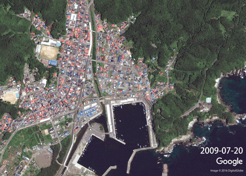
Miyako was one of the areas most devastated by the tsunami, with waters reaching at least 37.9 meters above sea level. As this timelapse shows, the seaside town was filled with homes and businesses before the earthquake struck in 2011. Everything—including parts of the mountain in the top right of the picture—was swept away by the tsunami. Clearing the rubble from the disaster took years; today, most of the new houses are being built on top of the mountain, not by the sea, in case of a future tsunami.
View of Miyako from 2009 to 2016
You can see all this imagery, as well as Street View images of these areas from before the disaster on the Google Maps "Memories for the Future" page.
Posted by Wakaba Ohkura, Google Street View Program Manager
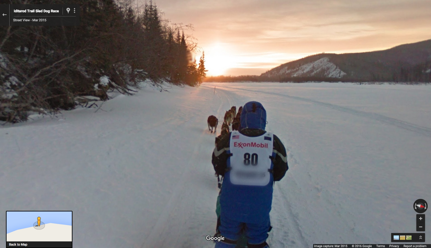
Every March, dozens of competitors and hundreds of dogs gather in Anchorage, Alaska for the start of a dog sled race that travels more than 1,000 miles to the west coast city of Nome. The Iditarod Trail Sled Dog Race requires the sled drivers or “mushers” to safely guide their dogs across the wilderness of Alaska through steep mountainous terrain, extremes of weather, and days of sleep deprivation. A British reporter covering the 1978 Iditarod tagged it “The Last Great Race on Earth.”
The Iditarod Trail is a National Historic trail that evolved as busy winter highway as people flocked to Alaska during the gold rush of the 1890s and 1900s. During the months that ocean access to western communities was frozen, dog sleds delivered groceries, mail, and even the preacher. On their return trip, they hauled gold and furs all the way to Anchorage or Fairbanks. On some days more than a hundred sleds headed over the Alaska Range, traveling 50 or more miles a day. Like the stagecoaches of the Old West, the mushers would stop at roadhouses along the route to rest and feed the dogs, and themselves.
Despite the long history of mushing in Alaska, the development of snow machines in the 1960s removed its role as a major mode of transportation, and it became primarily a recreational activity. The Iditarod Race evolved as a way to save both sled dog culture and the heritage of the Iditarod Trail. Competitors and their dog sled teams travel from checkpoint to checkpoint, just like the freight sleds did in years past. And just like those times, it’s not always an easy ride—the terrain and variable weather conditions present real challenges for the mushers, which the Google Trekker camera discovered for itself during the 2015 Iditarod.
The Google Street View Trekker wanders free near the Galena checkpoint on the Iditarod Trail
Due to unseasonably warm weather conditions over Anchorage and the Alaska Range, the route of the 2015 race was switched to begin in Fairbanks, Alaska. At the traditional “ceremonial start” (held in Anchorage), a special sled #80 driven by Dean Osmar, the 1984 Iditarod Champion, towed a second sled with a Googler wearing the trekker. The slushy conditions led to an 11-mile adventure complete with frozen puddles, cheering spectators, crashes, pink flamingos and a man-sized penguin. Sometimes our mission to map the whole world is harder than it looks!
Learning from this experience, we later successfully navigated the first 60-mile leg of the official 2015 route. Now you can follow our mushing adventures in Anchorage and Fairbanks, explore the rural Alaska communities of Galena, Unalakleet and Nome, and see the race checkpoints and finish line—all in Google Street View. This cold-weather adventure is literally at your fingertips directly from your mobile device when you download the Google Map for Mobile app on iOS and Android. And if you’re in the area in person, you can also explore and navigate to other popular spots across Anchorage and Fairbanks. Hike!
Posted by John Bailey, Program Manager for Google Geo Education
Life is full of the unexpected—things that send us scrambling for a gas station in the middle of nowhere, looking up a florist on our way home from work or searching for a restaurant as we tour the back roads of our latest vacation destination. Finding and navigating to these last-minute pit stops used to force you out of navigation mode in Google Maps—and away from the traffic updates, turn-by-turn directions and map you rely on to stay on track.
That changed last October with an update to Google Maps for Android that lets you add detours to your route, without ever leaving navigation mode. And starting today, this feature will start rolling out on iOS as well, in any country where we offer navigation—more than 100 worldwide. So no matter where you’re from, where you are, or whether you use Android or iPhone, making a pit stop is now a breeze. Here’s how it works on the iPhone:
When you're in navigation mode, simply tap the magnifying glass at the top right corner of the screen to see a menu of helpful options for places you might need to stop at, like gas stations, grocery stores, or restaurants. If the drop-down options aren’t what you need, you can tap the search icon or use voice commands to search by specific name or category to find what you’re looking for. Search results include ratings and the estimated amount of time the detour will add to your trip, so you can choose the one that’s best for you.
Whether you're running an errand in your own backyard or roadtripping through a foreign land, Google Maps helps you get where you’re going, even if you have to make some stops along the way.
Posted by: Aditya Dhanrajani, Google Maps Product Manager
Whether you watch to laugh, cry or go on a journey through time, film lets you travel the world, if only for a few hours. And whether it's in a movie or with a map, we're fans of armchair travel. So to celebrate this Sunday’s 88th Academy Awards Show, we're taking you on some of the most famous journeys from film, through the lens of Google Maps.
This tale of a remarkable man may remind you of your childhood sweetheart, inspire you to take a good, long run or eat a box of chocolates. That’s all we have to say about that.
What does it take to win 20 million rupees? Just ask this millionaire! Pro-tip: a mapping app with train schedules might come in handy.
Feeling like a washed up superhero? This Oscar winner proves Batman can still fly and is sure to please movie and theater critics alike.
Maybe through the journey of these characters you learned a little more about Google Maps, or maybe you were able to see their stories from a different perspective. Either way, grab a bowl of popcorn because SHHH . . . it’s starting!
Posted by Megan Stevenson, Google Maps Marketing Manager
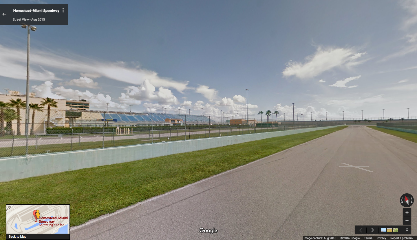
Did you know that starting today you can go on a Street View tour of sports stadiums and arenas? #Winning.
Start by revving your engines, now for the first time, NASCAR fans can zip around the Homestead Miami Speedway. Looping around the track, you can imagine driving at high speed, burning rubber along the way. More interested in tossing around a pigskin? No sweat. Just step out on the field of Century Link Stadium in Seattle, home to the Seattle Seahawks.
If futbol (not football) is what you have in mind, Google Maps can take you out on the big green. Stop by Dick’s Sporting Good’s Park, where the Colorado Rapids play, or the MAPFRE Stadium in Columbus, Ohio, where you can step out on the field like you’re on the Columbus Crew SC. Goallllll!
Shoot some virtual hoops on the court of the Verizon Center in DC, where Washington Wizards, Washington Mystics and Georgetown Hoyas fans all root on their home teams. You can also hit the paint at the AT&T Center in Texas, where the San Antonio Spurs and the San Antonio Rampage take home court advantage.
All these collections and more are also available on your mobile device, so download the Google Map for Mobile app on iOS or Android to preview can't miss spots and get simple directions, no matter which team you're rooting for.
Posted by Deanna Yick, Street View Program Manager
Looking for the perfect place to eat and drink today? Good news: Google Maps has got a menu for you. Starting today in France, Italy, Spain, Germany and Japan, you can choose the "Explore around you" option in Google Maps for mobile on Android to get quick suggestions for places to eat and drink that suit your style. Already available in the U.S. and U.K, whether you’re you’re a tourist looking for a top-rated dinner spot or a local trying to find a new neighborhood watering hole, Google Maps can help you make a delicious, timely discovery while you’re on the go.
Say you're in Milan looking for a quick bite between meetings, or you want a great spot for dinner with kids in Berlin. Tap the “Explore around you” icon at the bottom of Google Maps for mobile for a quick look at what's nearby. Options are organized by category, and once you pick the one that catches your eye (and stomach), you can easily swipe through photos and check out ratings and reviews from Google and previous diners. And for select spots, you may see information on why it’s particularly relevant to you: for example, Google Maps may recommend a place that’s popular with other diners who visited a place you’ve been to in the past.
Finally, if you’re in Tokyo or Paris, you’re in for a treat: an expanded list of categories for your taste buds are available. For Parisians, categories like Lieux mythiques; Brasseries classiques and Un verre avec une vue; En vue de la Tour Eiffel may surprise and delight. While in Tokyo, jazzy spots listed in the オールドスクール ジャズ レトロなジャズバーとクラブmight pique your interest. Pro tip for tourists: Google Translate may also come in handy when exploring these categories!
Whatever flavor you’re searching for, we hope Google Maps gets you there.
Posted by Bryan Cheng, Product Manager, Google Maps
While you may know which team you’re cheering for this Sunday, chances are you’re undecided on another big question: where you’ll watch the football finale. Google Maps just scored you the perfect guide to the big game, so you can focus on getting your game face on.
Starting today on Google Maps for Android in select cities across the U.S., you can discover the spots near you where you can get a great seat for kickoff. Just open Google Maps, tap on “explore food & drinks in this area” and select “Best Spots for the Big Game - Where to eat, drink & watch.” You’ll see a curated list of bars and restaurants around you where you can go to watch the biggest game (and best commercials) of the season. The experience is available in New York, Los Angeles, Chicago, Philadelphia, Dallas-Ft. Worth, San Francisco, Boston, Seattle, Denver and Charlotte.
If you’re attending the festivities in person in the Bay Area, explore a My Map highlighting the locations of all the key events. Public transit is the recommended form of transportation, but if you must drive, use the Google Maps app to get around. We covered all the local road closures and transit schedule changes so you can get where you’re going without missing a play.
For those wanting to explore more of what the Bay Area has to offer, Google Maps Local Guide and foodie expert Kristin Rimbach has used My Maps to put together an insider’s guide for you to experience the best of the East Bay, the South Bay, and the city itself. East Bay highlights include some Latin love at Brazil Cafe and unmissable mac and cheese at Homeroom. If you’re going to stay within SF’s 49 square miles, she recommends stopping by Suppenkuche for hearty German fare and Smitten Ice Cream for a sweet treat.
To access these recommendations on the go, visit Kristin’s My Map and tap the star toward the top left of the map. That’ll save the My Map in Your Places in Google Maps so you can pull it up when you’re ready to explore.
Whether you’re sporting orange or blue this Sunday, we’ll help make your big game a touchdown, not a toss up.
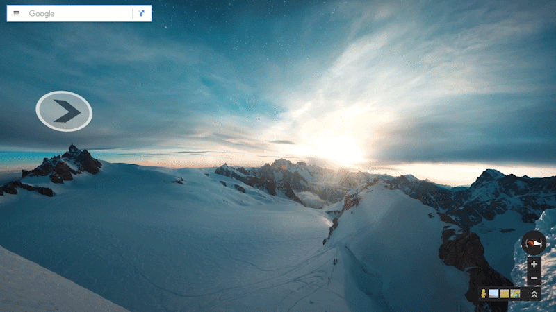
Declared the “monarch of mountains” by Lord Byron, the Mont Blanc massif is shrouded in mystery, rolling clouds and imposing snowfields. One of Europe’s highest peaks, the wild terrain of the famed mountain range is reserved for ardent mountaineers and intrepid explorers. Starting today in Google Maps, you can get an up-close, 360-degree look at the breathtaking beauty of Mont Blanc. Following last year’s first-ever vertical imagery collection of El Capitan in California’s Yosemite National Park, we partnered with world-renowned alpine photographers, skiers, mountaineers, climbers, and runners to collect Street View of Western Europe’s highest peak.
By working with legendary adventurers, the Street View team was able to capture the spirit of the massif in a way few witness firsthand. Run on the summit with Kilian Jornet—he holds the speed record for ascending and descending Mont Blanc in just 4 hours 57 minutes! Ice climb up a serac with record-setting alpine climber Ueli Steck, or go knee deep in powder alongside 14-time ski mountaineering champion Laetitia Roux and famed guide Patrick Gabarrou.
Renan Ozturk, acclaimed cinematographer and National Geographic Adventurer of the Year, alpine photographer Jonathan Griffith, and Sender Films joined Google on Mont Blanc as part of the team.
If reaching the top is what you care about, elite guide Korra Pesce joined the troupe by carrying the Street View Trekker up and down the Goûter Route of Mont Blanc. Click through the Street View to get his first-person perspective of each step to the summit.
Climb the entire Goûter Route of the Mont Blanc massif
Unfortunately, Mont Blanc’s glaciers are receding due to climate change. You can learn more about how the rising temperatures are directly affecting the mountain from legendary guide Patrick Gabarrou, who describes the the glacial melt on the Mer de Glace. So this Street View imagery also serves as a digital record of Mont Blanc as it appears today, so future outdoor enthusiasts and scientists can look back at this time capsule to see how the mountain has changed.
Kilian Jornet on the summit of Mont Blanc
Whether you choose to run up the Mont Blanc with Kilian Jornet or ski down with Laetitia Roux, we hope you enjoy reaching new heights in Europe’s beautiful and endangered mountain range. Posted by Sandy Russell, Project Lead, Mont Blanc Street View