This year, we’ve made it easier to find information that helps you stay safe, up-to-date, and connected. Since the start of the pandemic, we’ve added nearly 250 new features and improvements to Google Maps to help you adapt to this new normal—from live busyness information for millions of places, to the ability to easily see critical health and safety information at a glance. And we’re continuing to invest in ways to keep information in Maps fresh, with over 50 million updates made to the map each day. Even as the holidays approach, we don’t plan on slowing down. If you need to be out and about this holiday season, here are four ways that Google Maps can help you get around safely and get things done.
Get around
Whether you’re heading out of town or staying local, keeping a pulse on the latest COVID trends can help you stay safe. Since we launched the COVID layer, it’s helped nearly 10 million people get critical information about COVID-19 right from Google Maps.
We’re rolling out two new improvements in the coming weeks. The updated COVID layer on Android and iOS will soon show more information, including all-time detected cases in an area, along with quick links to COVID resources from local authorities. This is especially handy if you’re heading out of town and need to get up to speed about the local guidelines, testing sites and restrictions in another city.
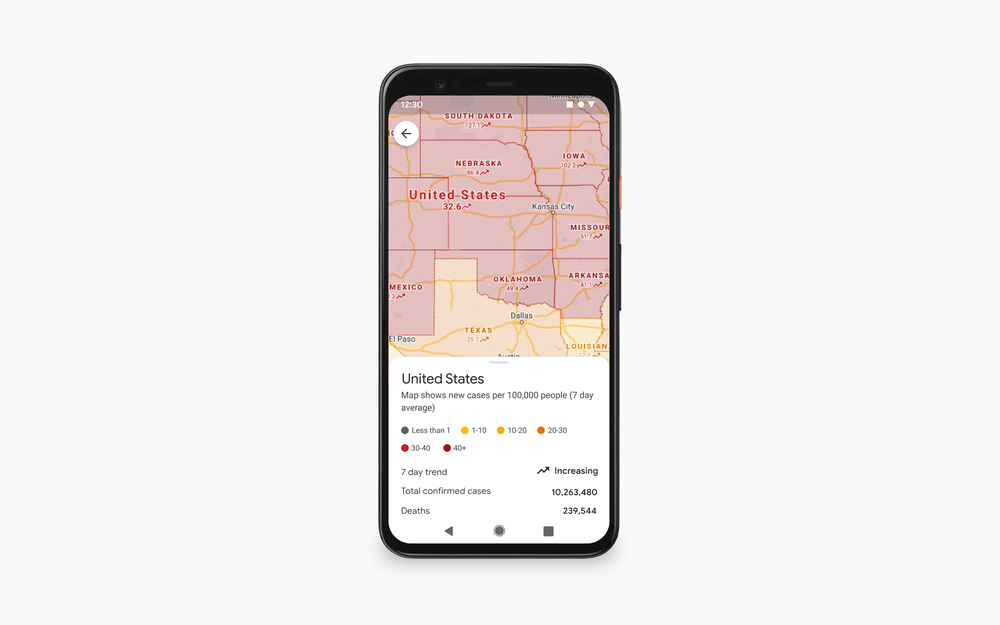
Now you can see all-time detected COVID-19 cases in an area and links to local, authoritative resources right from the COVID layer
Avoiding holiday crowds might have always been your thing, but this year, we’re making it especially easy for everyone. If you need to take transit, Google Maps can help you more easily social distance with live crowdedness information. On Android and iOS globally, you’ll start seeing how crowded your bus, train, or subway line is right now based on real-time feedback from Google Maps users around the world (wherever data is available).
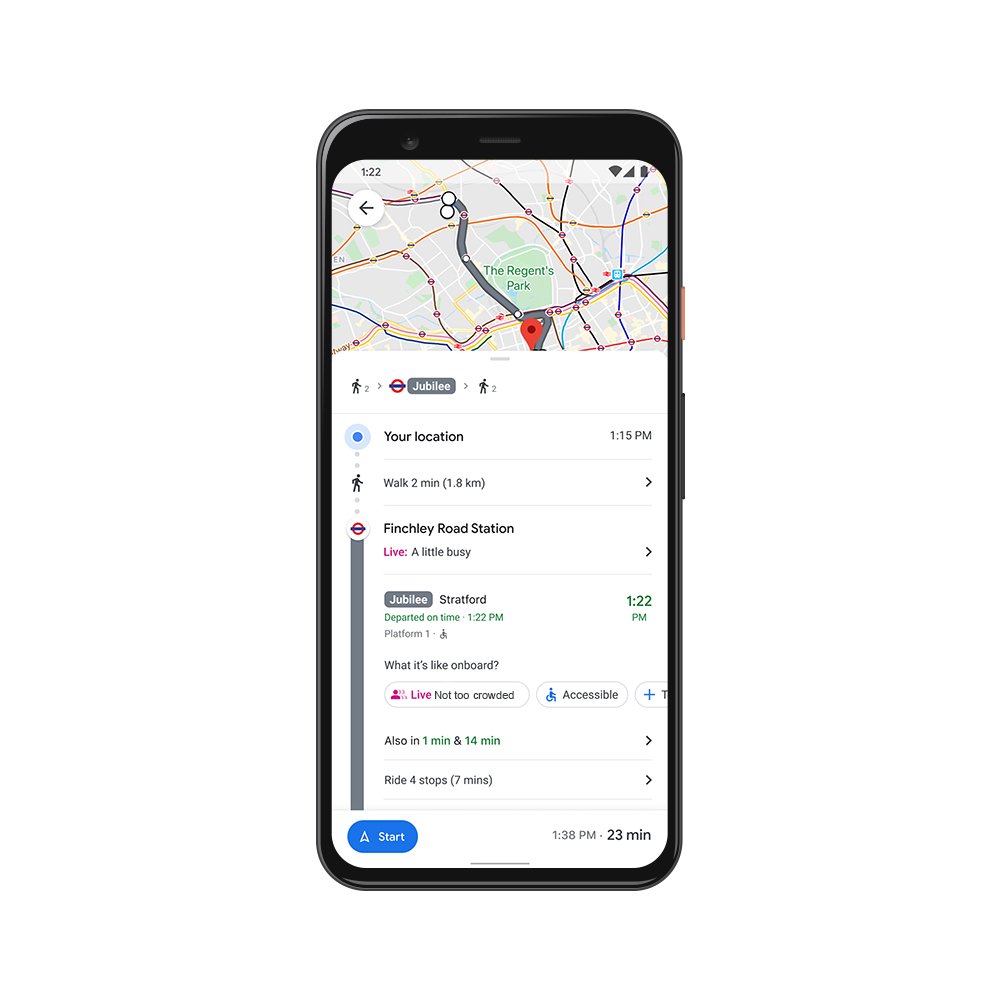
See how crowded your transit line is right now
The right information, at just the right time
You may be in the mood to cook an elaborate holiday meal—or you may not. If you fall into the latter category, we’re rolling out the ability to see the live status of takeout and delivery orders in the United States, Canada, Germany, Australia, Brazil and India when you book or order from Google Maps on Android and iOS. Now, you can know when to pick up your food, or when you can expect it to arrive at your doorstep. You can also see expected wait times and delivery fees, and easily reorder your favorites right from the Google Maps app. And when it’s safe to head to restaurants, you’ll soon be able to quickly see the status of your reservation in 70 countries around the world.
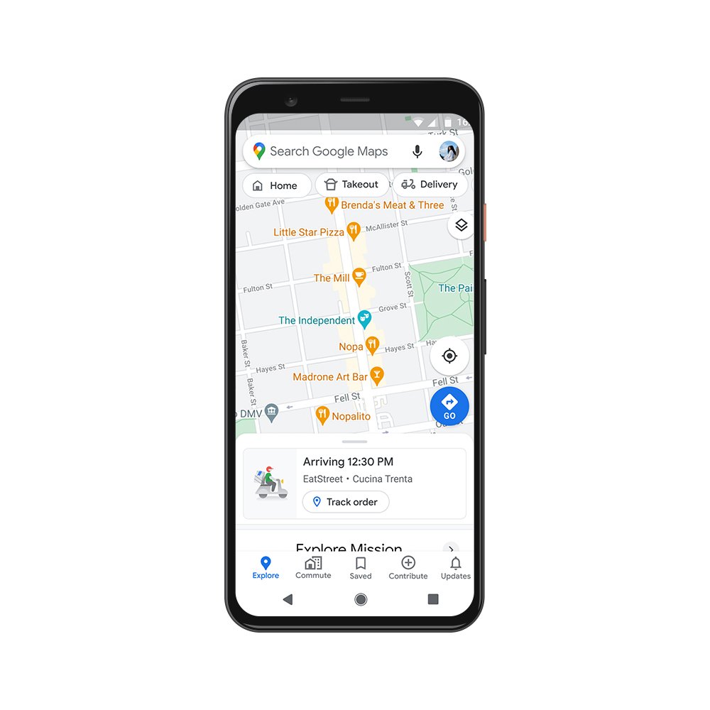
Now you can see the live status of your takeout or delivery order
Get more done
Even without a global pandemic, the holidays are busy and you may need to spend some time on the road. Last year, we shared an early look at Google Assistant driving mode in Maps, and today, we're starting to roll out an early preview of the improved experience to Android users in English in the U.S.—with more features coming soon.
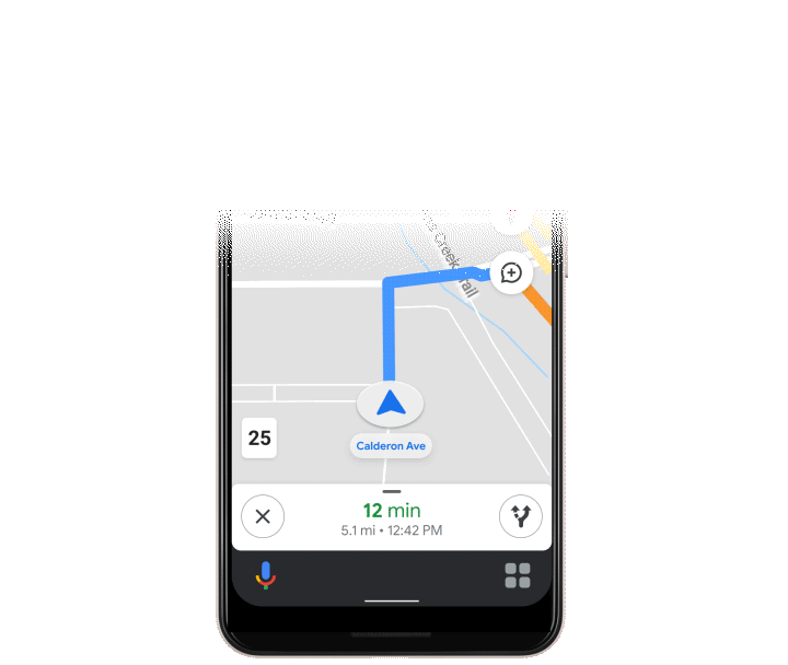
Assistant driving mode in Maps lets you get more done while keeping your focus on the road
While the ways we make life easier for you have changed, our commitment to do this has been there all along. Over the past 15 years, Google Maps has used technology to bring helpful information about the real world right to your fingertips. To make sure that information is as accurate and up-to-date as possible, we rely on 170 billion high-definition Street View images from 87 countries, contributions from hundreds of millions of businesses and people using Google Maps, and authoritative data from more than 10,000 local governments, transit agencies and organizations. We also invest in technical approaches that power some of our most beloved and essential features—from the 20 million places globally that now show popular times data to AR-powered Live View.
Even in a pandemic, more than 1 billion people still turn to Google Maps to navigate their new normal—and our work is far from done. We’re continually working to build new features and services to help all of us emerge from this challenging time stronger than ever. So whatever your plans are this holiday season and no matter how much they’ve changed, Google Maps can make them easier and safer for you.

