Tag Archives: maps and earth

How technology can help us become more sustainable

We want to create technology that helps millions of others understand our changing world and live more sustainably—whether it’s connecting people with public transit routes, or using the data that powers Google Earth to help you see if your roof is good for solar panels. In honor of Earth Day this month, we’ve gathered together some of the ways Google can help you reduce your everyday emissions and learn more about preserving our world.

Monitoring forests and wildlife
Google Earth satellite technology gives scientists and environmentalists a way to measure and visualize changes of the world on both land and water. This technology can have great impact on monitoring endangered animal populations around the world. For example, with the help of Global Forest Watch, powered by Google Earth Engine, scientists at the University of Minnesota are suggesting that wild tiger populations may rebound by 2022, due to the efforts to restore tiger habitats in key regions.
Anyone can now view tiger conservation areas (in orange and yellow above) using Global Forest Watch.
Going solar
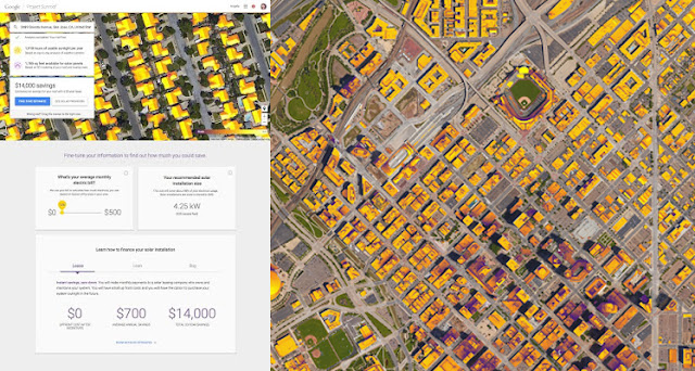
Looking to generate clean energy savings with solar power on your home? Check out Project Sunroof, a solar calculator that estimates the impact and potential savings of installing solar on the roof of your home. Taking Google Earth imagery and overlaying annual sun exposure and weather patterns, Sunroof is able to assess viable roof space for solar panel installation, estimate the value of solar and savings based on local energy costs, and connect you with providers of solar panels in your area.

As of this week, Sunroof expanded to 42 states across the U.S. (from 10 states in December), which makes imagery and data available for a solar analysis to 43 million rooftops. We’re also working with organizations like Sierra Club and their Ready for 100 campaign to help analyze the solar potential of cities across the U.S.
Project Sunroof shows you the solar potential of your home and city, allowing you to realize its renewable potential. The image on the right shows how much sunshine Denver, CO residents can capture with solar.
Measuring air pollutants
For the past few years, Google Earth Outreach and the Environmental Defense Fund (EDF) have been working together to map methane leaks from natural gas pipelines under our streets. Since methane is a very potent greenhouse gas (GHG), even small leaks can add up to big emissions that can hurt our climate. By attaching methane analyzers to select Street View cars, we’ve driven more than 7,500 miles and have mapped 4,200+ leaks in 10 cities. What we found ranges from an average of one leak per mile (in Boston) to one leak every 200 miles (in Indianapolis), demonstrating the effectiveness of techniques like using plastic piping instead of steel for pipeline construction. We hope utilities can use this data to prioritize the replacement of gas mains and service lines (like New Jersey’s PSE&G announced last fall). We’re also partnering with Aclima to measure many more pollutants with Street View cars in California communities through this year.

Anyone can explore the maps at www.edf.org/methanemaps.

Technology is crucial to increasing energy efficiency, raising climate change awareness, and sustainability efforts. To learn more about what you can do to help, take a moment to explore our Google Earth Outreach site, where these tools and more are described in depth.


Reach new heights with Street View of Mont Blanc in Google Maps

Declared the “monarch of mountains” by Lord Byron, the Mont Blanc massif is shrouded in mystery, rolling clouds and imposing snowfields. One of Europe’s highest peaks, the wild terrain of the famed mountain range is reserved for ardent mountaineers and intrepid explorers. Starting today in Google Maps, you can get an up-close, 360-degree look at the breathtaking beauty of Mont Blanc. Following last year’s first-ever vertical imagery collection of El Capitan in California’s Yosemite National Park, we partnered with world-renowned alpine photographers, skiers, mountaineers, climbers, and runners to collect Street View of Western Europe’s highest peak.


By working with legendary adventurers, the Street View team was able to capture the spirit of the massif in a way few witness firsthand. Run on the summit with Kilian Jornet—he holds the speed record for ascending and descending Mont Blanc in just 4 hours 57 minutes! Ice climb up a serac with record-setting alpine climber Ueli Steck, or go knee deep in powder alongside 14-time ski mountaineering champion Laetitia Roux and famed guide Patrick Gabarrou.

Ueli Steck ice climbing on Mont Blanc

You can also join French climbing legend Catherine Destivelle on the imposing yet beautiful Aiguille du Midi, the 3842-meter peak near the Mont Blanc. Or, crouch below innovative filmmaker and free skier Candide Thovex as he soars through the air or has fun as only he can—by taking his skis from the snow to the grass.


Renan Ozturk, acclaimed cinematographer and National Geographic Adventurer of the Year, alpine photographer Jonathan Griffith, and Sender Films joined Google on Mont Blanc as part of the team.

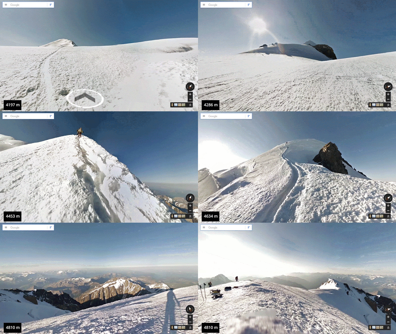
If reaching the top is what you care about, elite guide Korra Pesce joined the troupe by carrying the Street View Trekker up and down the Goûter Route of Mont Blanc. Click through the Street View to get his first-person perspective of each step to the summit.

Climb the entire Goûter Route of the Mont Blanc massif

Unfortunately, Mont Blanc’s glaciers are receding due to climate change. You can learn more about how the rising temperatures are directly affecting the mountain from legendary guide Patrick Gabarrou, who describes the the glacial melt on the Mer de Glace. So this Street View imagery also serves as a digital record of Mont Blanc as it appears today, so future outdoor enthusiasts and scientists can look back at this time capsule to see how the mountain has changed.

Kilian Jornet on the summit of Mont Blanc

Whether you choose to run up the Mont Blanc with Kilian Jornet or ski down with Laetitia Roux, we hope you enjoy reaching new heights in Europe’s beautiful and endangered mountain range.


http://3.bp.blogspot.com/-i70rtEuFhaA/VqAgIN7MI2I/AAAAAAAAEtw/PXgYz379QtA/s1600/Ueli%2BIce%2BClimbing_25MB.gif

Walk the ruins of Peru’s most historic site: Machu Picchu

Take a train ride through the Andes, above the sacred valley and atop the mist of the mountains, to the most historic site of the Inca Empire. Machu Picchu, a UNESCO World Heritage Site and one of the New 7 Wonders of the World, is one of the most famous, mythical and spiritual sites in the world. Now for the first time, in partnership with the Peruvian Ministry of Culture, people across the globe can go on a journey to Machu Picchu directly in Google Maps, uncovering its temples, terraces and plazas that have remained intact since the 15th century. People can also explore rare Inca artifacts and expert insights on the Google Cultural Institute.

Gazing at the Historic Sanctuary of Machu Picchu more than 2,400 meters above sea level, the site below is a lasting tribute to the power of the Inca Empire. It’s still unclear how the structure composed of behemoth stones was so precisely built without the use of mortar or modern day machinery, but its walls, terraces and stairways weave effortlessly into the mountainside and natural landscape.
Historic Sanctuary of Machu Picchu, Peru

Standing in the Templo Principal, you can imagine how many people have stood at this central gathering place before you. Located at the highest position of the city, this site holds great spiritual meaning to the people of the Citadel. And touring the vast Plaza Principal allows you to virtually walk one of the most sacred ceremonial grounds on the site, which once hosted social and religious celebrations for the Inca.
Plaza Principal of Machu Picchu

Within the long and narrow compounds, called kanchas, you can also explore the Observatorio Astronómico (Intiwatana), Templo del Sol, and Templo de las Tres Ventanas—sites dedicated to Inti, the Inca Sun god—or marvel at the architectural complexity of structures like the Grupo de las Tres Puertas, whose doors lead to the main square.
Grupo de las Tres Puertas, Machu Picchu, Peru

After virtually touring these sacred and ceremonial spaces, discover more Wonders of Machu Picchu on the Google Cultural Institute. You can explore more than 130 Inca artifacts online thanks to the Museo Macchupicchu at Casa Concha. In three new online exhibits, the museum's curators share their expert insights on the Inca's daily life and rituals—which are still a subject of great mystery and fascination over 500 years later. Highlights include a perfectly preserved pair of plates decorated with butterflies, and an ingenious device of strings and cords used for record keeping and accounting. See these rare objects in the context of the museum by taking a virtual tour.
Inca accounting device

Whether you visit Machu Picchu via a train or hike up the Inca Trail, we’d be honored to be your virtual guide through this sacred space. And while in the area, enjoy exploring still more archaeological treasures from this ancient civilization at the Museo Machupicchu at Casa Concha, which holds the largest collection of Inca artifacts in the world.

Machu Picchu, a true wonder of the world, is now just a click away.

IMAGE URL