Author Archives: Google LatLong

Updates in Maps and Search to help during times of crisis

SOS alerts help you quickly access authoritative, real-time information during times of crisis. Today, we’re improving SOS alerts by adding visual information about natural disasters and a new navigation warning system on Google Maps so you can more reliably know where a disaster is and anticipate where it’s headed. Read on to learn about what’s changing, along with three ways to help you stay connected and informed during times of emergency.

Hurricane forecast cones, earthquake shakemaps and flood forecasts

With SOS alerts, you can already see important crisis information—a summary of what’s happening, relevant news stories, emergency phone numbers and websites, Twitter updates from local authorities, and tips to help you find your way to safety. Now, you’ll also be able to see detailed visualizations about hurricanes, earthquakes, and floods to give you a better understanding of the situation on the ground.

In the days leading up to a hurricane, you’ll see a crisis notification card on Google Maps that automatically appears if you’re near the impacted area. This card will direct you to a hurricane forecast cone, which shows the prediction of the storm’s trajectory along with information about what time it’s likely to hit certain areas, so you can use this information to plan how to react.

After an earthquake strikes, tapping on the crisis card will display the earthquake’s shakemap—a visualization that shows you its epicenter, its magnitude, along with color coding to indicate how intense the shaking was in surrounding areas. This information can help you quickly assess the reach of the earthquake and and identify areas likely to have experienced the highest impact.  And in India, where over 20 percent of global flood-related fatalities occur, you’ll now be able to see flood forecasts that show you where flooding is likely to occur in addition to the expected severity in different areas.


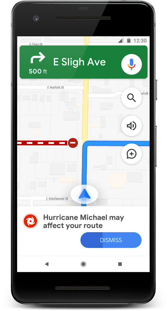
Crisis navigation warnings on Google Maps

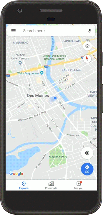
Later this summer, you’ll see a prominent alert if we think your route may be affected by crisis activity— and when possible, we’ll do our best to route you away from the disrupted area.


nav warning

During a crisis, every minute matters. Here are three other ways you can use Google Maps to stay connected and quickly get the help and information you need:

  • Share your location:Letting loved ones know where you are is vital during fast-moving, chaotic situations. From the crisis card, you can share your live location with friends and family for as little as 15 minutes, or until you decide to stop sharing.

  • See and report road closures: Turn on the traffic layer to see all known and suspected road closures in an area. If you encounter a closure on your drive, you can report it to help others nearby. You can also confirm whether or not a road is still closed with a quick tap on Android.

  • Share crisis information directly with the ones you care about:Tap on theshare button from the crisis card to keep friends and family up to date about the situation. They’ll be directed to Google Maps where they’ll see all available crisis information- which could include a summary, visualizations, emergency contact information, and more.

Hurricane forecast cones and earthquake shakemaps will start rolling out in the coming weeks on Android, iOS, desktop, and mobile web. Flood forecasts visualizations will soon roll out starting in Patna, India, and then expand to the Ganges and Brahmaputra regions on Android, desktop, and mobile web.


Source: Google LatLong


Stonewall Forever: Honoring LGBTQ+ history through a living monument

Many people have shaped my life—my parents who brought me into the world; Miss Moran, my fifth grade teacher, who pushed me to be a better student; my late mentor Bill McCarthy who helped guide my career early in my professional life. But perhaps the most meaningful people in my life are my husband, whom I have been with for nearly 30 years, and my son, who gives me more joy (and a fair amount of frustration) than I could have ever imagined. For them, I owe thanks in large part to a valiant handful of New Yorkers whom I've never me. Their act of defiance ultimately enabled me to live, love and be who I am.

It was early in the morning on Saturday, June 28, 1969, when the police raided the Stonewall Inn on Christopher Street, one of the few places at the time where LGBTQ people could gather openly. New Yorkers fought back. This altercation, known as the Stonewall Riots, led to angry protests that lasted for days and sparked the modern fight for LGBTQ rights around the world.

In 2016, President Obama designated Christopher Park, the small triangle of green that sits in front of the Stonewall Inn, as the first national monument dedicated to telling the story of this community’s struggle. The Stonewall National Monument serves as a reminder of the continuing fight for civil and human rights.

This year marks the 50th anniversary of Stonewall. To recognize this pivotal moment in history, the LGBT Community Center of New York City (The Center) spearheaded the creation of Stonewall Forever, an interactive “living monument” to 50 years of Pride. Google provided support in the form of a $1.5 million grant from Google.org, and volunteers from Google Creative Lab helped bring the experience to life.

Stonewall Forever connects diverse voices from the Stonewall era to the millions of voices in today’s LGBTQ community. The monument is made up of countless colorful pieces that contain digitized historical artifacts, oral histories capturing the early days of the movement, interviews with new voices of LGBTQ equality, and photos and messages added by people around the world.

Anyone can visit Stonewall Forever on the web, and through an augmented reality app that allows you to experience the Stonewall National Monument in New York’s Christopher Park. Explore the past, present and future of Pride and then add your own piece to the ever-growing monument. You can dive deeper by watching a short documentary, directed by Ro Haber, featuring an inclusive array of activists, from across generations, each giving their own interpretation of the Stonewall legacy.

Beyond our support of Stonewall Forever, we’re launching Pride Forever, a campaign honoring the past, present, and future of the LGBTQ+ community. This theme is rooted in sharing the past 50 years of global LGBTQ+ history with our users. Today’s interactive Google Doodle celebrates 50 years of Pride by taking us through its evolution over the decades, with animated illustrations by Doodler Nate Swinehart.  

Google Arts & Culture is also preserving even more archives and stories from LGBTQ history, in partnership with The Center,GLBT Historical Society of San Francisco, the National Park Service’s Stonewall Monument, and Cyark. The collection includes never-before-seen photos and videos, 3D models of the Stonewall monuments, and a virtual walking tour of LGBTQ sites in the Village.

Here are a few other ways we’re helping people celebrate Pride.

  • Like past years, we’ll identify major Pride parade routes on Google Maps.
  • Later this month, check out Google Play for apps, movies, books, and audiobooks to help the LGBTQ+ community share stories and also learn more about the history of LGBTQ+ rights.
  • And through Google My Business, business owners can mark their businesses as “LGBTQ-friendly” and as a “Transgender Safe Space” on their Google listing to let customers know they’re always welcome. As of today, more than 190,000 businesses have enabled these attributes on their business listing.

Today, Stonewall lives on in images, histories and monuments—old and new. It also lives on in the LGBTQ community and its supporters. The past paves the way for the future, and Stonewall Forever reminds us that alone we’re strong, but together we’re unstoppable. Pride is forever.

Source: Google LatLong


Pick up the pace with three fitness apps, powered by Google Maps

When I began training for my first marathon 12 years ago, planning my routes was a big challenge. I’d often write directions on my wrist or carry a crumpled up paper map in my pocket. I’ve run many more marathons since then, and just last month, ran the Boston Marathon for the first time. But my training for Boston was vastly different because of my work at Google. I’m on a team that helps businesses—like those who build location-enabled fitness apps—to integrate data and insights from Google Maps into their products. So this time around I relied on a few of those apps to train, instead of my usual primitive methods (pro tip: paper maps don’t handle sweat very well).

Today’s the last day of National Physical Fitness and Sports Month, so I’m highlighting a few companies that are using Google Maps to keep their users (like me!) in the zone. Here are a few of my personal favorites and how they use Google Maps Platform.

Garmin

Overview of my route and stats from my Garmin Forerunner


Feeling a little safer while training

New runners don’t have to train without a location-enabled device (known in the running community as running “naked”). But if you’re like me and have been running for over a decade, you may remember the thrill of having only a vague sense of your pace and distance––and of course, getting hopelessly lost.

Now I rely on my smartphone and Garmin Forerunner to help keep me on pace and on track, and suggest new trails and routes. Garmin uses our highly accurate location technology to provide metrics such as speed, distance, and elevation, as well as safety features. When running on remote trails, I can quickly and discreetly activate the assistance feature if I ever feel unsafe and share my location with pre-selected emergency contacts.

NordicTrack

Doing a Street View run in Lago di Vernago, Italy


Training with real-world imagery and conditions

When I’m not running outdoors, I’m logging miles on my NordicTrack treadmillbefore my kids wake up. Although treadmillers seem impervious to that particular flavor of boredom, running indoors doesn’t mean staring at a blank wall anymore.

NordicTrack, a treadmill made by ICON Health & Fitness, the world’s largest fitness equipment manufacturer, lets you trace a route anywhere in the world and run that route using Google Street View. So when temperatures hit triple digits or dip anywhere below 50 degrees (which is Texan for “freezing”), I can do a loop around my favorite neighborhood in Paris, or run up to one of Mount Everest’s base camps without leaving the house.

I can also run several marathon courses right on the treadmill. Using information from Google Maps Platform, NordicTrack automatically accounts for real-world conditions. When training for the Boston Marathon this year, I was able to simulate the infamous Heartbreak Hill (worth preparing for both physically and mentally!). And when doing a coached workout, the speed automatically increases during intervals, allowing me to focus on my workout without having to make manual adjustments.

ZombiesRun

My stats after a Zombies, Run! adventure

Finding new ways to push my limits

Sometimes you have to find new ways to motivate yourself to run farther or to get out and train when you’re not feeling up to it. As someone who suffers from kinemortophobia (that’s a fear of zombies, to save you the Google search), I was reluctant to try Zombies, Run!. But I’m so glad I did. It combines storytelling, role playing, gamification, and fitness to help people push their limits. The game weaves our location data and distance info into a riveting and surprisingly hilarious storyline where you avoid zombies and collect supplies along your journey. Zombies, Run! helps push me a little harder whenever I hear those zombies getting closer and helps me run just a little further when I’m close to the end of a mission.

While zombies chase me as I train for the Tunnel Marathon in September, I’m hoping to break my personal record and qualify for the next Boston Marathon. Whether it’s discovering new running routes around the world on my treadmill or exploring new trails with my Garmin (still managing to get lost sometimes!), I’m proud to be a part of the team that brings Google Maps to fitness companies to keep us connected and moving.

Source: Google LatLong


Take a walk through Kakadu on Google Street View

In Australia’s Top End, you will find the country’s largest national park: Kakadu National Park. Covering almost 20,000 square kilometers (about half the size of Switzerland) and with terrain encompassing wetlands, rivers and sandstone escarpments, it’s home to the world’s oldest living culture with more than a dozen Indigenous groups. One-third of Australia’s bird species, an estimated 10,000 crocodiles and approximately 2,000 plant species can also be found in the Park.


Today, on its 40th anniversary, we're inviting people across the world to visit Kakadu National Park on Google Street View—to walk through ancient “stone country”, stare at spectacular waterfalls and discover ancient rock art.
Street View Trekker at Nawurlandja

Google Street View Trekker taking in the panoramas at Nawurlandja. 

Considered a living cultural landscape, Kakadu National Park’s geological history spans more than two billion years. The Park is a place that boasts extraordinary archaeological sites that record the skills and ways of life of the region’s Aboriginal people, whose culture stretches back more than 65,000 years. The Street View journey captures a glimpse of this world, uncovering rock art galleries and stunning vistas across eight sites.

Anja Toms from Kakadu National Park

Anja Toms from Kakadu National Park explains the significance of rock art at Burrungkuy (Nourlangie).

Viewers can journey to Ubirr for incredible 360-degree views, or to take a look at rock art galleries that record animal life in the region going back thousands of years. This includes a painting of a thylacine—or Tasmanian Tiger—depicted before they became extinct on the mainland around 2,000 years ago.

Kakadu National Park Rangers

Sean Nadji and Fred Hunter, Kakadu National Park Rangers, look out over Ubirr.

You can also meander through towering sandstone pillars at Bardedjilidji, travel to Nawurlandja for world-class panoramas across Anbangbang Billabong and the Arnhem Land escarpment, and toward Burrungkuy (Nourlangie) where you can view rock art galleries, before cooling off in the pristine plunge pools at Maguk or Gunlom (one of the most popular sites for travellers looking to take a refreshing dip), then diving into Kakadu’s big waterfalls: Twin Falls and Jim Jim Falls.

This journey through Kakadu National Park is a continuation of our work with Traditional Owners, Tourism Northern Territory and Parks Australia to record and share sacred sites, and instill greater value and respect for the land—which began in 2017 with Uluṟu-Kata Tjuṯa National Park.

Visit Kakadu National Park, dual-listed by UNESCO World Heritage for both its natural and cultural significance, on Google Street View to learn more about the world’s oldest living culture and their connection with the land.


Source: Google LatLong


Four tools to help drive your nonprofit’s mission forward

Google for Nonprofits started as a conversation about a volunteer program in an elevator in our New York office in 2010. Today, Google for Nonprofits has connected more than 200,000 nonprofits around the globe with Google products to help them run their organizations.

We believe that technology can do good in the world, which is why we offer eligible organizations access to a suite of Google products at no cost. Here’s a look at what each of the Google for Nonprofits products has to offer:

Bring teams together with G Suite for Nonprofits

G Suite is a set of integrated apps, including Gmail, Docs, Calendar, Drive and Hangouts Meet. It helps organizations with productivity, collaboration, and security—with G Suite, teammates can work from anywhere, on any device and focus their time on making an impact. If your nonprofit works across different locations, you can use G Suite to organize online video conferences on Hangouts, create group chats, work together simultaneously on the same document and much more.

Team Rubicon UK is a disaster response organization that needs to be prepared for and quickly respond to crises around the world. Using Google Forms and Sheets, Team Rubicon can go from 1,000 potential volunteers to a group of 12 skilled volunteers on the ground supporting a crisis within 24 hours.

Reach more supporters with Google Ad Grants

Google Ad Grants connects people to causes with $10,000 per month in free Google Advertising. Nonprofits can create ads to raise awareness, attract donors and help people around the world.

American Humane, the first national humane group in the U.S., uses Ad Grants to increase the organization's exposure and educate people on their work in the animal welfare space. In one year, Google Ads drove over 1,000 new people to donate or sign up to volunteer and over 600 people to complete a service dog application.

Show your nonprofit’s impact with Google Maps & Earth

Google’s mapping tools help nonprofits in a wide range of ways, from tracking and sharing an organization’s impact to taking supporters on a virtual tour. To help organizations get started, Google for Nonprofits provides Google Maps Platform credits to nonprofits.  

iNaturalist, part of the California Academy of Sciences in San Francisco, uses Google Maps Platform to encourage environmental stewardship. It uses crowdsourcing, maps and photo sharing to gather data that helps conversationalist save a species before it becomes extinct. iNaturalist has succeeded in its goal of getting hundreds of thousands of people to connect with the natural world and continues to help scientists discover crucial findings about species.

Engage your supporters using video with the YouTube Nonprofits Program

YouTube amplifies your nonprofit’s reach by telling your story to a global audience.  Through the YouTube Nonprofit program, you’ll get access to Link Anywhere Cards that direct your viewers to your external campaign landing pages and to Creator Academy lessons tailored to nonprofits. Your nonprofit can also get access to the YouTube Space in Los Angeles or New York to shoot or edit your videos at YouTube’s creator studio. Just visit Space LA or Space NY and click the “Apply Now” button.

KMVT 15 is an award-winning nonprofit television station and media center that provides a community forum, media literacy education, hands-on training and civic engagement to local residents. KMVT 15 used YouTube for Nonprofits to engage its audience at a global scale: their YouTube channel has garnered more than 4.5 million views and seven thousand subscribers with a minimal marketing budget.

We’re inspired every day by the nonprofits across more than 50 countries who use our products to advocate their causes and make a real difference. If you’re interested in how Google’s technology can help your nonprofit, click here tolearn more.

Source: Google LatLong


Down under, over and all around: Sydney in 3D on Google Earth

Google Earth is one of the world's most comprehensive 3D maps available. In addition to global satellite and terrain coverage, over the past several years we've been adding highly detailed 3D imagery of entire cities and towns, from the iconic architecture of cities like New York and Paris to views of landmarks like the Grand Canyon. And now, we’re sharing 3D imagery of central Sydney, Australia!

But 3D imagery of Sydney isn’t the only thing that’s new today. We've made many incremental improvements to our modeling process that, overall, help us achieve an even more precise 3D landscape. (You can check out this video to learn more about the process.) For a while now, parts of Sydney—sites like Sydney Harbour Bridge and Bondi Beach—have already been available in 3D. Expect to see this quality across all of our new Earth imagery.

Central Sydney sits beneath busy airspace, so it’s taken a while to make 3D models of the area. We’ve finally collected enough imagery to build a more complete picture of this iconic city. Explore landmarks like the Sydney Opera House and popular tourist spots Darling Harbour and The Rocks. You can even plan your next visit to Sydney with our guided tour, Explore Sydney.

You can see all the places where we have 3D imagery available in Google Earth.

Source: Google LatLong


To help fight the opioid crisis, a new tool from Maps and Search

In 2017, the Department of Health and Human Services (HHS) declared the opioid crisis a public health emergency, with over 130 Americans dying every day from opioid-related drug overdoses.  Last month, we saw that search queries for “medication disposal near me” reached an all-time high on Google.

opioids_data

53 percent of prescription drug abuse starts with drugs obtained from family or friends, so we’re working alongside government agencies and nonprofit organizations to help people safely remove excess or unused opioids from their medicine cabinets. Last year, we partnered with the U.S. Drug Enforcement Administration (DEA) for National Prescription Take Back Day by developing a Google Maps API  locator tool to help people dispose of their prescription drugs at temporary locations twice a year. With the help of this tool, the DEA and its local partners collected a record 1.85 million pounds of unused prescription drugs in 2018.

Today, we’re making it easier for Americans to quickly find disposal locations on Google Maps and Search all year round. A search for queries like “drug drop off near me” or “medication disposal near me” will display permanent disposal locations at your local pharmacy, hospital or government building so you can quickly and safely discard your unneeded medication.


opioid_gif

This pilot has been made possible thanks to the hard work of many federal agencies, states and pharmacies. Companies like Walgreens and CVS Health, along with state governments in Alabama, Arizona, Colorado, Iowa, Massachusetts, Michigan and Pennsylvania have been instrumental in this project, contributing data with extensive lists of public and private disposal locations. The DEA is already working with us to provide additional location data to expand the pilot.

For this pilot, we also looked to public health authorities—like HHS—for ideas on how technology can help communities respond to the opioid crisis. In fact, combining disposal location data from different sources was inspired by a winning entry at the HHS’s Opioid Code-A-Thon held a year ago.

We’ll be working to expand coverage and add more locations in the coming months. To learn more about how your state or business can bring more disposal locations to Google Maps and Search, contact [email protected] today.


Source: Google LatLong


Now on iOS: Follow your favorite places on Google Maps

Starting this week, you can stay up to date on your favorite places right from the Google Maps app on iOS. Simply search for a place—whether it’s a new restaurant that just opened up in your neighborhood or that must-try bakery across town—and tap the Follow button. You’ll then be able to see important updates from these places in your For you tab so you can quickly learn about upcoming events, offers and more.  

igmm_follow

And now, places and businesses all over the world can see their followers in the Google My Business app, and actively post helpful information for their followers to see. The Follow button starts rolling out on iOS today.

Source: Google LatLong


For the holidays and beyond, your travel planning guide is here

With the holidays approaching, many of us will travel to see family or go on a vacation. Whether you’re heading out of town over the next few weeks or starting to think about a trip in the new year, we’ve rounded up some of our favorite tools to help make travel just a little bit easier.

Check to make sure your flight is on time

Earlier this year, we started sharing flight delay predictions when you search for your flight status and we’re 85% confident that the flight will eventually be delayed. We use historic flight status data combined with machine learning to make these predictions in advance of airlines confirming delays.

To help with the increase in delayed flights this time of year, the Google Assistant now shows you predicted flight delays, too. You can ask things like, “Hey Google, is my flight on time?” or “Hey Google, what’s the status of the American Airlines flight from Philadelphia to Denver?”

And to make it easier to stay up-to-date on changes to your flight time, over the next few weeks the Assistant will begin proactively notifying you on your phone if we predict a flight delay and tell you the reason if we know it.

Assistant Flight Status

Get the lay of the land with Maps

Traveling to a new destination over the holidays? Google Maps can help when you’re navigating and discovering new places where you live, but it’s also essential when traveling somewhere unfamiliar. We’ve recently added information that is especially useful for travelers exploring a new city. Swipe up on the Explore tab at the bottom of your screen to get ideas of what to do.

Google Maps Travel

Plan your post-holiday vacation

Whether you’re coming off a holiday high or in need of relaxation after all the hustle and bustle, the beginning of the new year is a prime time to think about your next trip. Earlier this year, we unveiled a tool that shows you historic flight price trends, top cities with hotel deals and popular things to do. Now you’ll also see upcoming holiday and school breaks, so you can plan trips around those dates.

If you’re looking for a destination with a good mix of activities for you and the group you’re traveling with, start by searching for “things to do” on Google. In addition to top attractions and relevant articles, you’ll now also see popular experiences for the top destinations worldwide. For example, if you search for “things to do in Nashville” you’ll see things like sporting events, wine tours and hiking in your results. We’ve also recently redesigned things to do to make it easier to filter for your interests, including a new kid-friendly option on phones. You can also now see things to do on a map.


Things to do in Nashville

When you’re ready to start looking at flight prices, Google Flights helps you understand what’s included in your ticket price. You’ll see if prices include a carry-on bag and can filter to see the prices that include carry-on luggage. Now you can also filter to include checked bag fees for domestic flights in the U.S.

Bags filter

Wherever you’re headed during this festive time of year, enjoy your time off and travel safely.

Source: Google LatLong