Tag Archives: Street View

Street View arrives in Luxembourg

Luxembourg is the heart of Europe and boasts an above average number of beautiful sites, from the medieval Grund neighborhood in the capital to the ridges of the Moselle River and the sparkling modern Kirchberg center for European Union buildings. And now, thanks to Street View in Google Maps anyone, anywhere can visit these sites from their desktop computer or mobile device.


Viewers can access images taken at street level in two ways, either by dragging the "Pegman" character, located at the bottom right of the map, onto a place highlighted in blue, or by clicking a spot on the map and selecting Street View in the top left of the display window that pops up.

Street View offers myriad benefits. Check what looks like a restaurant before going there; find a place to park the car before you leave the house to go shopping; arrange a meeting point in an unfamiliar location; or help your kids bring their geography studies to life! If you are interested in buying a home, you can explore the area with a few clicks of a mouse; people in wheelchairs can figure out whether places have sufficient access before making a trip.

Street View is all about making Google Maps more useful, comprehensive and interesting for people, and we’re delighted people can now discover all that Luxembourg has to offer.

Denmark’s "Borgen" goes live on Street View

After scaling Swiss mountains and roaring along the new Sochi Formula One race track in recent weeks, StreetView has broken new ground in Europe by launching collection of one of the world’s most interesting political monuments - going inside the Danish parliament Borgen. Our cameras combed the Copenhagen icon’s halls and brought its extensive art collection to the world on our Art Project.


Since the 15th century, the address in the center of Copenhagen has been home to various castles and palaces which ruled the Danish Kingdom, regardless of whether the power was executed by hereditary kings or elected politicians.

Its most famous occupant, arguably, is the cool modern Prime Minister Birgitte Nyborg. She is not a real politician, but the fictional Prime Minister played by actress Sidse Babett Knudsen in the popular Danish political TV series "Borgen." All of us now get the possibility to enjoy the same view as the politicians speaking at the podium. Look closely and you might even find the secret stock of the licorice hidden behind the parliament chairman’s desk.

This project required 18 months of hard work. Credit first goes to Liberal MP Michael Aastrup Jensen, who suggested to the Parliament that the Parliament itself should open up to the world. Negotiations followed with the local copyright association to secure rights to film the Parliament art collections. Some 89 pieces are showcased in the Art Project exhibition. Talks also were needed with the security services to win their approval.

In the end, everyone saw the benefits of putting Borgen online. Please enjoy and explore.

Street View reaches new heights

Street View cars, Trekkers and trikes are always striving to unveil new informative and entertaining views of the world, making Google Maps more useful and comprehensive. In recent weeks, we have launched two exciting European projects — one in Switzerland, the other in Russia — which literally take the images to a new velocity and a new height!
StreetView Trekker climbs the Swiss Alps
Together with the Swiss Alpine Club (SAC) and the Swiss Tourism Board (MySwitzerland.com), we launched a contest called “Queen of the Alps.” High in the Swiss Alps, far from any road or other buildings, are picturesque huts used to spend a night by farmers and vacationers.

It often takes a full day hike to reach these out of the way huts. We ran online vote to find the favorite Swiss hut, promising to film the choice for Street View. The Swiss Alpine Club’s Lauteraarhütte-SAC in the canton of Berne (region “Grimselgebiet”) won. It took our Trekkers a five hour hike up the Grimsels Hospiz to capture this exciting imagery.

The interior of the winning alpine hut
In Russia, the site of our Street View shoot was much more accessible but just as exciting - the Winter Olympic venues in Sochi. Stroll around the Fischt stadium which hosted the opening and closing ceremonies. Walk on the Ice Palace "Iceberg" and visit the Olympic Village, where your favorite team stayed.

In particular, take a look at the new Formula 1 track in Sochi. It is located in the city’s Olympic Park and is the only Formula 1 track in Russia. From October 10-12, Russia will host its first World Championship race.

The new Sochi Formula 1 Track on StreetView
Before the event, we thought it would be cool for racing fans to test out the new track. The new Street View imagery allows anyone, anywhere to preview the route. Take a spin.

Street View arrives in 56th country – Greece

Greece is home to many of the world’s great cultural and historical monuments and remarkable landscapes, making it a natural for Street View, which allows web users to take panoramic real-life virtual tours of public roads. That’s why we’re particularly excited to announce the launch of the pathbreaking service this month, making Greece the 56th country added to Street View. From now on unique Greek landmarks, such as the Corfu Old Town, the White Tower in Thessaloniki and the Arch of Hadrian in the center of Athens, will be vividly represented on our computer screens. We’ve gathered some of our favourite scenes in our Views Gallery.

The serene port in Mykonos
Many Greeks long have been keen for us to bring its benefits to their country, seeing Street View as a powerful tool for the promotion of a country. At a launch event in Athens, Andreas Andreadis, President of the Association of Greek Tourism Enterprises, said the new service will prove invaluable to tourists coming to Greece — and Greek businesses serving them. Visitors now will be able to check their hotel in advance and preview the areas and sites they are about to visit. Street View benefits everyone from the wheelchair user who can check whether a building has a ramp to the elderly who may check whether there are sufficient parking spots before leaving home. Minister of Culture and Sports Panos Panagiotopoulos welcomed Street View in Greece as nothing less than “a gift from God.”


Many other types of Greece businesses will benefit. Anyone can embed Google Maps directly into their site for free, helping them to promote a chain of hotels, tourist places, points of history and cultural importance or increase awareness of a local library or restaurant. Event organizers will be able to evaluate locations, restaurants, hotels, museums. Real estate agents will save time not only by exploring properties.

The White Tower in Thessaloniki, on a typically sunny Greek day
As always, we’ve build privacy safeguards into Street View — we blur people’s faces and vehicle license plates automatically — and if anyone sees a need for additional blurring, they can let us know by clicking on ‘Report a problem’ in the bottom left corner of the screen.

We're excited to be launching our first Greek imagery, but our journey is far from finished - we are already planning to redrive and refresh the Greek imagery.

Get a front seat to the World Cup

The world's biggest soccer tournament is here. Whether you’re watching from the comfort of your couch or packing your bags for Brazil, Google Maps is your ticket to the games. To kick off the tournament, starting today you can explore all 12 stadiums and the iconic painted streets, one of Brazil’s tournament traditions, in Street View which serves as a digital legacy of the 2014 games for years to come.

Exploring the sights and culture of this year’s football tournament has never been easier with Street View in Google Maps.

Rua Professor Eurico Rabelo - Maracanã, RJ

Rua Padre Agostinho Poncet, São Paulo, Brazil
In addition to the stadiums and painted streets, images from hundreds of sites across Brazil, including Iguaçu National Park and St. Michael of the Missions, are also now available on Google Maps.

And if you’re lucky enough to have a physical ticket to Brazil, don’t forget to pack Google Maps for mobile.
  • Transit: With Google Maps transit available in all 12 host cities, Brazilians and visitors alike can rest assured they can make it to the stadium and other destinations routing the best path by bus or train.
  • Indoor Maps: Make your way through more than 100 venues across Brazil, including airports, shopping malls and, yes, tournament stadiums with Indoor Maps.
  • Turn-by-turn navigation: Zip through Brazil from Point A to Point B with Google Maps for mobile, giving you the most accurate traffic info, including real-time incident reports from Waze, and voice-guided directions.
Even if we can't help your favorite team find their way to victory, Google Maps is ready for the assist. You might be (or get) lost without it!

Post content

Google Europe Blog 2014-04-25 12:39:00

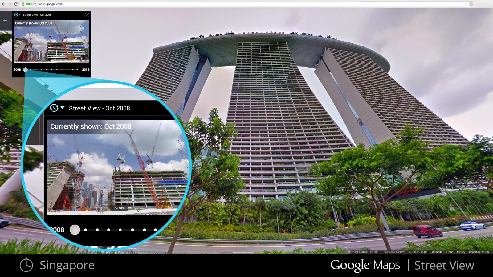
If you’ve ever dreamt of being a time traveler like the movie character Doc Brown, now’s your chance.  Want to experience different seasons and see what it would be like to cruise Italian roadways in both summer and winter?  Starting this week, you can travel to the past to see how a place has changed over the years by exploring Street View imagery in Google Maps for desktop. We've gathered historical imagery from past Street View collections dating back to 2007 to create this digital time capsule of the world.

If you see a clock icon in the upper left-hand portion of a Street View image, click on it and move the slider through time and select a thumbnail to see that same place in previous years or seasons.

Now with Street View, you can see a landmark's growth from the ground up, like the Freedom Tower in New York City or the 2014 World Cup Stadium in Fortaleza, Brazil. This new feature can also serve as a digital timeline of recent history, like the reconstruction after the devastating 2011 earthquake and tsunami in Onagawa, Japan.

Construction of the Freedom Tower, New York City

Destruction in Onagawa, Japan after the 2011 earthquake

Forget going 88 mph in a DeLorean—you can stay where you are and use Google Maps to virtually explore the world as it is—and as it was. Happy (time) traveling!


Bringing the Opéra to the Cultural Institute

For the first time, the Google Cultural Institute has been given ‘access all areas’ to one of the world’s most famous Opera Houses: the Palais Garnier in Paris, the setting for The Phantom of the Opera.

Our indoor Street View images feature exquisite detail and allow anyone in the world to tour 11 floors (and 3.7km!) of the Palais Garnier. You can now experience virtually what it’s like to be on stage, backstage, in the rehearsal rooms, the costume room, a hidden lake or even on the roof of the Opéra building, overlooking Paris’ skyline!


View Larger Map

View from the stage (Mezzanine and Orchestra)


View Larger Map

View of the “Grand Foyer”


View Larger Map

View of the ground floor main staircase and “Grand Véstibule”


View Larger Map

View from the “4ème loges”

In our second installment from the Paris Opéra House, we bring you what we think might be the world's first multi-billion pixel image of a ceiling - it's certainly the first one to be captured by our team!

Marc Chagall’s masterpiece in the Opéra Garnier in Paris sits 18 meters above the auditorium seating, with specific light conditions and a concave shape, making it one of our biggest technical challenges to date.

In his riotously colourful modernist work, Chagall pays tribute to the composers Mozart, Wagner, Mussorgsky, Berlioz and Ravel, as well as to famous actors and dancers. And if you look carefully you might even be able to spot famous characters such as Carmen, or the discreet signature of the artist, 18 metres from the ground.

Finally, the Opéra has produced an online exhibition called Le Chemin des Etoiles, with portrait photos and information about more than 80 of its star dancers over the last 74 years.

Driving into our 55th country and updating Russian imagery

With the eyes of winter sports fans turning to Russia, we thought this would be a good time to add more towns, cities and picturesque sights of this sprawling country to Google Maps. From today, Street View is available in Vladivostok, Yakutsk, Irkutsk and, of course, Sochi.

Winter lovers also are treated, for the first time, to images of mountainous Slovenia. This gorgeous Central European country becomes our 55th country to launch Street View.


Map of some of the newly available areas to explore in Russia

In Russia, our drivers reached the far away corners of the world's largest country. Users can take a walk around Yakutsk, the city with the greatest seasonal temperature swings on Earth (the lowest recorded winter temperature was −64.4°C with the highest summer peak hitting 38.4°C).


View Larger Map
Explore the city center of Yakutsk

In total, Street View cars covered 300,000 kilometers in Russia in 2013, an area housing almost 60 percent of the population. We mapped the biggest Russian island of Sakhalin and the Russkiy Bridge, the world's longest cable-stayed bridge. While snapping the M52 highway, also known as Chuya Highway or Chuysky Trakt, Street View drivers met indigenous tribes.

The mapping team faced unusual challenges. When taking imagery of the Tobolsk monastery the drivers spent two days praying with the Monastery Abbot. In order to get to some remote spots, Street View cars were transported in containers on tracks and boats. There was even place for romance: while shooting Sakhalin, one driver met his future wife!


View Larger Map
The Tobolsk Monastery in Tyumen Oblast

We also are launching our imagery in Slovenia. Virtual tourists now can explore cities like Ljubljana, Maribor, Celje, Kranj, and Koper, as well as beautiful places like Bohinj Lake or the sea town of Piran.


View Larger Map
Congress Square, Ljubljana

Enjoy some of these amazing sights on StreetView’s journey eastward through Europe.

Life in the fast lane: Street View on the Top Gear test track

Thanks to Street View, you might have already traversed the elegant plains of Botswana, or discovered the serene fjords of Norway. But now for something completely different.

One of our brave Street View drivers has been to a remote airfield in Surrey, England — filming location of the BBC’s automotive TV show, Top Gear. He went to take on the fearless petrolhead that reigns supreme on the iconic show — The Stig. While the Stig raced around in a Mercedes-Benz SLS AMG Black, we took a tour with our own vehicle. Take a look at the results in this behind the scenes video.


View Larger Map
Crossing the chequered line. The track plays host to regular Top Gear features like the Power Lap and Star in a Reasonably Priced Car.

The Top Gear test track is the latest in a line of special Street View collects designed to delight motorsport fans. Previously, we’ve put online the Laguna Seca raceway in California and the Monza Formula 1 circuit, host to the Italian Grand Prix, among others. Get behind the “wheel” and enjoy!

Ski with Street View

Europe’s ski season is moving into high gear, making it a perfect moment for us to help you explore some of the continent’s best resorts and runs. We’ve taken our Street View snowmobile to the slopes and have launched new imagery of some great pistes in Italy, France, Andorra and Spain.


Italy: From the western border between Italy and France in La Thuile to Siusi, Pusteria and Kronplatz in the eastern Dolomite Stations south of Austria, we are bringing online a total of eight Italian ski resorts. Take a look where the pros will head down the pistes at Bormio, which hosts a World Cup stop on December 29.


View Larger Map

France: Val Thorens is one of the highest stations in Europe, while Les Gets opens up to the 600 kilometers of slopes on the Portes du Soleil.


View Larger Map


Spain: The Pyrenees boasts some great skiing and we feature Estació de Esqui de Masella.


View Larger Map


Andorra: The small state of Andorra is home to a lot of skiing. We are bringing online two Alpine resorts Estació Esquí de Grandvalira and Estació Esquí de Vallnord. Together they cover more than 300 kilometers of slopes. You can also explore Nordic skiing facilities at Estació Esquí de fons de Naturlandia.


Check out the slopes online, pick up your skis and head to the mountains.