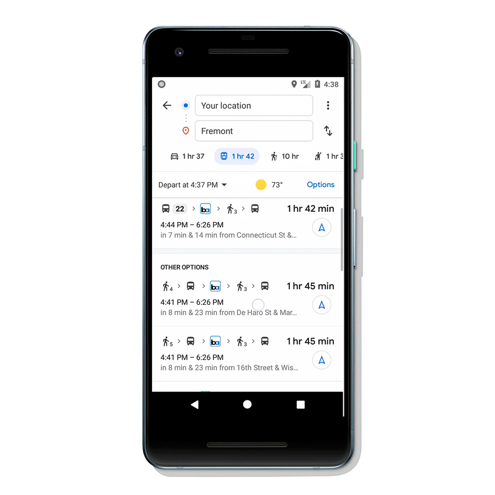
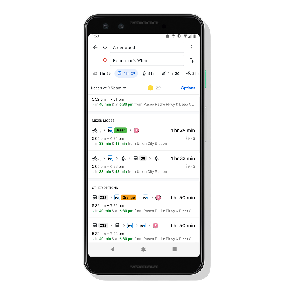
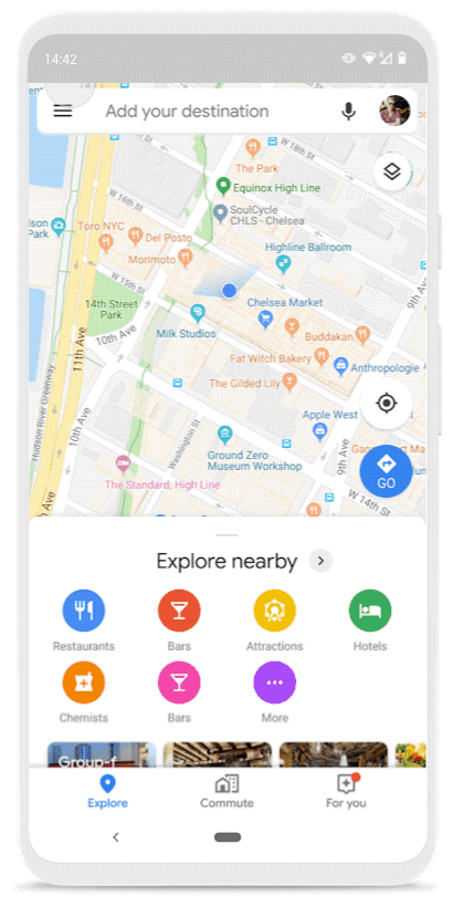
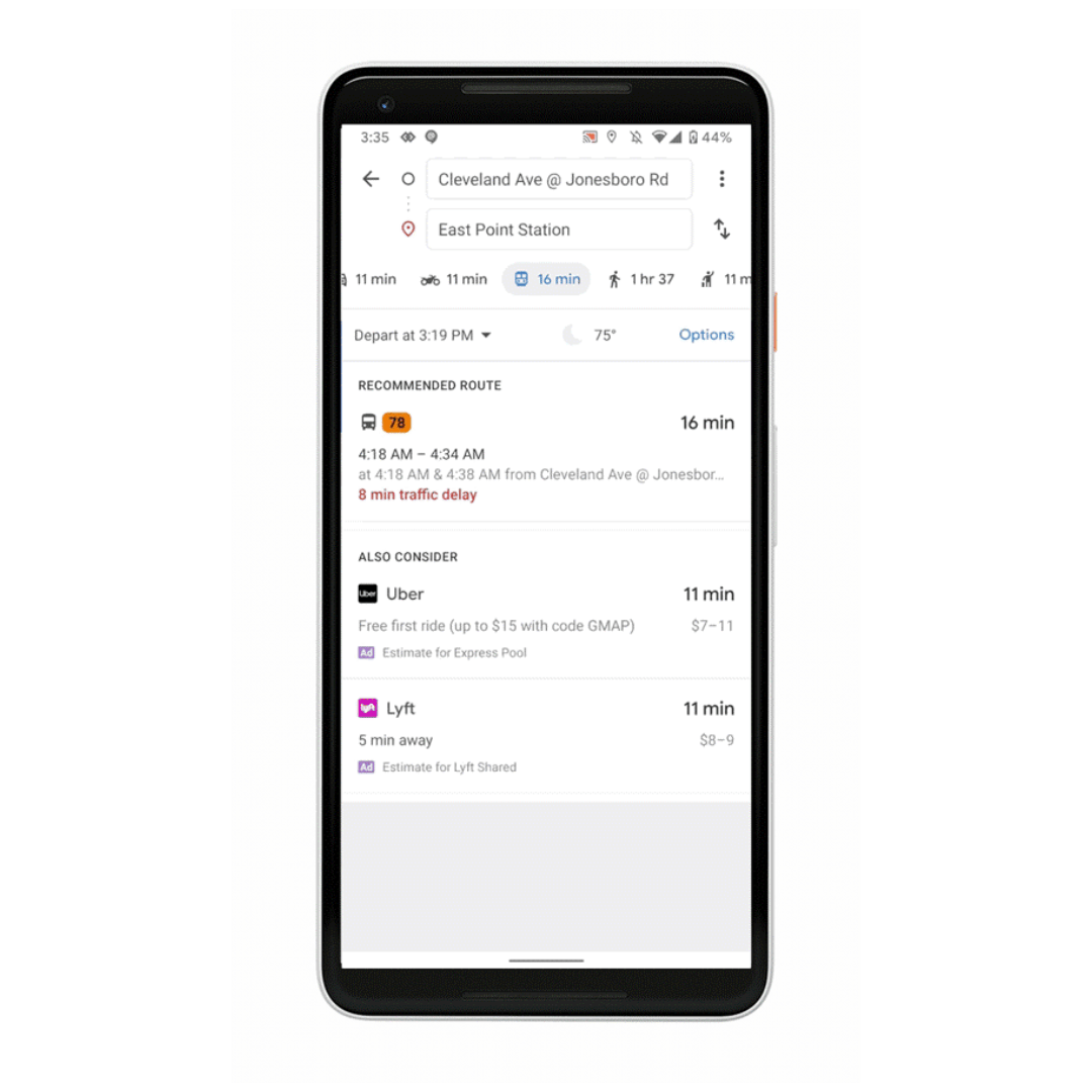
Google Maps has always helped you get from place to place, whether you’re driving, walking, biking or taking public transit. And we know that transit journeys can be complex–often involving multiple modes of transportation to help you get around town. Today, we’re making it easy to pair transit directions with biking and ridesharing options so you can travel that first or last mile with ease.
Say you’re taking the subway home from a friend’s house, but your apartment is a bit too far from the station to get to on foot. Catching a ridesharing vehicle can help you travel that short distance quickly. Or, you’re headed to work at the peak of the busy back-to-school season so you need to ride your bike to the nearest bus stop to make that important 9 a.m. meeting on time.
Here’s how it works:
Enter your destination in the search box, tap on “Directions” and then on the transit tab. From there, you’ll automatically see routes that feature ridesharing and cycling options paired with transit directions. If you’re taking a ridesharing vehicle, you’ll see helpful information about each leg of your trip: how much your ride will cost, how long the wait is, if there’s traffic on your ride, and when your bus or train departs. You can also choose your favorite rideshare provider and other available ride options like pool or economy.
If you’re biking, then you’ll see routes tailored for cyclists along with everything you need to know about the transit portion of your journey. All of this information is automatically factored into your total travel time and ETA so you can know exactly when you’ll get to your destination.
Transit directions paired with biking and ridesharing will start rolling out in the coming weeks on Android and iOS in 30 countries around the globe, with more coming soon.

When I was a kid, my mom would tell me on every birthday she wanted me to have a big goal in life: Travel to as many countries as my years on Earth. And though I'm far from that ambitious target, my mom did instill a major travel bug in me.

Settling in at the Casa Oaxaca hotel.
But no matter where I travel, I struggle with the same issues many people face: pricey phone bills, subpar photos, a language barrier and, well, getting extremely lost.
So when I traveled to Oaxaca, Mexico last month, I sought out ways to combat these typical tourist problems. And thanks to my Pixel 3a, I was able to make real progress for the next time I visit more countries on my bucket list. Here’s how I did it.
Even when I’m traveling, I like to be able to use my phone the same way I would at home. (Meaning, a lot.) For this trip, I decided to set my phone up with Google Fi so I could have unlimited international usage and great coverage. At the end of my trip, my phone bill netted out to be a fraction of my typical charge when I travel internationally.
Thanks to my cheaper data plan, I was also able to navigate with help from Maps. I’d never admit it myself, but some people might say I’m bad at directions. (Okay, a lot of people might say that.) In any case, I really leaned into using Live View in Google Maps, a tool that literally has a big blue arrow staring at me on my screen, pointing me exactly in the direction I should go. Even when in rural areas, outside of cell service, I was grateful to be able to use Google Maps in offline mode—like when I visited the Monte Alban ruins.
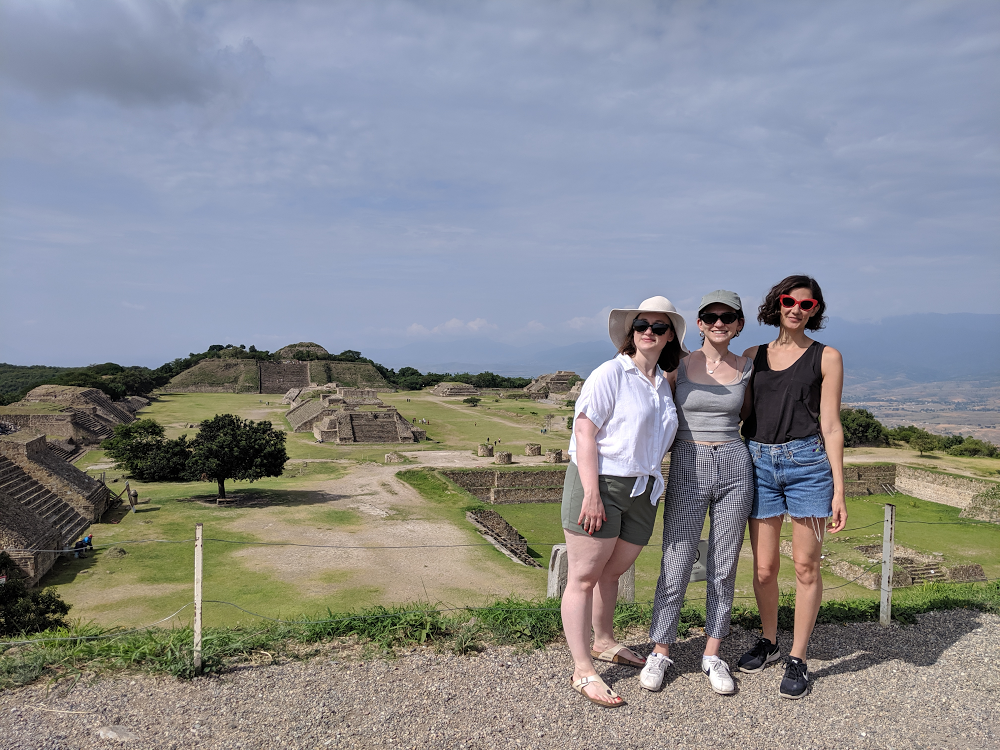
Taking in the beauty of Monte Alban with friends.
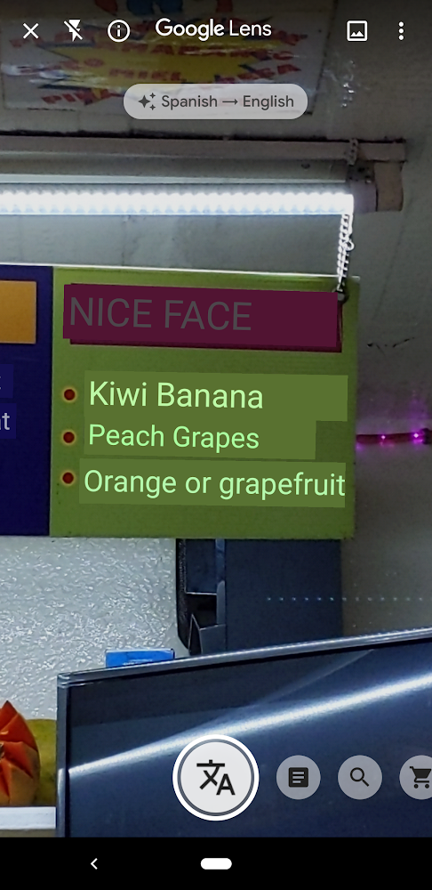
When ordering a juice from a mercado stand, I was able to use Translate in Lens to decipher many of the blends, opting for a juice that promised benefits for my skin.
I’m ashamed to say my Spanish isn’t great, so I put the Pixel 3a to the test. Could it magically help me speak a new language?
Within the camera app, there’s a nifty feature in Google Lens that allows you to hover over text in another language for real-time translations. This came in handy in bustling markets, local restaurants and juice stands that only had menus in Spanish. Even if you don’t have a Pixel phone, you can download the Google Lens app on other Android or iOS devices to try it out yourself.
The Google Assistant also came in handy when I needed language help. It was easy to ask the Assistant questions like, “Hey Google, how do you say ‘where is the bathroom’ in Spanish?” and get help converting costs from pesos to dollars.
In a city as beautiful as Oaxaca, I knew I’d be leaning heavily on the camera quality of the Pixel 3a. I snapped photos throughout a cooking demo making tortillas from scratch, and used features like portrait mode and Night Sight to make the most out of my vacation pics. Here are just a few highlights:
I know, I know, it’s just a phone, but I have to say I feel indebted to my Pixel 3a for showing me such a special time in Oaxaca. I think I’ll take it to my next dream travel destination: Japan.

We’re already a week into August, but there’s still time to book a trip before summer ends--or to get a jump start on holiday travel planning. After you’ve decided where to go for your next trip, these new features can help you get the best price and make travel planning a little simpler.
Book flights with more confidence
When it comes to finding flights, it’s hard to know what the “right” price is--and even harder to know when to book. We already show you whether prices for a flight route are high, low or typical. Starting today you may see the same insights for your exact itinerary. Plus, for some flights we’ll show you how the price has changed over the past few months and notify you when we predict the price may go up soon or won’t get any lower.
On top of this, we’re taking an additional step to give you more confidence when booking a flight. When we predict the price won’t decrease for select itineraries booked between August 13 and September 2, we’ll guarantee the price won’t drop, and we’ll refund you the difference if it does.
We’ll monitor the price for you and if the price drops any time before departure, we’ll send you an email letting you know once your flight takes off--so there’s no work on your end. This feature is available for select itineraries originating in the U.S. with domestic or international destinations.
Get suggestions to continue planning your trip
If you book a flight and receive a confirmation in Gmail, you’ll see your upcoming trip when you go to google.com/travel. Starting this week, we’ll assist you with recommendations for next steps—such as searching for hotels, restaurants and things to do. When you click on your trip, you’ll see your flights have been automatically added to a timeline. If you haven’t received a confirmation in Gmail for some of your trip reservations, you can now easily add them to your timeline.
Find the best neighborhood, and hotel, for you
When you’re booking a hotel, you may need intel on neighborhoods to stay in and what you’ll expect to pay. In the next few weeks, you’ll see helpful information about top neighborhoods, the best time to visit and typical hotel prices at the top of your hotel results on desktop at google.com/travel globally.
Let’s say you’re planning a trip to Paris. Once you’ve searched for hotels for your destination and dates, click on “Where to stay” at the top of your hotel results. For each neighborhood you’ll see a description, the average price and more. You’ll be able to filter your results for hotels in a specific neighborhood.
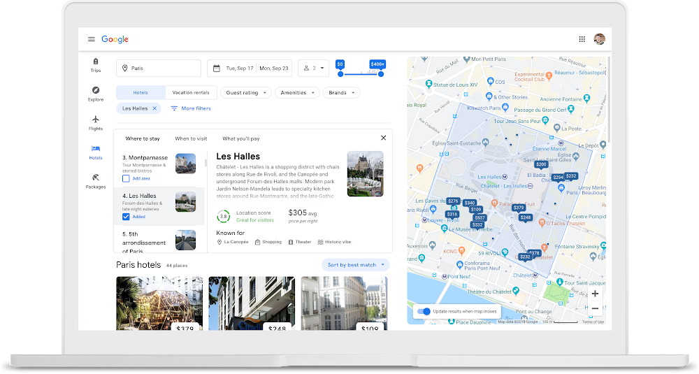
We’ll also help you pick the best place to stay by showing you personalized hotel results including places you’ve searched for or stayed at before, and hotels that are close to points of interest you’ve searched for.
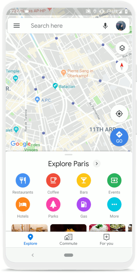
When you’re ready to go on your trip, you can now use Google Maps to access your travel reservations, explore the city you’re visiting or navigate from place to place. Read more about the new features that make Google Maps the perfect travel companion here. Whether you’re looking for the best flight prices and neighborhood for your stay, or you’re on-the-go during your trip, Google can help with your travel needs from start to finish.

Not only does Google Maps help you navigate, explore, and get things done at home, but it’s also a powerful travel companion. After you’ve booked your trip, these new tools will simplify every step of your trip once you’ve touched down–from getting around a new city to reliving every moment once you’re home.
Get organized
Now, you can use Google Maps to see all of your flight and hotel reservations in one place–a lifesaver when you’re checking in at the airport or en route to the next hotel in your destination. Simply tap on the three gray lines at the top left corner of your screen, and then on “Your Places”. Then, hit the “Reservations” tab where you’ll see a list of your upcoming trips. Selecting your trip will instantly pull up your reservations, and you can even access them if you’re offline, so no need to worry if you’re off the grid with no service or traveling internationally without a data plan.
See your flight and hotels reservations right from Google Maps
Get around confidently
There’s nothing like exploring a city on foot–it’s a great way to take in the sights and sounds of a new place. But it can be hard to know exactly which direction to go. With a beta feature called Live View, you can use augmented reality (AR) to better see which way to walk. Arrows and directions are placed in the real world to guide your way. We’ve tested Live View with the Local Guides and Pixel community over the past few months, and are now expanding the beta to Android and iOS devices that support ARCore and ARKit starting this week.
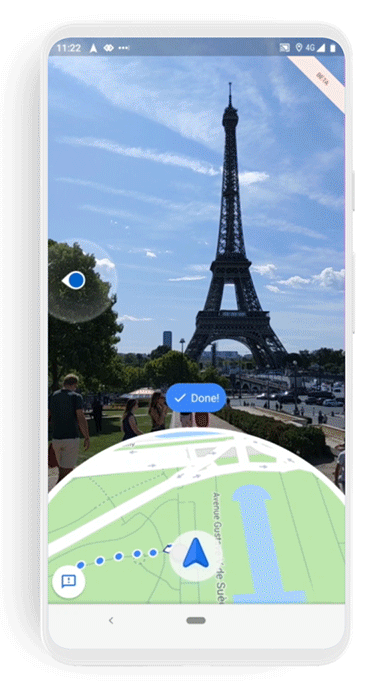
Use Live View to see the way you need to go in a new city
Find amazing local food
Real talk: Food is one of the main highlights of any vacation. With Google Maps, you can quickly find restaurants tailored to your tastes with Your Match, see how long the wait is, and even book a reservation without ever leaving the app (and no, we’re not talking about delicious dinner apps). With the popular dishes feature, you can quickly find out what the must-try items on the menu are.
Find restaurants with Your Match
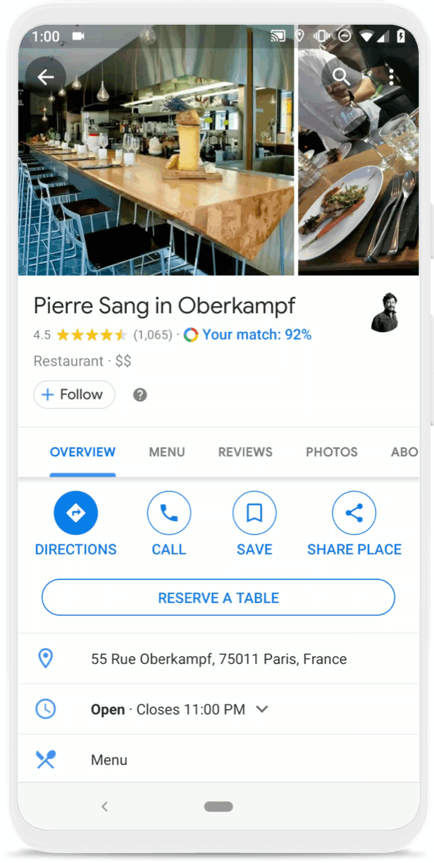
See when a restaurant is most crowded, book a table, and find the most popular dishes
Soak in the memories and share them with friends
The best part about any life-changing trip? Reliving the memories, and sharing them with loved ones. If you’ve chosen to turn your Location History setting on, you can now use the updated version of Timeline to easily remember that amazing hole-in-the-wall restaurant you dined at or the cute vintage shop you popped into. You’ll also be able to see all of the places you went to in a country or a city, and even drill down to the categories of places you visited–including restaurants, shops, attractions, hotels and airports. So the next time someone asks you for trip recommendations, you can easily export the places you loved to a list, make notes about exactly what you liked (like the great picnic spot by the Louvre), and share that list with friends and family.
Use Timeline to remember your trip and share recommendations with friends
You can expect to see flight and hotel reservations, Live View (in countries where Street View is available), and the new Timeline on your phones in the coming weeks. Reservations and Live View are coming to Android and iOS, and the new Timeline is available on Android. To learn more about Google Maps, check out our website.

The world is a beautiful, messy, constantly changing place—roads are added, buildings are built, and new businesses are opened all the time. Our role on the Google Maps team is to accurately model and reflect this ever-evolving world, and we’re often asked how we make a map that does that. The answer is, it takes a number of different steps, and the right mix of people, techniques and technology.
In a series of posts over the coming months, we’ll give you a closer look at how we build our map—diving deep into each of the elements we use to help more than one billion people navigate, explore and get things done. Today, we’ll start with an overview of the basics.
It all starts with imagery
Street View and satellite imagery have long been an important part of how we’re able to identify where places are in the world—it shows us where roadways, buildings, addresses and businesses are located in a region, in addition to other important details—such as the town’s speed limits or business names. In 2007, Street View launched to help people virtually explore the entire world, from the depths of Antarctica to the top of Mount Kilimanjaro. In the 12 years since then, our Street View car and trekker operations have collected more than 170 billion images from 87 countries. Thanks to our newest trekker that is equipped with higher-resolution sensors and increased aperture, we’ve significantly improved the quality of imagery we capture.
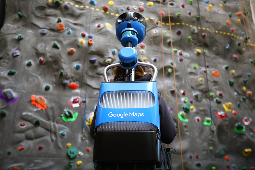
A Street View trekker
Then you add data
Authoritative data brings the map to life. Our data comes from more than 1,000 third-party sources from all over the world. Some, like the United States Geological Survey (USGS) and the National Institute of Statistics and Geography (INEGI) in Mexico, provide information about an entire country. Others are specific to smaller regions, like data from a local municipality, an NGO or a housing developer. Our teams carefully vet every authoritative data source to ensure that we have the most accurate and up-to-date data available. And recently, we introduced a new tool to make it easier for local governments to upload dataabout new roads and addresses in their area, right to Google Maps.
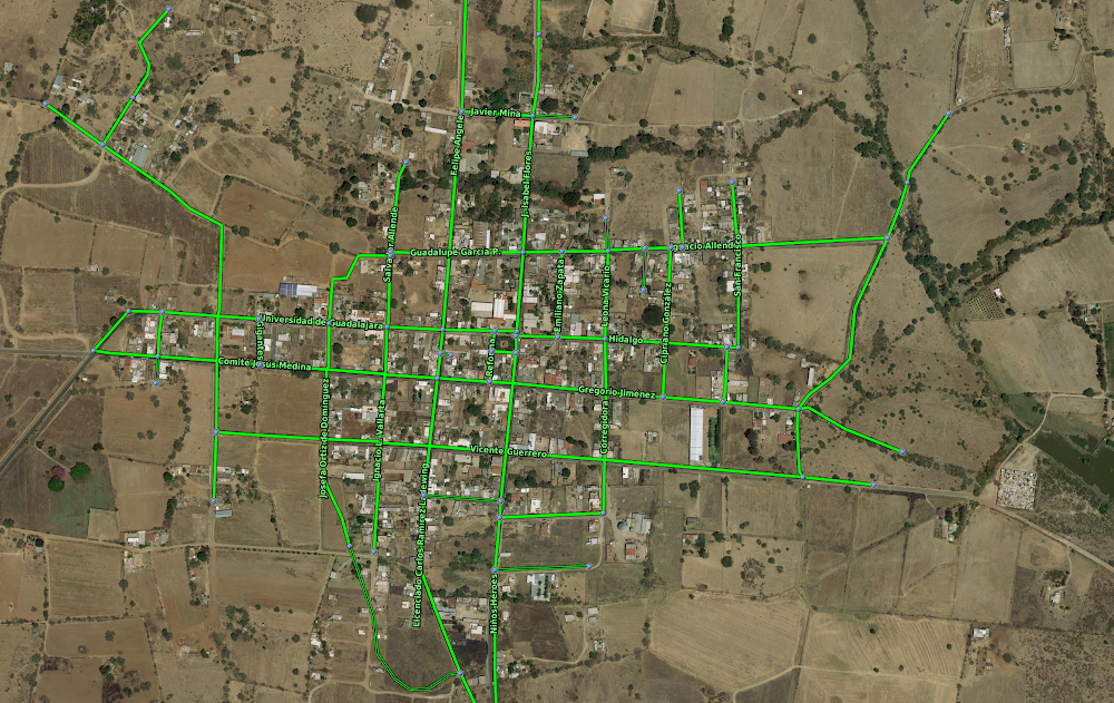
Road outlines from one of our data partners, the National Institute of Statistics and Geography.
A human touch
Data and imagery are key components of mapmaking, but they’re static and can’t always keep up with the pace of how quickly the world changes. This brings us to the third piece: the people that help us tie everything together. We have a data operations team staffed all over the world that plays a role in just about every aspect of mapmaking, from gathering Street View images and vetting authoritative data sources to correcting the map for inaccuracies and training machine learning models (more on that in a second).
We also have our community of Local Guides and Google Maps users, whom we empower to correct the map via the Send Feedback button in Google Maps. Our team reviews the information and publishes it if we have a high degree of confidence that it matches the roads, businesses and addresses in the real world.
Our data operations team at work
Speeding things up with machine learning
Imagery, authoritative data and human input have gotten us to where we are, but we want to make our maps more useful to more people even faster. To increase the speed of our mapping, we turn to machine learning. Machine learning allows our team to automate our mapping processes, while maintaining high levels of accuracy.
Let’s look at how we map building outlines as an example. Previously, an algorithm that tried to guess whether part of an image was a building or not resulted in what we dubbed “fuzzy buildings”—amorphous blobs that didn’t look like real buildings when you draw them on a map. And this was an issue—buildings are more than just buildings—they’re landmarks and a key part of how someone knows where they are when looking at a map. To fix this, we worked with our data operations team to trace common building outlines manually, and then used this information to teach our machine learning algorithms which images correspond with building edges and shapes. This technique proved effective, enabling us to map as many buildings in one year as we mapped in the previous 10.
Fuzzy building outlines on Google Maps.
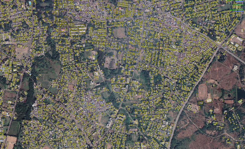
Clear building polygons outlined on the map.
We’re in it for the long haul
Maps are critical to helping communities thrive. They connect people with each other, help grow economies as people discover new businesses and restaurants, and help people get things done. Although we’ve come a long way, with maps in more than 220 countries and territories to date, we know that our work is far from over. Different regions have different needs, and their own mapping challenges. In our next post, we’ll take a closer look at how one component—imagery—helps us overcome these challenges.

Crowdedness predictions come from optional feedback directly from the people who use Google Maps. In fact, you may have received notifications asking about how crowded your subway, train, or bus ride was after navigating in transit mode. To learn more about how crowdedness levels vary around the world, we analyzed aggregated and anonymized reports of crowdedness from Google Maps users from October 2018 to June 2019 during peak commuting hours (6am - 10am), and identified which lines had the highest number of crowdedness reports. Here’s what we found:
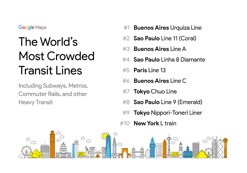
When it comes to the most-crowded transit lines, Buenos Aires and Sao Paulo dominate the rankings–each city has 3 lines in the top 10.
New York’s famed L train–which, until recently, was on the verge of closing for repair– is the only U.S. transit line to make it into the top 10.
Among many U.S. cities, the most-crowded public transit routes are buses. In Los Angeles, for example, bus routes 152, 105, and 704 are among the most-crowded.

On days when everything runs smoothly, taking public transit is one of the best ways to get around town. Not only is it cost-effective and efficient, but it also lets you stay hands free so you can sit back, relax and maybe even read a few chapters of your favorite book. But unexpected delays or overcrowded vehicles can quickly turn your ride from enjoyable to stressful. Starting today, Google Maps is rolling out two new features to help you better plan for your transit ride and stay more comfortable along the way.
When you have an important meeting, a date with a friend, or a doctor’s appointment, often the first thing you’ll do is check the transit schedule to make sure you can make it on time. Unfortunately, transit schedules don’t always reflect real-time traffic conditions that impact your ride, which can cause a lot of unnecessary stress when you end up arriving later than you thought you would.
To solve for this, Google Maps is launching live traffic delays for buses in places where we don’t already have real-time information direct from local transit agencies. You’ll now be able to see if your bus will be late, how long the delay will be, and more accurate travel times based on live traffic conditions along your route. You’ll also see exactly where the delays are on the map so you know what to expect before you even hop on your bus.
Live traffic delays for buses
There’s nothing more uncomfortable than being packed like a can of sardines on a hot, sweaty train. We’re introducing transit crowdedness predictions so you can see how crowded your bus, train or subway is likely to be based on past rides. Now you can make an informed decision about whether or not you want to squeeze on, or wait a few more minutes for a vehicle where you’re more likely to snag a seat.
Crowdedness predictions in transit navigation
You’ll start to see these features roll out on Google Maps in nearly 200 cities around the globe on both Android and iOS today. Interested in learning more about crowdedness trends in your area? Check it out in this post.

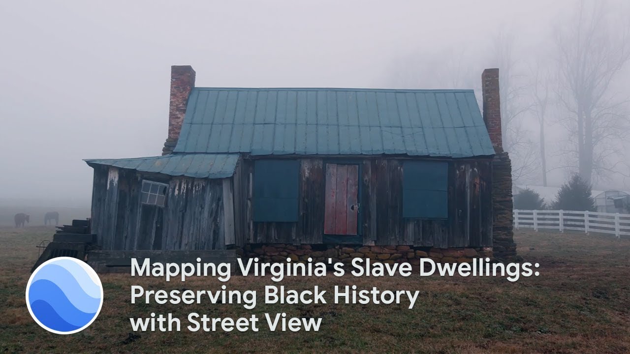
Editor’s note:In honor of Juneteenth, we’re sharing this story about a Google Earth Outreach project that highlights African American history. In today’s post, Justin Reid, Director of African American programs, and Peter Hedlund, Director of Encyclopedia Virginia—both of the state humanities council Virginia Humanities—talk about documenting slave dwellings using Google Street View.
On Virginia’s rural farms, in city townhouses, and beneath grand plantations are spaces where enslaved African-Americans lived from the 1600s until sometimes long after Emancipation. Every day, people pass by these slave dwellings, which are often in disrepair, with no idea who lived there. These dwellings and other African-American historic sites are an important part of Virginia’s history—yet out of the nearly 250,000 cultural and historic resources documented by the state, only one percent are officially identified as reflecting African-American history.
It’s easy to forget about the painful yet important parts of American history when we can’t see them. By immersing ourselves in the places where enslaved communities once lived, we are confronted with a history that cannot be ignored. So to virtually preserve these living spaces and give people access to them, we created custom Street View imagery for tours of a dozen slave dwellings throughout Virginia, which date from the late 1700s to the mid 1800s.
How virtual preservation opens doors to slave dwellings
Several years ago, when Google Street View began to include views of interiors, we saw an opportunity to document slave dwellings for Encyclopedia Virginia, where we collect resources about the state’s history and culture. Most of the former housing sites for enslaved people are on private property, and therefore not open to visitors. Our virtual tours give access to places that people can’t visit in person.The Street View tours also play a role in virtual preservation. Many of the dwellings are in poor condition—even in worse shape than when we started photographing them a few years ago. By creating the virtual tours, we preserve the dwellings for future generations.
For the tours, we consciously chose a range of dwelling types and locations to highlight how ubiquitous slavery was throughout Virginia—from the Eastern Shore to Mecklenburg County. People tend to think that enslaved people only lived on rural plantations. But we have tours of slave dwellings in urban cities like Alexandriaand Richmond, which challenge the stereotypes of how enslaved people lived.
Ensuring enslaved people’s place in history
Justin has a personal connection to the Street View tour of a slave dwelling at Ampthill, a former plantation in Cumberland County. His great-great grandfather, Reverend Jacob Randolph Sr., was born into slavery at Ampthill in 1859. The dwelling in the tour, a brick two-story structure, is beside the main plantation house; the kitchen quarters building, where enslaved people also lived, still stands.The Ampthill slave quarters, where Justin’s great-grandfather may have lived as a child, illustrate the challenges of documenting dwellings. Previous owners of Ampthill thought one of the structures was a post-Civil War weaver’s cottage. When we brought Jobie Hill, a preservation architect and founder of Saving Slave Houses, to Ampthill, she immediately identified the building as a pre-Civil War slave dwelling. So many slave houses are misidentified, which hurts efforts to document them.
We hope that if more people are aware of slave dwellings and view our Street View tours, more sites can be documented and perhaps preserved—and more of us recall the enslaved people who are too often left out of our historical narratives. The people and the places they lived in deserve to be part of the American story.

My father was diagnosed with Type 1 Diabetes as a teenager. He spent most of his life on insulin, until he went into kidney failure when I was four years old. After years on the donor list, a kidney and pancreas became available. He received seven blood transfusions in his 14-hour surgery. But two years later, his body rejected the kidney and he was back to square one. Through the kindness of his brother who was a match, my father received his second kidney transplant, along with several pints of blood. Without blood donors, my father wouldn’t have survived those surgeries and might not be alive today, 20 years later.

Katen and her dad
My father's journey has made me passionate about ensuring that people like him have access to blood when they need it. Although 45 percent of Americans have been personally affected by blood donation, only 3 percent of Americans regularly donate blood.
I’m personally unable to donate blood, but I’ve found another way to give back to the cause: organizing blood drives at Google. Through my work organizing 20 blood drives, I’ve encountered countless others who have personal ties to blood donation, including Googlers like Daniel Otts, who regularly donates blood in memory of his son Ferris who required plasma infusions after being born prematurely. Losing Ferris forever changed Daniel’s outlook on blood donation. “I remember how thankful I was that someone, an anonymous stranger, had given of themselves so unselfishly for the benefit of someone else, quite possibly in a life or death situation,” Daniel told me.
Through these drives, we’ve collected thousands of pints of blood. And through Google’s partnership with the American Red Cross, which uses Google Maps Platform to help people find a blood drive near them, we’ve reached thousands more people across the U.S.
This technology also helped Temie Giwa-Tubosun, a Nigerian native and founder of LifeBank, an app that uses Google Maps Platform to connect blood banks with drivers, hospitals, and patients in need. To date, Temie’s app has drastically cut delivery time of blood from 24 hours to less than 45 minutes and helped save more than 4,000 lives.

Through my own experience, I know how important it is to give blood. And Daniel and Temie are proof of that, too. On World Blood Donor Day, we hope you’ll visit the Red Cross site to find a blood drive near you and plan your donation.